Premium Framed Print > Arts > Artists > O > Abraham Ortelius
Premium Framed Print : Orteliuss map of Europe, 1603


![]()
Framed Photos From Science Photo Library
Orteliuss map of Europe, 1603
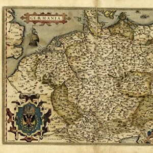
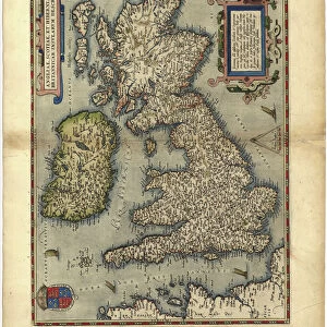
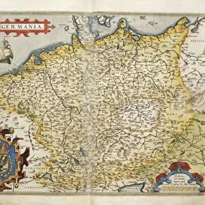
Orteliuss map of Europe. This map of Europe is from the 1603 edition of Theatrum orbis terrarum (Theatre of the World). First published in 1570 by Flemish mapmaker Abraham Ortelius (1527-1598), this collection of 53 maps is considered to be the first true modern atlas. There were two versions of the Europae map: 1570 and 1584. This is the 1603 state of the 1584 version (several states were produced between 1584 and 1609). It includes a compass rose (top right), a scale bar (lower left), and for the title there is a representation of the figure of Europa and the bull (upper left) from Greek mythology, personifying the continent
Science Photo Library features Science and Medical images including photos and illustrations
Media ID 9209757
© MIDDLE TEMPLE LIBRARY/SCIENCE PHOTO LIBRARY
1500s 1584 1600s 16th Century 17th Century Abraham Ortelius Age Of Discovery Baltic Sea Black Sea Bull Cartography Compass Rose Continent Continental Denmark Dutch Europa Flemish France Germany Holland Holy Roman Empire Iceland Ireland Italy Mediterranean Mythological Mythology Netherlands North Africa North Sea Norway Persia Russia Scale Bar Scotland Spain State Sweden Theatre Of The World Theatrum Orbis Terrarum 1603 Austro Hungarian Monarchy Lithuania Low Countries Spanish Empire Tartar
17"x15" (43x38cm) Premium Frame
FSC real wood frame with double mounted 10x8 print. Double mounted with white conservation mountboard. Frame moulding comprises stained composite natural wood veneers (Finger Jointed Pine) 39mm wide by 21mm thick. Archival quality Fujifilm CA photo paper mounted onto 1mm card. Overall outside dimensions are 17x15 inches (431x381mm). Rear features Framing tape to cover staples, 50mm Hanger plate, cork bumpers. Glazed with durable thick 2mm Acrylic to provide a virtually unbreakable glass-like finish. Acrylic Glass is far safer, more flexible and much lighter than typical mineral glass. Moreover, its higher translucency makes it a perfect carrier for photo prints. Acrylic allows a little more light to penetrate the surface than conventional glass and absorbs UV rays so that the image and the picture quality doesn't suffer under direct sunlight even after many years. Easily cleaned with a damp cloth. Please note that, to prevent the paper falling through the mount window and to prevent cropping of the original artwork, the visible print may be slightly smaller to allow the paper to be securely attached to the mount without any white edging showing and to match the aspect ratio of the original artwork.
FSC Real Wood Frame and Double Mounted with White Conservation Mountboard - Professionally Made and Ready to Hang
Estimated Image Size (if not cropped) is 24.4cm x 18.2cm (9.6" x 7.2")
Estimated Product Size is 43.1cm x 38.1cm (17" x 15")
These are individually made so all sizes are approximate
Artwork printed orientated as per the preview above, with landscape (horizontal) orientation to match the source image.
FEATURES IN THESE COLLECTIONS
> Animals
> Insects
> Hemiptera
> Black Scale
> Animals
> Insects
> Hemiptera
> Rose Scale
> Arts
> Artists
> O
> Abraham Ortelius
> Arts
> Artists
> R
> Roman Roman
> Europe
> Denmark
> Related Images
> Maps and Charts
> Abraham Ortelius
EDITORS COMMENTS
This print showcases Orteliuss map of Europe from the 1603 edition of Theatrum orbis terrarum, known as the Theatre of the World. Crafted by Flemish mapmaker Abraham Ortelius in 1570, this collection of 53 maps is hailed as the first true modern atlas. The featured map is a state from the 1584 version, with several states produced between then and 1609. The intricate details on this historical artifact are truly remarkable. In addition to accurately depicting European geography during the 16th century, it includes various elements such as a compass rose at the top right corner and a scale bar at the lower left corner for measurement reference. Notably, its title features an artistic representation of Europa and the bull from Greek mythology—a symbolic personification of our beloved continent. As we delve into this mesmerizing artwork, we can explore countries like Italy, Russia, Ireland, Germany, Sweden, Denmark—each intricately illustrated with their own unique characteristics. From North Africa to Iceland and Norway to Spain—the entire European landscape unfolds before our eyes. This photograph not only captures an important piece of cartography but also offers us a glimpse into history—an era marked by exploration and discovery. It serves as a testament to Ortelius's pioneering work that laid down foundations for future generations' understanding of our ever-evolving world.
MADE IN THE UK
Safe Shipping with 30 Day Money Back Guarantee
FREE PERSONALISATION*
We are proud to offer a range of customisation features including Personalised Captions, Color Filters and Picture Zoom Tools
SECURE PAYMENTS
We happily accept a wide range of payment options so you can pay for the things you need in the way that is most convenient for you
* Options may vary by product and licensing agreement. Zoomed Pictures can be adjusted in the Basket.