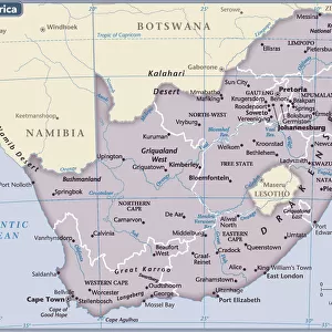
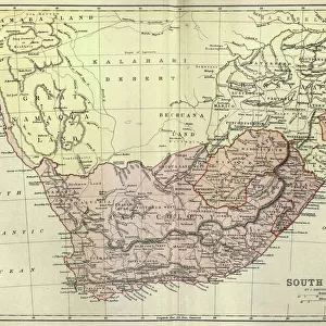
Premium Framed Print : Theatre of war in South Africa - Boer War map


![]()
Framed Photos from Mary Evans Picture Library
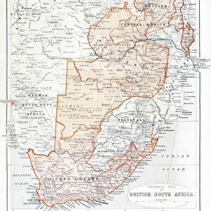
Theatre of war in South Africa - Boer War map
Map of the war in South Africa in 1899. Date: 1899
Mary Evans Picture Library makes available wonderful images created for people to enjoy over the centuries
Media ID 14403293
© Illustrated London News Ltd/Mary Evans
1899 Boer Maps Sep16 Transvaal
17"x15" (43x38cm) Premium Frame
FSC real wood frame with double mounted 10x8 print. Double mounted with white conservation mountboard. Frame moulding comprises stained composite natural wood veneers (Finger Jointed Pine) 39mm wide by 21mm thick. Archival quality Fujifilm CA photo paper mounted onto 1mm card. Overall outside dimensions are 17x15 inches (431x381mm). Rear features Framing tape to cover staples, 50mm Hanger plate, cork bumpers. Glazed with durable thick 2mm Acrylic to provide a virtually unbreakable glass-like finish. Acrylic Glass is far safer, more flexible and much lighter than typical mineral glass. Moreover, its higher translucency makes it a perfect carrier for photo prints. Acrylic allows a little more light to penetrate the surface than conventional glass and absorbs UV rays so that the image and the picture quality doesn't suffer under direct sunlight even after many years. Easily cleaned with a damp cloth. Please note that, to prevent the paper falling through the mount window and to prevent cropping of the original artwork, the visible print may be slightly smaller to allow the paper to be securely attached to the mount without any white edging showing and to match the aspect ratio of the original artwork.
FSC Real Wood Frame and Double Mounted with White Conservation Mountboard - Professionally Made and Ready to Hang
Estimated Image Size (if not cropped) is 21.8cm x 24.4cm (8.6" x 9.6")
Estimated Product Size is 38.1cm x 43.1cm (15" x 17")
These are individually made so all sizes are approximate
Artwork printed orientated as per the preview above, with portrait (vertical) orientation to match the source image.
EDITORS COMMENTS
This map print depicts the Theatre of War in South Africa during the tumultuous year of 1899. As the Boer Wars raged on, the Transvaal and Orange Free State in South Africa became the battleground for British imperial expansion. This intricately detailed map, dated 1899, offers a comprehensive view of the conflict's geographical scope, marking the locations of major battles, British and Boer military camps, and key strategic points. The map's title, "Separate Map of the War in South Africa," underscores the complex political landscape of the region at the time. The Second Boer War, also known as the Anglo-Boer War, pitted the Dutch-speaking Boers against the British Empire, with the former seeking independence and the latter aiming to consolidate its dominion over the Transvaal and Orange Free State. The map's rich cartographic detail provides valuable insights into the military strategies and maneuvers employed by both sides during the conflict. The British forces, led by General Sir Redvers Buller, attempted to encircle the Boer forces through a series of invasions from the east and west. Meanwhile, the Boers, under the command of Paul Kruger and Louis Botha, employed guerrilla warfare tactics, launching surprise attacks on British supply lines and communication networks. This map serves as a poignant reminder of the complex and often brutal history of imperial expansion in Africa. The Boer Wars resulted in significant loss of life and resources for all parties involved, and their legacy continues to shape the political and social landscape of South Africa today.
MADE IN THE UK
Safe Shipping with 30 Day Money Back Guarantee
FREE PERSONALISATION*
We are proud to offer a range of customisation features including Personalised Captions, Color Filters and Picture Zoom Tools
SECURE PAYMENTS
We happily accept a wide range of payment options so you can pay for the things you need in the way that is most convenient for you
* Options may vary by product and licensing agreement. Zoomed Pictures can be adjusted in the Basket.