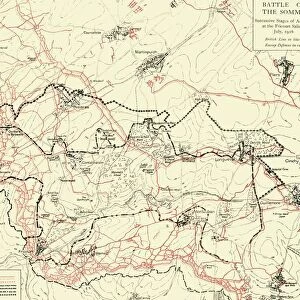
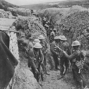
Premium Framed Print > Historic > Battles > Battle of the Somme > Trench warfare
Premium Framed Print : WW1 - Trench map from a soldiers war diary showing the Somme Battlefield with


![]()
Framed Photos from Mary Evans Picture Library
WW1 - Trench map from a soldiers war diary showing the Somme Battlefield with
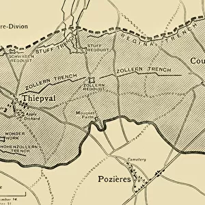
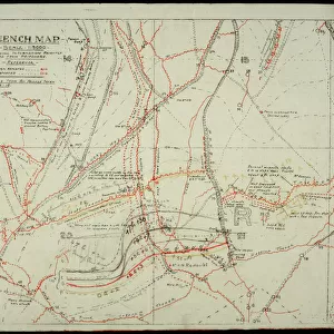
WW1 - Trench map from a soldiers war diary showing the Somme Battlefield with information gleaned from captured German Prisoners. The Regina Trench (Staufen Riegel), Stuff Redoubt (Staufenfeste) and Lucky Way are both shown. Date: circa 1916
Mary Evans Picture Library makes available wonderful images created for people to enjoy over the centuries
Media ID 23394862
© Mary Evans / The National Archives, London. England
Battlefield Chart Diary Fortifications Fronts Geography Information Layout Lines Lucky Marked Markings Plan Redoubt Regina Somme Stuff Thiepval Trench Trenches Riegel Sars
17"x15" (43x38cm) Premium Frame
FSC real wood frame with double mounted 10x8 print. Double mounted with white conservation mountboard. Frame moulding comprises stained composite natural wood veneers (Finger Jointed Pine) 39mm wide by 21mm thick. Archival quality Fujifilm CA photo paper mounted onto 1mm card. Overall outside dimensions are 17x15 inches (431x381mm). Rear features Framing tape to cover staples, 50mm Hanger plate, cork bumpers. Glazed with durable thick 2mm Acrylic to provide a virtually unbreakable glass-like finish. Acrylic Glass is far safer, more flexible and much lighter than typical mineral glass. Moreover, its higher translucency makes it a perfect carrier for photo prints. Acrylic allows a little more light to penetrate the surface than conventional glass and absorbs UV rays so that the image and the picture quality doesn't suffer under direct sunlight even after many years. Easily cleaned with a damp cloth. Please note that, to prevent the paper falling through the mount window and to prevent cropping of the original artwork, the visible print may be slightly smaller to allow the paper to be securely attached to the mount without any white edging showing and to match the aspect ratio of the original artwork.
FSC Real Wood Frame and Double Mounted with White Conservation Mountboard - Professionally Made and Ready to Hang
Estimated Image Size (if not cropped) is 24.4cm x 19.6cm (9.6" x 7.7")
Estimated Product Size is 43.1cm x 38.1cm (17" x 15")
These are individually made so all sizes are approximate
Artwork printed orientated as per the preview above, with landscape (horizontal) orientation to match the source image.
FEATURES IN THESE COLLECTIONS
> Mary Evans Prints Online
> New Images August 2021
> Animals
> Mammals
> Muridae
> Western Mouse
> Europe
> United Kingdom
> England
> Maps
> Europe
> United Kingdom
> England
> Posters
> Europe
> United Kingdom
> England
> Related Images
> Historic
> Battles
> Battle of the Somme
> Battlefields of World War I
> Historic
> Battles
> Battle of the Somme
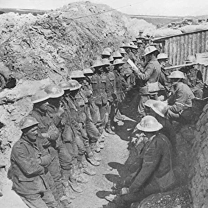
> Soldiers in battle
> Historic
> Battles
> Battle of the Somme
> Trench warfare
> Historic
> Battles
> Battle of the Somme
> Western Front battles
> Historic
> Battles
> Battle of the Somme
> Historic
> Battles
> Related Images
EDITORS COMMENTS
This evocative WWI trench map, extracted from a soldier's war diary, offers a fascinating glimpse into the complex geography of the Somme Battlefield during the Great War. Dated circa 1916, the map meticulously charts the intricate layout of the opposing lines and fortifications along the Western Front. The map's focus is on the area around the Regina Trench (Staufen Riegel) and the Stuff Redoubt (Staufenfeste), both prominent features of the German defenses. The Regina Trench, marked with a thick red line, snakes its way across the landscape, while the Stuff Redoubt, denoted by a solid red star, looms ominously in the upper right corner. Of particular interest are the markings and annotations scribbled on the map, likely gleaned from captured German prisoners or intelligence reports. These insights provide valuable context to the map, revealing the strategic importance of specific locations and the ever-shifting nature of the battlefield. The map also includes other notable landmarks, such as the village of Le Sars and the formidable Thiepval Wood, which played significant roles in the fierce fighting that took place in this sector of the Western Front. The Lucky Way, a narrow path leading to the British lines, is also marked, underscoring the importance of even the smallest of tactical advantages in the brutal and unforgiving landscape of the Somme Battlefield. This intricately detailed trench map serves as a poignant reminder of the complex and often deadly dance of war, as soldiers on both sides navigated the labyrinthine trenches and fortifications that defined the Western Front during World War I.
MADE IN THE UK
Safe Shipping with 30 Day Money Back Guarantee
FREE PERSONALISATION*
We are proud to offer a range of customisation features including Personalised Captions, Color Filters and Picture Zoom Tools
SECURE PAYMENTS
We happily accept a wide range of payment options so you can pay for the things you need in the way that is most convenient for you
* Options may vary by product and licensing agreement. Zoomed Pictures can be adjusted in the Basket.