Premium Framed Print > Arts > Artists > R > Roman Roman
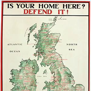
Premium Framed Print : Map of Pre-Roman Brits


![]()
Framed Photos from Mary Evans Picture Library
Map of Pre-Roman Brits
A map showing the distribution of tribes in pre- Roman Britain
Mary Evans Picture Library makes available wonderful images created for people to enjoy over the centuries
Media ID 4362729
© Mary Evans Picture Library 2015 - https://copyrighthub.org/s0/hub1/creation/maryevans/MaryEvansPictureID/10117076
Brits Distribution Maps Tribes
17"x15" (43x38cm) Premium Frame
FSC real wood frame with double mounted 10x8 print. Double mounted with white conservation mountboard. Frame moulding comprises stained composite natural wood veneers (Finger Jointed Pine) 39mm wide by 21mm thick. Archival quality Fujifilm CA photo paper mounted onto 1mm card. Overall outside dimensions are 17x15 inches (431x381mm). Rear features Framing tape to cover staples, 50mm Hanger plate, cork bumpers. Glazed with durable thick 2mm Acrylic to provide a virtually unbreakable glass-like finish. Acrylic Glass is far safer, more flexible and much lighter than typical mineral glass. Moreover, its higher translucency makes it a perfect carrier for photo prints. Acrylic allows a little more light to penetrate the surface than conventional glass and absorbs UV rays so that the image and the picture quality doesn't suffer under direct sunlight even after many years. Easily cleaned with a damp cloth. Please note that, to prevent the paper falling through the mount window and to prevent cropping of the original artwork, the visible print may be slightly smaller to allow the paper to be securely attached to the mount without any white edging showing and to match the aspect ratio of the original artwork.
FSC Real Wood Frame and Double Mounted with White Conservation Mountboard - Professionally Made and Ready to Hang
Estimated Image Size (if not cropped) is 19.7cm x 24.4cm (7.8" x 9.6")
Estimated Product Size is 38.1cm x 43.1cm (15" x 17")
These are individually made so all sizes are approximate
Artwork printed orientated as per the preview above, with portrait (vertical) orientation to match the source image.
FEATURES IN THESE COLLECTIONS
> Arts
> Artists
> R
> Roman Roman
> Maps and Charts
> Early Maps
> Maps and Charts
> Related Images
EDITORS COMMENTS
This fascinating historical map, "Map of Pre-Roman Brits," offers a glimpse into the distribution of tribes in pre-Roman Britain during the 1st century BC. The intricate details and markings on the map provide valuable insights into the rich history and culture of ancient Britain before it was conquered by the Roman Empire.
As we study this map, we can see how different tribes were spread out across the land, each with its own unique territory and customs. From the powerful Brigantes in northern England to the fierce Iceni in East Anglia, each tribe played a significant role in shaping the landscape of pre-Roman Britain.
The careful craftsmanship and attention to detail on this print allow us to visualize what life might have been like for these ancient Britons as they navigated their way through tribal territories and interacted with neighboring groups. It serves as a reminder of our shared heritage and connection to those who came before us.
Whether you are a history buff or simply curious about ancient civilizations, this "Map of Pre-Roman Brits" is sure to spark your imagination and transport you back in time to an era filled with intrigue, conflict, and cultural exchange. Explore this piece of history today through Rights Managed's collection at Mary Evans Prints Online.
MADE IN THE UK
Safe Shipping with 30 Day Money Back Guarantee
FREE PERSONALISATION*
We are proud to offer a range of customisation features including Personalised Captions, Color Filters and Picture Zoom Tools
SECURE PAYMENTS
We happily accept a wide range of payment options so you can pay for the things you need in the way that is most convenient for you
* Options may vary by product and licensing agreement. Zoomed Pictures can be adjusted in the Basket.