Home > Europe > United Kingdom > England > Maps
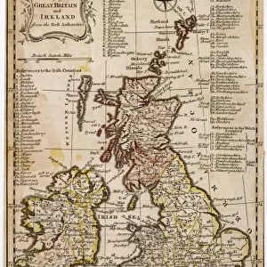
Map of Ireland in the sixth century, from the book The Church of England: A

![]()
Wall Art and Photo Gifts from Fine Art Finder
Map of Ireland in the sixth century, from the book The Church of England: A
KW293340 Map of Ireland in the sixth century, from the book The Church of England: A History for the People, published c.1910 (litho) by English School, (20th century); Private Collection; Ken Welsh; English, out of copyright
Media ID 12815999
© www.bridgemanimages.com
C06th Cartography Connaught Eire Geographical Leinster Mapping Munster Ulster
FEATURES IN THESE COLLECTIONS
> Europe
> Republic of Ireland
> Maps
> Europe
> United Kingdom
> England
> Maps
> Fine Art Finder
> Maps (celestial & Terrestrial)
> Fine Art Finder
> Schools
> English School
> Maps and Charts
> Early Maps
EDITORS COMMENTS
This black and white lithograph takes us back in time to the sixth century, offering a glimpse into the historical geography of Ireland. The intricate details of this map, sourced from the book "The Church of England: A History for the People" published around 1910, provide an intriguing insight into the island's past. Stretching across the print is a meticulously drawn outline of Ireland, showcasing its four ancient provinces: Ulster, Leinster, Munster, and Connaught. Each region is clearly delineated with delicate lines that highlight their individual boundaries. This map serves as a testament to the rich cartographic tradition that has shaped our understanding of geographical landscapes throughout history. As we study this image further, it becomes apparent that it offers more than just geographical information. It also provides valuable insights into Ireland's religious history during this period. The title suggests that it was originally intended as an educational tool for readers interested in learning about the Church of England. Preserved within a private collection today and made available through Bridgeman Images' Fine Art Finder platform, this print invites us to explore Ireland's past through its carefully crafted representation. Whether you are captivated by historical mapping or fascinated by Irish heritage and culture, this lithograph offers a unique window into both realms - allowing us to appreciate how art can intertwine with knowledge and transport us across centuries.
MADE IN THE UK
Safe Shipping with 30 Day Money Back Guarantee
FREE PERSONALISATION*
We are proud to offer a range of customisation features including Personalised Captions, Color Filters and Picture Zoom Tools
SECURE PAYMENTS
We happily accept a wide range of payment options so you can pay for the things you need in the way that is most convenient for you
* Options may vary by product and licensing agreement. Zoomed Pictures can be adjusted in the Basket.