Premium Framed Print > Europe > United Kingdom > Wales > Monmouthshire > Monmouth
Premium Framed Print : Pictorial History Map of Wales and Monmouth 1966


![]()
Framed Photos from MapSeeker
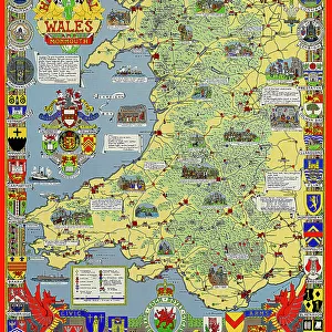
Pictorial History Map of Wales and Monmouth 1966
This is a wonderful pictorial map illustrating the history of Wales drawn by Leslie Bullock and published in c1966 by Collins Bartholomew as a fold up map. Now re-digitized and re-published by Mapseeker in association with the Collins Bartholomew Archive, the map covers all of Wales and Monmouth with historical locations and events illustrated pictorially in the form of charming cartoon vignettes. The map is surrounded by the armorial crests of Wales
Welcome to the Mapseeker Image library and enter an historic gateway to one of the largest on-line collections of Historic Maps, Nostalgic Views, Vista's and Panorama's from a World gone by.
Media ID 20347935
23"x19" (58x48cm) Premium Frame
FSC real wood frame with double mounted 16x12 print. Double mounted with white conservation mountboard. Frame moulding comprises stained composite natural wood veneers (Finger Jointed Pine) 39mm wide by 21mm thick. Archival quality Fujifilm CA photo paper mounted onto 1mm card. Overall outside dimensions are 23x19 inches (584x482mm). Rear features Framing tape to cover staples, 50mm Hanger plate, cork bumpers. Glazed with durable thick 2mm Acrylic to provide a virtually unbreakable glass-like finish. Acrylic Glass is far safer, more flexible and much lighter than typical mineral glass. Moreover, its higher translucency makes it a perfect carrier for photo prints. Acrylic allows a little more light to penetrate the surface than conventional glass and absorbs UV rays so that the image and the picture quality doesn't suffer under direct sunlight even after many years. Easily cleaned with a damp cloth. Please note that, to prevent the paper falling through the mount window and to prevent cropping of the original artwork, the visible print may be slightly smaller to allow the paper to be securely attached to the mount without any white edging showing and to match the aspect ratio of the original artwork.
FSC Real Wood Frame and Double Mounted with White Conservation Mountboard - Professionally Made and Ready to Hang
Estimated Image Size (if not cropped) is 26.4cm x 39.6cm (10.4" x 15.6")
Estimated Product Size is 48.2cm x 58.4cm (19" x 23")
These are individually made so all sizes are approximate
Artwork printed orientated as per the preview above, with portrait (vertical) orientation to match the source image.
FEATURES IN THESE COLLECTIONS
> MapSeeker
> Maps from the British Isles
> Wales and Counties PORTFOLIO
> MapSeeker
> Pictorial Maps and Pictorial History
> Pictorial History Maps PORTFOLIO
> Europe
> United Kingdom
> Wales
> Maps
> Europe
> United Kingdom
> Wales
> Monmouthshire
> Monmouth
> Europe
> United Kingdom
> Wales
> Posters
> Europe
> United Kingdom
> Wales
> Related Images
> Maps and Charts
> Early Maps
> Maps and Charts
> Related Images
> Maps and Charts
> Wales
EDITORS COMMENTS
This print showcases the "Pictorial History Map of Wales and Monmouth 1966" a remarkable piece of artistry by Leslie Bullock. Originally published as a fold-up map in collaboration with Collins Bartholomew, this historical gem has now been re-digitized and re-published by Mapseeker, in association with the esteemed Collins Bartholomew Archive. The map itself spans across the entirety of Wales and Monmouth, offering an enchanting visual narrative of their rich history. Through delightful cartoon vignettes, Bullock skillfully depicts various significant locations and events that have shaped these lands over time. Each pictorial illustration serves as a window into the past, transporting viewers to key moments in Welsh history. Surrounding the map are the armorial crests of Wales, adding an air of regality to this already impressive artwork. These heraldic symbols pay homage to Wales' proud heritage and noble lineage. While it is important to note that this print is not intended for commercial use, its true value lies in its ability to educate and inspire. Whether you are a history enthusiast or simply appreciate fine craftsmanship, this Pictorial History Map offers a unique perspective on Wales' fascinating past. With every glance at its intricate details, one can't help but be captivated by the beauty and charm encapsulated within this extraordinary piece of cartographic art.
MADE IN THE UK
Safe Shipping with 30 Day Money Back Guarantee
FREE PERSONALISATION*
We are proud to offer a range of customisation features including Personalised Captions, Color Filters and Picture Zoom Tools
SECURE PAYMENTS
We happily accept a wide range of payment options so you can pay for the things you need in the way that is most convenient for you
* Options may vary by product and licensing agreement. Zoomed Pictures can be adjusted in the Basket.