Premium Framed Print > Europe > United Kingdom > Scotland > Strathclyde > Glasgow
Premium Framed Print : Old Map of Glasgow Scotland 1851 by John Tallis


![]()
Framed Photos from MapSeeker
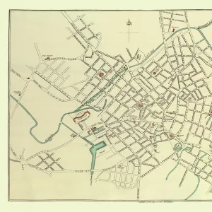
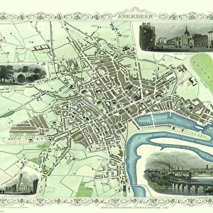
Old Map of Glasgow Scotland 1851 by John Tallis
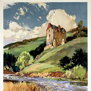
The River Clyde skirts its way through the heart of this famous Scottish City in this wonderful plan by Tallis originally published in 1851. There are six illustrations on the plan. These illustrations are a set of picturesque views, The Exchange, the Cathedral, Royal Bank of Scotland, The University, the New Bridge over the Clyde and a lovely view of Glasgow from The Green
Welcome to the Mapseeker Image library and enter an historic gateway to one of the largest on-line collections of Historic Maps, Nostalgic Views, Vista's and Panorama's from a World gone by.
Media ID 20347884
Historic Map John Tallis John Tallis Map Old Town Plan Tallis Map
23"x19" (58x48cm) Premium Frame
FSC real wood frame with double mounted 16x12 print. Double mounted with white conservation mountboard. Frame moulding comprises stained composite natural wood veneers (Finger Jointed Pine) 39mm wide by 21mm thick. Archival quality Fujifilm CA photo paper mounted onto 1mm card. Overall outside dimensions are 23x19 inches (584x482mm). Rear features Framing tape to cover staples, 50mm Hanger plate, cork bumpers. Glazed with durable thick 2mm Acrylic to provide a virtually unbreakable glass-like finish. Acrylic Glass is far safer, more flexible and much lighter than typical mineral glass. Moreover, its higher translucency makes it a perfect carrier for photo prints. Acrylic allows a little more light to penetrate the surface than conventional glass and absorbs UV rays so that the image and the picture quality doesn't suffer under direct sunlight even after many years. Easily cleaned with a damp cloth. Please note that, to prevent the paper falling through the mount window and to prevent cropping of the original artwork, the visible print may be slightly smaller to allow the paper to be securely attached to the mount without any white edging showing and to match the aspect ratio of the original artwork.
FSC Real Wood Frame and Double Mounted with White Conservation Mountboard - Professionally Made and Ready to Hang
Estimated Image Size (if not cropped) is 39.6cm x 26.4cm (15.6" x 10.4")
Estimated Product Size is 58.4cm x 48.2cm (23" x 19")
These are individually made so all sizes are approximate
Artwork printed orientated as per the preview above, with landscape (horizontal) orientation to match the source image.
FEATURES IN THESE COLLECTIONS
> MapSeeker
> British Town And City Plans
> Scottish PORTFOLIO
> Arts
> Artists
> T
> John Tallis
> Europe
> United Kingdom
> Scotland
> Glasgow
> Europe
> United Kingdom
> Scotland
> Maps
> Europe
> United Kingdom
> Scotland
> Rivers
> Europe
> United Kingdom
> Scotland
> Strathclyde
> Glasgow
> Maps and Charts
> Related Images
EDITORS COMMENTS
This print showcases an exquisite piece of history - the "Old Map of Glasgow Scotland 1851" by John Tallis. Stepping back in time, we are transported to the heart of this renowned Scottish city, where the majestic River Clyde gracefully winds its way through its bustling streets. Originally published in 1851, this remarkable plan by Tallis offers a glimpse into Glasgow's past. The map is adorned with six enchanting illustrations that add a touch of charm to the overall composition. These picturesque views include notable landmarks such as The Exchange, the Cathedral, Royal Bank of Scotland, The University, and even a delightful perspective of Glasgow from The Green. As we explore this historic map further, it becomes evident that every detail has been meticulously crafted. From street names to intricate architectural features, each element invites us to immerse ourselves in the rich tapestry of Glasgow's heritage. Whether you are an avid collector or simply intrigued by historical cartography, this old town plan holds immense value for anyone seeking a deeper understanding and appreciation for Glasgow's evolution over time. It serves as a testament to John Tallis' artistry and his dedication to preserving moments frozen within maps
MADE IN THE UK
Safe Shipping with 30 Day Money Back Guarantee
FREE PERSONALISATION*
We are proud to offer a range of customisation features including Personalised Captions, Color Filters and Picture Zoom Tools
SECURE PAYMENTS
We happily accept a wide range of payment options so you can pay for the things you need in the way that is most convenient for you
* Options may vary by product and licensing agreement. Zoomed Pictures can be adjusted in the Basket.