Premium Framed Print > Arts > Artists > G > Charles Green
Premium Framed Print : Old Map of Liverpool 1785 by Surveyed by Charles Eyes


![]()
Framed Photos from MapSeeker
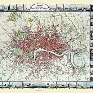
Old Map of Liverpool 1785 by Surveyed by Charles Eyes
This most impressive reproduction map has been completely art worked in full colour from the very rare antique original, large, black and white, detailed plan of Liverpool published by Charles Eyes. The map is a truly local publication as it was also engraved in Liverpool - by Thomas Condor. It has been painstakingly reproduced and shows the green hedgerows of lands not yet built upon, and for each shows the names of the respective landowners, which makes this work a treasure trove to those researching family history, genealogists and those keen on the history of Liverpool. All docks are named, roads and streets, important buildings as well as the occasional windmill. Some of these landownerAEs names were given to some of the streets that rapidly spread out into the rural aspects of the time, for example Bold Street has recently been cut, yet the plan still shows the adjacent land owned by oMr Boldo
Welcome to the Mapseeker Image library and enter an historic gateway to one of the largest on-line collections of Historic Maps, Nostalgic Views, Vista's and Panorama's from a World gone by.
Media ID 20348247
City Of Liverpool Map Historic Liverpool Map Historic Map Liverpool Liverpool City Liverpool City Map Liverpool Map Liverpool Town Plan Map Of Liverpool Old Map Of Liverpool Old Town Plan Town Plan Of Liverpool
17"x15" (43x38cm) Premium Frame
FSC real wood frame with double mounted 10x8 print. Double mounted with white conservation mountboard. Frame moulding comprises stained composite natural wood veneers (Finger Jointed Pine) 39mm wide by 21mm thick. Archival quality Fujifilm CA photo paper mounted onto 1mm card. Overall outside dimensions are 17x15 inches (431x381mm). Rear features Framing tape to cover staples, 50mm Hanger plate, cork bumpers. Glazed with durable thick 2mm Acrylic to provide a virtually unbreakable glass-like finish. Acrylic Glass is far safer, more flexible and much lighter than typical mineral glass. Moreover, its higher translucency makes it a perfect carrier for photo prints. Acrylic allows a little more light to penetrate the surface than conventional glass and absorbs UV rays so that the image and the picture quality doesn't suffer under direct sunlight even after many years. Easily cleaned with a damp cloth. Please note that, to prevent the paper falling through the mount window and to prevent cropping of the original artwork, the visible print may be slightly smaller to allow the paper to be securely attached to the mount without any white edging showing and to match the aspect ratio of the original artwork.
FSC Real Wood Frame and Double Mounted with White Conservation Mountboard - Professionally Made and Ready to Hang
Estimated Image Size (if not cropped) is 24.4cm x 18.3cm (9.6" x 7.2")
Estimated Product Size is 43.1cm x 38.1cm (17" x 15")
These are individually made so all sizes are approximate
Artwork printed orientated as per the preview above, with landscape (horizontal) orientation to match the source image.
FEATURES IN THESE COLLECTIONS
> MapSeeker
> British Town And City Plans
> English & Welsh PORTFOLIO
> Arts
> Artists
> G
> Charles Green
> Arts
> Artists
> W
> Charles White
> Arts
> Photorealistic artworks
> Detailed art pieces
> Masterful detailing in art
> Europe
> France
> Canton
> Landes
> Maps and Charts
> Related Images
EDITORS COMMENTS
This stunning reproduction of the "Old Map of Liverpool 1785" by Charles Eyes is a true gem for history enthusiasts and genealogists alike. The map, originally published in large black and white format, has been meticulously art worked in full color to bring out its intricate details. Surveyed and engraved right here in Liverpool by Charles Eyes and Thomas Condor respectively, this local publication provides an authentic glimpse into the city's past. It showcases the green hedgerows that once covered lands yet to be developed, with each plot labeled with the names of its respective landowners. This feature makes it an invaluable resource for those researching family history or delving into genealogy. The map not only highlights all docks but also identifies roads, streets, important buildings, and even windmills scattered across Liverpool at that time. Interestingly enough, some of these landowners' names were later given to streets that rapidly expanded into what we now know as Bold Street - adjacent to Mr. Boldo's owned land. For anyone curious about Liverpool's rich history or seeking a connection to their ancestors who once called this city home, this historic map is a treasure trove worth exploring. Immerse yourself in the past as you trace the footsteps of those who walked these streets centuries ago through this piece of cartographic artistry.
MADE IN THE UK
Safe Shipping with 30 Day Money Back Guarantee
FREE PERSONALISATION*
We are proud to offer a range of customisation features including Personalised Captions, Color Filters and Picture Zoom Tools
SECURE PAYMENTS
We happily accept a wide range of payment options so you can pay for the things you need in the way that is most convenient for you
* Options may vary by product and licensing agreement. Zoomed Pictures can be adjusted in the Basket.