Premium Framed Print > Asia > Saudi Arabia > Maps
Premium Framed Print : Africa Political Map


![]()
Framed Photos from Map Marketing
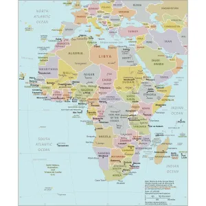
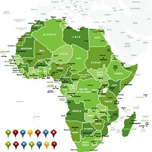
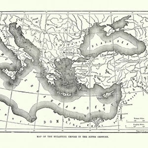
Africa Political Map
The Map Marketing Africa Political Map is an exceptionally clear map of the whole of Africa Including the Saudi Arabian Peninsula, Turkey, Iran and the southern Mediterranean countries. Countries are colour coded with a comprehensive coverage of towns and cities. Also shown are roads, major international airports (with ATA codes), international boundaries, rivers, lakes, deserts and swamps. In addition, the flags of all the African countries are included in an inset box
Media ID 19949233
© Map Marketing Ltd
23"x19" (58x48cm) Premium Frame
FSC real wood frame with double mounted 16x12 print. Double mounted with white conservation mountboard. Frame moulding comprises stained composite natural wood veneers (Finger Jointed Pine) 39mm wide by 21mm thick. Archival quality Fujifilm CA photo paper mounted onto 1mm card. Overall outside dimensions are 23x19 inches (584x482mm). Rear features Framing tape to cover staples, 50mm Hanger plate, cork bumpers. Glazed with durable thick 2mm Acrylic to provide a virtually unbreakable glass-like finish. Acrylic Glass is far safer, more flexible and much lighter than typical mineral glass. Moreover, its higher translucency makes it a perfect carrier for photo prints. Acrylic allows a little more light to penetrate the surface than conventional glass and absorbs UV rays so that the image and the picture quality doesn't suffer under direct sunlight even after many years. Easily cleaned with a damp cloth. Please note that, to prevent the paper falling through the mount window and to prevent cropping of the original artwork, the visible print may be slightly smaller to allow the paper to be securely attached to the mount without any white edging showing and to match the aspect ratio of the original artwork.
FSC Real Wood Frame and Double Mounted with White Conservation Mountboard - Professionally Made and Ready to Hang
Estimated Image Size (if not cropped) is 26.4cm x 39.6cm (10.4" x 15.6")
Estimated Product Size is 48.2cm x 58.4cm (19" x 23")
These are individually made so all sizes are approximate
Artwork printed orientated as per the preview above, with portrait (vertical) orientation to match the source image.
FEATURES IN THESE COLLECTIONS
> Asia
> Iran
> Lakes
> Related Images
> Asia
> Iran
> Related Images
> Asia
> Saudi Arabia
> Maps
> Asia
> Saudi Arabia
> Related Images
> Asia
> Turkey
> Lakes
> Related Images
> Asia
> Turkey
> Related Images
> Maps and Charts
> Popular Maps
> Maps and Charts
> Related Images
MADE IN THE UK
Safe Shipping with 30 Day Money Back Guarantee
FREE PERSONALISATION*
We are proud to offer a range of customisation features including Personalised Captions, Color Filters and Picture Zoom Tools
SECURE PAYMENTS
We happily accept a wide range of payment options so you can pay for the things you need in the way that is most convenient for you
* Options may vary by product and licensing agreement. Zoomed Pictures can be adjusted in the Basket.