Premium Framed Print > Arts > Landscape paintings > Waterfall and river artworks > River artworks
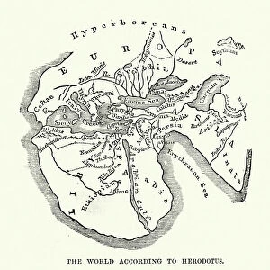
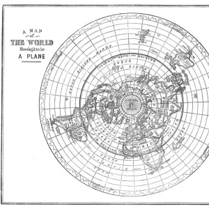
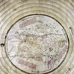
Premium Framed Print : WORLD MAP. Pre-Christian era, c450 B. C. according to the writings of Herodotus


![]()
Framed Photos from Granger
WORLD MAP. Pre-Christian era, c450 B. C. according to the writings of Herodotus
WORLD MAP. Pre-Christian era, c450 B.C. according to the writings of Herodotus. A 19th century reconstruction
Granger holds millions of images spanning more than 25,000 years of world history, from before the Stone Age to the dawn of the Space Age
Media ID 6617041
17"x15" (43x38cm) Premium Frame
FSC real wood frame with double mounted 10x8 print. Double mounted with white conservation mountboard. Frame moulding comprises stained composite natural wood veneers (Finger Jointed Pine) 39mm wide by 21mm thick. Archival quality Fujifilm CA photo paper mounted onto 1mm card. Overall outside dimensions are 17x15 inches (431x381mm). Rear features Framing tape to cover staples, 50mm Hanger plate, cork bumpers. Glazed with durable thick 2mm Acrylic to provide a virtually unbreakable glass-like finish. Acrylic Glass is far safer, more flexible and much lighter than typical mineral glass. Moreover, its higher translucency makes it a perfect carrier for photo prints. Acrylic allows a little more light to penetrate the surface than conventional glass and absorbs UV rays so that the image and the picture quality doesn't suffer under direct sunlight even after many years. Easily cleaned with a damp cloth. Please note that, to prevent the paper falling through the mount window and to prevent cropping of the original artwork, the visible print may be slightly smaller to allow the paper to be securely attached to the mount without any white edging showing and to match the aspect ratio of the original artwork.
FSC Real Wood Frame and Double Mounted with White Conservation Mountboard - Professionally Made and Ready to Hang
Estimated Image Size (if not cropped) is 24.4cm x 16.9cm (9.6" x 6.7")
Estimated Product Size is 43.1cm x 38.1cm (17" x 15")
These are individually made so all sizes are approximate
Artwork printed orientated as per the preview above, with landscape (horizontal) orientation to match the source image.
FEATURES IN THESE COLLECTIONS
> Granger Art on Demand
> Maps
> Arts
> Landscape paintings
> Waterfall and river artworks
> River artworks
> Maps and Charts
> Early Maps
> Maps and Charts
> Related Images
> Maps and Charts
> World
EDITORS COMMENTS
This print showcases a remarkable piece of history - the World Map from the Pre-Christian era, dating back to approximately 450 B. C. according to the writings of Herodotus. A true treasure for any history enthusiast, this 19th-century reconstruction offers a glimpse into ancient civilizations and their understanding of the world. The map depicts an intricate network of rivers, highlighting their significance as vital lifelines for early societies. It serves as a testament to human curiosity and exploration during that time period, providing valuable insights into how our ancestors perceived and navigated the globe. Every detail on this map tells a story - from the meandering rivers that snake through vast territories to the mysterious lands yet unexplored by ancient civilizations. The careful craftsmanship and attention to detail in this reproduction capture not only geographical accuracy but also evoke a sense of wonderment about our planet's past. As we gaze upon this extraordinary artifact, we are transported back in time, imagining ourselves alongside those intrepid explorers who sought knowledge beyond familiar horizons. This photograph is more than just an image; it is a gateway connecting us with our collective heritage. The Granger Collection has once again provided us with an invaluable window into history through this magnificent print. Whether displayed in homes or educational institutions, it serves as both an aesthetic centerpiece and an intellectual catalyst for conversations about humanity's journey across continents throughout millennia.
MADE IN THE UK
Safe Shipping with 30 Day Money Back Guarantee
FREE PERSONALISATION*
We are proud to offer a range of customisation features including Personalised Captions, Color Filters and Picture Zoom Tools
SECURE PAYMENTS
We happily accept a wide range of payment options so you can pay for the things you need in the way that is most convenient for you
* Options may vary by product and licensing agreement. Zoomed Pictures can be adjusted in the Basket.