Glass Frame > Arts > Landscape paintings > Waterfall and river artworks > River artworks
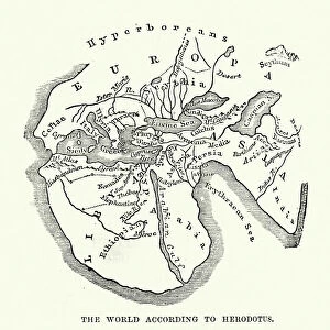
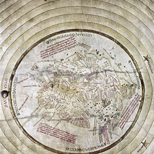
Glass Frame : WORLD MAP. Pre-Christian era, c450 B. C. according to the writings of Herodotus


![]()
Mounted Prints from Granger
WORLD MAP. Pre-Christian era, c450 B. C. according to the writings of Herodotus
WORLD MAP. Pre-Christian era, c450 B.C. according to the writings of Herodotus. A 19th century reconstruction
Granger holds millions of images spanning more than 25,000 years of world history, from before the Stone Age to the dawn of the Space Age
Media ID 6617041
7"x5" Glass Mount
Wall mounted or free-standing, these black edged glass frames feature a smooth chamfered edge and a stylish black border (on back face of the glass). Manufactured from 4mm thick glass, Glass Mounts are a durable, professional way of displaying and protecting your prints. Your 7x5 print is slotted into the back of the frame so can easily be changed if needed.
Tempered Glass Mounts are ideal for wall display, plus the smaller sizes can also be used free-standing via an integral stand
Estimated Image Size (if not cropped) is 17.7cm x 12.7cm (7" x 5")
Estimated Product Size is 20.3cm x 16.2cm (8" x 6.4")
These are individually made so all sizes are approximate
Artwork printed orientated as per the preview above, with landscape (horizontal) orientation to match the source image.
FEATURES IN THESE COLLECTIONS
> Arts
> Landscape paintings
> Waterfall and river artworks
> River artworks
> Maps and Charts
> Early Maps
> Maps and Charts
> Related Images
> Maps and Charts
> World
> Granger Art on Demand
> Maps
EDITORS COMMENTS
This print showcases a remarkable piece of history - the World Map from the Pre-Christian era, dating back to approximately 450 B. C. according to the writings of Herodotus. A true treasure for any history enthusiast, this 19th-century reconstruction offers a glimpse into ancient civilizations and their understanding of the world. The map depicts an intricate network of rivers, highlighting their significance as vital lifelines for early societies. It serves as a testament to human curiosity and exploration during that time period, providing valuable insights into how our ancestors perceived and navigated the globe. Every detail on this map tells a story - from the meandering rivers that snake through vast territories to the mysterious lands yet unexplored by ancient civilizations. The careful craftsmanship and attention to detail in this reproduction capture not only geographical accuracy but also evoke a sense of wonderment about our planet's past. As we gaze upon this extraordinary artifact, we are transported back in time, imagining ourselves alongside those intrepid explorers who sought knowledge beyond familiar horizons. This photograph is more than just an image; it is a gateway connecting us with our collective heritage. The Granger Collection has once again provided us with an invaluable window into history through this magnificent print. Whether displayed in homes or educational institutions, it serves as both an aesthetic centerpiece and an intellectual catalyst for conversations about humanity's journey across continents throughout millennia.
MADE IN THE UK
Safe Shipping with 30 Day Money Back Guarantee
FREE PERSONALISATION*
We are proud to offer a range of customisation features including Personalised Captions, Color Filters and Picture Zoom Tools
SECURE PAYMENTS
We happily accept a wide range of payment options so you can pay for the things you need in the way that is most convenient for you
* Options may vary by product and licensing agreement. Zoomed Pictures can be adjusted in the Basket.