Premium Framed Print > Arts > Landscape paintings > Waterfall and river artworks > River artworks
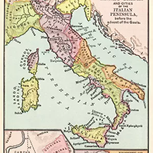
Premium Framed Print : AUSTRIAN EMPIRE MAP, 1795. Map of Prussia and the Austrian Empire as they appeared in the year 1795


![]()
Framed Photos from Granger
AUSTRIAN EMPIRE MAP, 1795. Map of Prussia and the Austrian Empire as they appeared in the year 1795
Granger holds millions of images spanning more than 25,000 years of world history, from before the Stone Age to the dawn of the Space Age
Media ID 6622527
1795 Austria Austrian Empire Prussia
17"x15" (43x38cm) Premium Frame
FSC real wood frame with double mounted 10x8 print. Double mounted with white conservation mountboard. Frame moulding comprises stained composite natural wood veneers (Finger Jointed Pine) 39mm wide by 21mm thick. Archival quality Fujifilm CA photo paper mounted onto 1mm card. Overall outside dimensions are 17x15 inches (431x381mm). Rear features Framing tape to cover staples, 50mm Hanger plate, cork bumpers. Glazed with durable thick 2mm Acrylic to provide a virtually unbreakable glass-like finish. Acrylic Glass is far safer, more flexible and much lighter than typical mineral glass. Moreover, its higher translucency makes it a perfect carrier for photo prints. Acrylic allows a little more light to penetrate the surface than conventional glass and absorbs UV rays so that the image and the picture quality doesn't suffer under direct sunlight even after many years. Easily cleaned with a damp cloth. Please note that, to prevent the paper falling through the mount window and to prevent cropping of the original artwork, the visible print may be slightly smaller to allow the paper to be securely attached to the mount without any white edging showing and to match the aspect ratio of the original artwork.
FSC Real Wood Frame and Double Mounted with White Conservation Mountboard - Professionally Made and Ready to Hang
Estimated Image Size (if not cropped) is 24.4cm x 19.4cm (9.6" x 7.6")
Estimated Product Size is 43.1cm x 38.1cm (17" x 15")
These are individually made so all sizes are approximate
Artwork printed orientated as per the preview above, with landscape (horizontal) orientation to match the source image.
FEATURES IN THESE COLLECTIONS
> Granger Art on Demand
> Maps
> Arts
> Landscape paintings
> Waterfall and river artworks
> River artworks
> Europe
> Austria
> Related Images
> Maps and Charts
> Related Images
EDITORS COMMENTS
This print showcases an exquisite map of the Austrian Empire and Prussia as they appeared in the year 1795. A true historical gem, this meticulously crafted piece takes us back to a time when empires reigned supreme and borders were defined by mighty rivers. The map beautifully illustrates the vast expanse of the Austrian Empire, stretching across Central Europe with its intricate network of territories and provinces. From Vienna to Budapest, from Bohemia to Transylvania, every corner is intricately detailed, giving us a glimpse into the immense power and influence that Austria once held. Adjacent to the Austrian Empire lies Prussia, another formidable force on the European stage during this era. The boundaries between these two great powers are clearly delineated on this map, showcasing their complex relationship and occasional conflicts throughout history. As we explore this historic artifact further, our eyes are drawn to the majestic rivers that meander through these lands - lifelines that have shaped civilizations for centuries. These waterways not only served as vital trade routes but also acted as natural barriers defining political boundaries. With its rich colors and precise cartographic details, this print from Granger Art on Demand transports us back in time. It serves as a reminder of how geography has played a pivotal role in shaping nations and empires throughout history.
MADE IN THE UK
Safe Shipping with 30 Day Money Back Guarantee
FREE PERSONALISATION*
We are proud to offer a range of customisation features including Personalised Captions, Color Filters and Picture Zoom Tools
SECURE PAYMENTS
We happily accept a wide range of payment options so you can pay for the things you need in the way that is most convenient for you
* Options may vary by product and licensing agreement. Zoomed Pictures can be adjusted in the Basket.