Premium Framed Print > Asia > Hong Kong > Maps
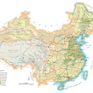
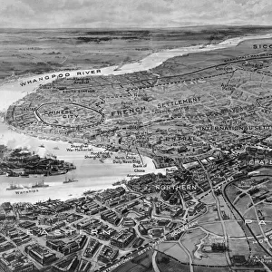
Premium Framed Print : China map. illustration of a South Eastern Asia map


![]()
Framed Photos from Fine Art Storehouse
China map. illustration of a South Eastern Asia map
Unleash your creativity and transform your space into a visual masterpiece!
Nastasic
Media ID 13750433
© This content is subject to copyright
Backgrounds Beijing Country Geographic Area Geographical Border Hong Kong India International Border Journey Macao Outline Shanghai Sichuan Province Silhouette Taiwan Tibet Topography Vector China East Asia Tianjin
17"x15" (43x38cm) Premium Frame
FSC real wood frame with double mounted 10x8 print. Double mounted with white conservation mountboard. Frame moulding comprises stained composite natural wood veneers (Finger Jointed Pine) 39mm wide by 21mm thick. Archival quality Fujifilm CA photo paper mounted onto 1mm card. Overall outside dimensions are 17x15 inches (431x381mm). Rear features Framing tape to cover staples, 50mm Hanger plate, cork bumpers. Glazed with durable thick 2mm Acrylic to provide a virtually unbreakable glass-like finish. Acrylic Glass is far safer, more flexible and much lighter than typical mineral glass. Moreover, its higher translucency makes it a perfect carrier for photo prints. Acrylic allows a little more light to penetrate the surface than conventional glass and absorbs UV rays so that the image and the picture quality doesn't suffer under direct sunlight even after many years. Easily cleaned with a damp cloth. Please note that, to prevent the paper falling through the mount window and to prevent cropping of the original artwork, the visible print may be slightly smaller to allow the paper to be securely attached to the mount without any white edging showing and to match the aspect ratio of the original artwork.
FSC Real Wood Frame and Double Mounted with White Conservation Mountboard - Professionally Made and Ready to Hang
Estimated Image Size (if not cropped) is 24.4cm x 19.2cm (9.6" x 7.6")
Estimated Product Size is 43.1cm x 38.1cm (17" x 15")
These are individually made so all sizes are approximate
Artwork printed orientated as per the preview above, with landscape (horizontal) orientation to match the source image.
FEATURES IN THESE COLLECTIONS
> Fine Art Storehouse
> Map
> Historical Maps
> Fine Art Storehouse
> Top Sellers - Art Prints
> Asia
> China
> Lakes
> Related Images
> Asia
> Hong Kong
> Related Images
> Asia
> India
> Lakes
> Related Images
EDITORS COMMENTS
This print showcases the intricate beauty of a China map, capturing the essence of South Eastern Asia. Created by talented artist Nastasic, this horizontal illustration takes viewers on a visual journey through the diverse landscapes and iconic landmarks that define this vast country. From the bustling cities of Shanghai and Beijing to the serene mountain ranges and lakes, every detail is meticulously engraved in this stunning piece. The silhouette-like design adds an element of mystery and intrigue, inviting viewers to explore further. The map includes significant regions such as Macao, Taiwan, Tianjin, Sichuan Province, Hong Kong, Tibet, India, and more. It also highlights international borders with precision while showcasing topographical features like hills and mountains. The use of vector graphics enhances the clarity and depth of this artwork while maintaining its artistic integrity. With no people present in the image itself, it allows us to focus solely on appreciating China's natural beauty from a geographical perspective. Perfect for travel enthusiasts or those fascinated by cartography or physical geography alike; this print serves as both an educational tool and a decorative piece. Whether displayed in homes or offices around the world - it will undoubtedly inspire wanderlust for all who lay eyes upon it.
MADE IN THE UK
Safe Shipping with 30 Day Money Back Guarantee
FREE PERSONALISATION*
We are proud to offer a range of customisation features including Personalised Captions, Color Filters and Picture Zoom Tools
SECURE PAYMENTS
We happily accept a wide range of payment options so you can pay for the things you need in the way that is most convenient for you
* Options may vary by product and licensing agreement. Zoomed Pictures can be adjusted in the Basket.