Premium Framed Print > Historic > Ancient civilizations > Roman Empire > Ancient Rome
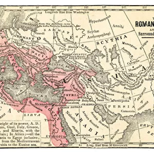
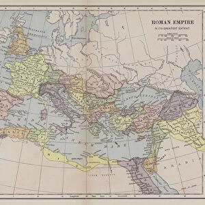
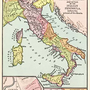
Premium Framed Print : Illustrated map of Roman Empire, BC


![]()
Framed Photos from Fine Art Storehouse
Illustrated map of Roman Empire, BC
Unleash your creativity and transform your space into a visual masterpiece!
Dorling Kindersley
Media ID 13540757
© This content is subject to copyright
Ancient History Ancient Rome Background People Empire Geography Illustrated Map Incidental People Roman Watercolour Painting
17"x15" (43x38cm) Premium Frame
FSC real wood frame with double mounted 10x8 print. Double mounted with white conservation mountboard. Frame moulding comprises stained composite natural wood veneers (Finger Jointed Pine) 39mm wide by 21mm thick. Archival quality Fujifilm CA photo paper mounted onto 1mm card. Overall outside dimensions are 17x15 inches (431x381mm). Rear features Framing tape to cover staples, 50mm Hanger plate, cork bumpers. Glazed with durable thick 2mm Acrylic to provide a virtually unbreakable glass-like finish. Acrylic Glass is far safer, more flexible and much lighter than typical mineral glass. Moreover, its higher translucency makes it a perfect carrier for photo prints. Acrylic allows a little more light to penetrate the surface than conventional glass and absorbs UV rays so that the image and the picture quality doesn't suffer under direct sunlight even after many years. Easily cleaned with a damp cloth. Please note that, to prevent the paper falling through the mount window and to prevent cropping of the original artwork, the visible print may be slightly smaller to allow the paper to be securely attached to the mount without any white edging showing and to match the aspect ratio of the original artwork.
FSC Real Wood Frame and Double Mounted with White Conservation Mountboard - Professionally Made and Ready to Hang
Estimated Image Size (if not cropped) is 24.4cm x 19.8cm (9.6" x 7.8")
Estimated Product Size is 43.1cm x 38.1cm (17" x 15")
These are individually made so all sizes are approximate
Artwork printed orientated as per the preview above, with landscape (horizontal) orientation to match the source image.
FEATURES IN THESE COLLECTIONS
> Fine Art Storehouse
> Photo Libraries
> Dorling Kindersley Prints
> Arts
> Artists
> R
> Roman Roman
> Arts
> Still life artwork
> Watercolor paintings
> Fine art
> Arts
> Watercolor paintings
> Watercolor illustrations
> Europe
> Italy
> Lazio
> Rome
> Europe
> Related Images
> Historic
> Ancient civilizations
> Roman Empire
> Ancient Rome
> Historic
> Ancient civilizations
> Roman Empire
> Roman art
> Maps and Charts
> Early Maps
> Maps and Charts
> Related Images
EDITORS COMMENTS
This print showcases an exquisitely detailed illustrated map of the Roman Empire during ancient times. Created by Dorling Kindersley, this watercolor painting beautifully captures the vastness and complexity of one of history's greatest empires. The artist's meticulous attention to detail is evident in every stroke, bringing to life the intricate geography and physical features that defined the empire. Set against a pristine white background, this horizontal artwork invites viewers to immerse themselves in a journey through time. From Europe to distant lands, the expansive reach of Rome unfolds before our eyes. The vibrant colors used in this watercolor painting add depth and richness to each region depicted on the map. Intriguingly, amidst this historical panorama are subtle hints of everyday life - incidental people going about their daily activities - reminding us that behind grand empires lie ordinary individuals who shaped its destiny. Whether you're a history enthusiast or simply appreciate fine artistry, this print offers an opportunity for exploration and discovery. It serves as both an educational tool and a stunning decorative piece for any space. Let your imagination wander as you trace ancient trade routes or envision epic battles fought on these very lands. With its timeless appeal and undeniable beauty, "Illustrated Map of Roman Empire" transports us back in time while simultaneously enriching our understanding of one of civilization's most influential periods.
MADE IN THE UK
Safe Shipping with 30 Day Money Back Guarantee
FREE PERSONALISATION*
We are proud to offer a range of customisation features including Personalised Captions, Color Filters and Picture Zoom Tools
SECURE PAYMENTS
We happily accept a wide range of payment options so you can pay for the things you need in the way that is most convenient for you
* Options may vary by product and licensing agreement. Zoomed Pictures can be adjusted in the Basket.