Premium Framed Print > Aerial Photography > Related Images
Premium Framed Print : West Valley City Utah US City Street Map


![]()
Framed Photos from Fine Art Storehouse
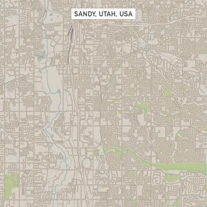
West Valley City Utah US City Street Map
Vector Illustration of a City Street Map of West Valley City, Utah, USA. Scale 1:60, 000.
All source data is in the public domain.
U.S. Geological Survey, US Topo
Used Layers:
USGS The National Map: National Hydrography Dataset (NHD)
USGS The National Map: National Transportation Dataset (NTD)
Unleash your creativity and transform your space into a visual masterpiece!
Frank Ramspott
Media ID 15054967
© Frank Ramspott, all rights reserved
Aerial View City Map Computer Graphic Directly Above Downtown District Gray Road Map Text Utah Digitally Generated Image Green Color White Color
31"x27" (79x69cm) Premium Frame
FSC real wood frame with double mounted 24x20 print. Double mounted with white conservation mountboard. Frame moulding comprises stained composite natural wood veneers (Finger Jointed Pine) 39mm wide by 21mm thick. Archival quality Fujifilm CA photo paper mounted onto 1mm card. Overall outside dimensions are 31x27 inches (787x685mm). Rear features Framing tape to cover staples, 50mm Hanger plate, cork bumpers. Glazed with durable thick 2mm Acrylic to provide a virtually unbreakable glass-like finish. Acrylic Glass is far safer, more flexible and much lighter than typical mineral glass. Moreover, its higher translucency makes it a perfect carrier for photo prints. Acrylic allows a little more light to penetrate the surface than conventional glass and absorbs UV rays so that the image and the picture quality doesn't suffer under direct sunlight even after many years. Easily cleaned with a damp cloth. Please note that, to prevent the paper falling through the mount window and to prevent cropping of the original artwork, the visible print may be slightly smaller to allow the paper to be securely attached to the mount without any white edging showing and to match the aspect ratio of the original artwork.
FSC Real Wood Frame and Double Mounted with White Conservation Mountboard - Professionally Made and Ready to Hang
Estimated Image Size (if not cropped) is 59.9cm x 59.9cm (23.6" x 23.6")
Estimated Product Size is 68.5cm x 78.7cm (27" x 31")
These are individually made so all sizes are approximate
Artwork printed orientated as per the preview above, with landscape (horizontal) or portrait (vertical) orientation to match the source image.
FEATURES IN THESE COLLECTIONS
> Fine Art Storehouse
> Map
> Street Maps
> Fine Art Storehouse
> Map
> USA Maps
> Aerial Photography
> Related Images
> Animals
> Insects
> Hemiptera
> Green Scale
> Arts
> Contemporary art
> Digital artwork
> Street art
> Arts
> Landscape paintings
> Waterfall and river artworks
> River artworks
> Arts
> Portraits
> Pop art gallery
> Street art portraits
> Arts
> Street art graffiti
> Digital art
> Digital paintings
> Arts
> Street art graffiti
> Digital art
> Vector illustrations
> Maps and Charts
> Geological Map
> Maps and Charts
> Related Images
> North America
> United States of America
> Lakes
> Related Images
EDITORS COMMENTS
This print showcases the intricate details of West Valley City, Utah's city street map. With a scale of 1:60,000, every road and district is meticulously illustrated in this vector illustration. The image highlights the downtown area with its bustling streets, surrounded by a serene lake and river that add to the city's charm. The source data used for this artwork is from the public domain, specifically obtained from U. S. Geological Survey's National Hydrography Dataset (NHD) and National Transportation Dataset (NTD). These layers provide accurate information about the hydrography and transportation network within West Valley City. The digitally generated image presents an aerial view directly above the city, allowing viewers to appreciate its layout and organization. The color palette includes shades of gray, blue, white, and green which beautifully represent both physical geography elements and cartographic design. Frank Ramspott skillfully brings this map to life through computer graphics without including any people in order to focus solely on showcasing the city's infrastructure. This stunning piece serves as a testament to Ramspott's talent as an artist while also providing valuable geographic information for those interested in exploring or studying West Valley City.
MADE IN THE UK
Safe Shipping with 30 Day Money Back Guarantee
FREE PERSONALISATION*
We are proud to offer a range of customisation features including Personalised Captions, Color Filters and Picture Zoom Tools
SECURE PAYMENTS
We happily accept a wide range of payment options so you can pay for the things you need in the way that is most convenient for you
* Options may vary by product and licensing agreement. Zoomed Pictures can be adjusted in the Basket.