Premium Framed Print > Europe > Related Images
Premium Framed Print : Satellite Map of Europe with Hurricane


![]()
Framed Photos from Fine Art Storehouse
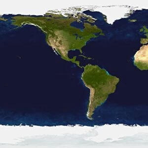
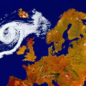
Satellite Map of Europe with Hurricane
SATELLITE MAP OF EUROPE WITH HURRICANE, Satellite Maps, 217403
Unleash your creativity and transform your space into a visual masterpiece!
GSO Images
Media ID 14833521
© This content is subject to copyright
23"x19" (58x48cm) Premium Frame
FSC real wood frame with double mounted 16x12 print. Double mounted with white conservation mountboard. Frame moulding comprises stained composite natural wood veneers (Finger Jointed Pine) 39mm wide by 21mm thick. Archival quality Fujifilm CA photo paper mounted onto 1mm card. Overall outside dimensions are 23x19 inches (584x482mm). Rear features Framing tape to cover staples, 50mm Hanger plate, cork bumpers. Glazed with durable thick 2mm Acrylic to provide a virtually unbreakable glass-like finish. Acrylic Glass is far safer, more flexible and much lighter than typical mineral glass. Moreover, its higher translucency makes it a perfect carrier for photo prints. Acrylic allows a little more light to penetrate the surface than conventional glass and absorbs UV rays so that the image and the picture quality doesn't suffer under direct sunlight even after many years. Easily cleaned with a damp cloth. Please note that, to prevent the paper falling through the mount window and to prevent cropping of the original artwork, the visible print may be slightly smaller to allow the paper to be securely attached to the mount without any white edging showing and to match the aspect ratio of the original artwork.
FSC Real Wood Frame and Double Mounted with White Conservation Mountboard - Professionally Made and Ready to Hang
Estimated Image Size (if not cropped) is 26.1cm x 39.6cm (10.3" x 15.6")
Estimated Product Size is 48.2cm x 58.4cm (19" x 23")
These are individually made so all sizes are approximate
Artwork printed orientated as per the preview above, with portrait (vertical) orientation to match the source image.
FEATURES IN THESE COLLECTIONS
> Fine Art Storehouse
> Map
> Satellite Maps
> Europe
> Related Images
> Maps and Charts
> Related Images
EDITORS COMMENTS
This print titled "Satellite Map of Europe with Hurricane" takes us on a mesmerizing journey above the European continent, showcasing the intricate beauty and power of nature. The image captures a satellite's view of Europe, revealing its diverse landscapes, cities, and coastlines. However, what truly steals the spotlight is an awe-inspiring hurricane swirling over a portion of this vast region. The hurricane's presence creates a stark contrast against the otherwise serene backdrop. Its spiral shape dominates the frame as it unleashes its might upon land and sea alike. The vibrant colors used in this artwork further enhance our perception of this natural phenomenon; shades of deep blues and grays evoke feelings of both awe and trepidation. Through this photograph, we are reminded that even amidst civilization's advancements, Mother Nature remains an unstoppable force capable of shaping our world in ways beyond human control. It serves as a humbling reminder that despite our progress, we are still subject to her whims. This fine art print by GSO Images not only showcases their exceptional talent for capturing breathtaking scenes but also invites viewers to reflect on humanity's place within nature's grand design. Whether displayed in homes or offices, this piece will undoubtedly spark conversations about climate change, resilience, and mankind's relationship with the environment – making it an ideal addition to any art collection seeking to inspire contemplation and awareness.
MADE IN THE UK
Safe Shipping with 30 Day Money Back Guarantee
FREE PERSONALISATION*
We are proud to offer a range of customisation features including Personalised Captions, Color Filters and Picture Zoom Tools
SECURE PAYMENTS
We happily accept a wide range of payment options so you can pay for the things you need in the way that is most convenient for you
* Options may vary by product and licensing agreement. Zoomed Pictures can be adjusted in the Basket.