Premium Framed Print > Maps and Charts > World
Premium Framed Print : world map 1883


![]()
Framed Photos from Fine Art Storehouse
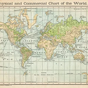
world map 1883
map of the world - 1883
Unleash your creativity and transform your space into a visual masterpiece!
THEPALMER
Media ID 21177755
© Roberto A Sanchez
Atlas Earth Globe Map03 Retro Revival World Map
17"x15" (43x38cm) Premium Frame
FSC real wood frame with double mounted 10x8 print. Double mounted with white conservation mountboard. Frame moulding comprises stained composite natural wood veneers (Finger Jointed Pine) 39mm wide by 21mm thick. Archival quality Fujifilm CA photo paper mounted onto 1mm card. Overall outside dimensions are 17x15 inches (431x381mm). Rear features Framing tape to cover staples, 50mm Hanger plate, cork bumpers. Glazed with durable thick 2mm Acrylic to provide a virtually unbreakable glass-like finish. Acrylic Glass is far safer, more flexible and much lighter than typical mineral glass. Moreover, its higher translucency makes it a perfect carrier for photo prints. Acrylic allows a little more light to penetrate the surface than conventional glass and absorbs UV rays so that the image and the picture quality doesn't suffer under direct sunlight even after many years. Easily cleaned with a damp cloth. Please note that, to prevent the paper falling through the mount window and to prevent cropping of the original artwork, the visible print may be slightly smaller to allow the paper to be securely attached to the mount without any white edging showing and to match the aspect ratio of the original artwork.
FSC Real Wood Frame and Double Mounted with White Conservation Mountboard - Professionally Made and Ready to Hang
Estimated Image Size (if not cropped) is 24.4cm x 20cm (9.6" x 7.9")
Estimated Product Size is 43.1cm x 38.1cm (17" x 15")
These are individually made so all sizes are approximate
Artwork printed orientated as per the preview above, with landscape (horizontal) orientation to match the source image.
FEATURES IN THESE COLLECTIONS
> Fine Art Storehouse
> Map
> Historical Maps
> Maps and Charts
> Related Images
> Maps and Charts
> World
EDITORS COMMENTS
In this print titled "World Map 1883" we are transported back in time to an era of exploration and discovery. The map, meticulously crafted by cartographers of the past, showcases a world that is both familiar and yet vastly different from our own. With its retro revival aesthetic, this antique piece evokes a sense of nostalgia for the golden age of atlas-making. The physical geography depicted on this old-fashioned globe reminds us of the intricate interconnectedness of our planet's landmasses and oceans. It serves as a reminder that despite our diverse cultures and vast distances between us, we all share one Earth. "The World Map 1883" invites viewers to embark on a journey through history, tracing the footsteps of explorers who ventured into uncharted territories. This stunning artwork captures not only geographical details but also sparks curiosity about the stories behind each place name etched onto its surface. THEPALMER's masterful capture ensures that every minute detail is preserved with utmost clarity, allowing us to appreciate the artistry involved in creating such an exquisite map. Whether displayed in homes or offices, this print adds a touch of sophistication while igniting conversations about our planet's rich heritage. Immerse yourself in this timeless piece and let your imagination wander across continents as you explore the intricacies and beauty captured within "World Map 1883. "
MADE IN THE UK
Safe Shipping with 30 Day Money Back Guarantee
FREE PERSONALISATION*
We are proud to offer a range of customisation features including Personalised Captions, Color Filters and Picture Zoom Tools
SECURE PAYMENTS
We happily accept a wide range of payment options so you can pay for the things you need in the way that is most convenient for you
* Options may vary by product and licensing agreement. Zoomed Pictures can be adjusted in the Basket.