Premium Framed Print > Asia > Palestine > Maps
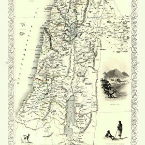
Premium Framed Print : Map of Palestine 1896


![]()
Framed Photos From Fine Art Storehouse
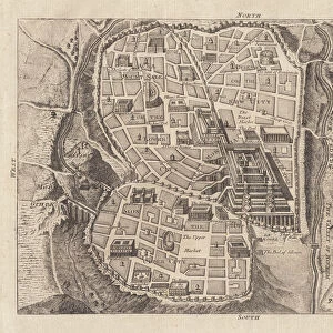
Map of Palestine 1896
Andres Allgemeiner Handatlas - Bielefeld und Leipzig 1896
Unleash your creativity and transform your space into a visual masterpiece!
THEPALMER
Media ID 18356853
23"x19" (58x48cm) Premium Frame
FSC real wood frame with double mounted 16x12 print. Double mounted with white conservation mountboard. Frame moulding comprises stained composite natural wood veneers (Finger Jointed Pine) 39mm wide by 21mm thick. Archival quality Fujifilm CA photo paper mounted onto 1mm card. Overall outside dimensions are 23x19 inches (584x482mm). Rear features Framing tape to cover staples, 50mm Hanger plate, cork bumpers. Glazed with durable thick 2mm Acrylic to provide a virtually unbreakable glass-like finish. Acrylic Glass is far safer, more flexible and much lighter than typical mineral glass. Moreover, its higher translucency makes it a perfect carrier for photo prints. Acrylic allows a little more light to penetrate the surface than conventional glass and absorbs UV rays so that the image and the picture quality doesn't suffer under direct sunlight even after many years. Easily cleaned with a damp cloth. Please note that, to prevent the paper falling through the mount window and to prevent cropping of the original artwork, the visible print may be slightly smaller to allow the paper to be securely attached to the mount without any white edging showing and to match the aspect ratio of the original artwork.
FSC Real Wood Frame and Double Mounted with White Conservation Mountboard - Professionally Made and Ready to Hang
Estimated Image Size (if not cropped) is 26.7cm x 39.6cm (10.5" x 15.6")
Estimated Product Size is 48.2cm x 58.4cm (19" x 23")
These are individually made so all sizes are approximate
Artwork printed orientated as per the preview above, with portrait (vertical) orientation to match the source image.
FEATURES IN THESE COLLECTIONS
> Fine Art Storehouse
> Map
> Historical Maps
> Asia
> Palestine
> Related Images
> Maps and Charts
> Related Images
EDITORS COMMENTS
In this print titled "Map of Palestine 1896" we are transported back in time to the late 19th century. The image showcases a meticulously detailed map from Andres Allgemeiner Handatlas, published in Bielefeld und Leipzig in 1896. As we delve into the intricacies of this historical artifact, our eyes are drawn to the rich tapestry of information it holds. The map itself is a testament to cartographic artistry, with its delicate lines and precise labeling capturing the essence of Palestine during that era. It offers a window into a bygone world, where borders were different and territories held distinct identities. Through this visual representation, we gain insights into how people perceived and understood geography over a century ago. Every corner of this vintage map tells stories waiting to be explored - ancient cities dotting the landscape, rivers meandering through lush valleys, and mountains standing tall as silent witnesses to centuries past. It serves as an invaluable resource for historians, geographers, or anyone seeking knowledge about Palestine's geographical layout at that particular moment in history. "The Map of Palestine 1896" print by THEPALMER available at Fine Art Storehouse not only preserves an important piece of cartographic heritage but also invites us on an enchanting journey through time. Whether displayed on walls or cherished within personal collections, it sparks curiosity and fosters appreciation for both artistry and history alike
MADE IN THE UK
Safe Shipping with 30 Day Money Back Guarantee
FREE PERSONALISATION*
We are proud to offer a range of customisation features including Personalised Captions, Color Filters and Picture Zoom Tools
SECURE PAYMENTS
We happily accept a wide range of payment options so you can pay for the things you need in the way that is most convenient for you
* Options may vary by product and licensing agreement. Zoomed Pictures can be adjusted in the Basket.