Premium Framed Print > Asia > India > Maps
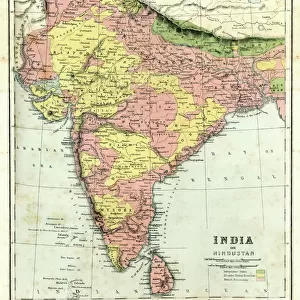
Premium Framed Print : Map of India and Central Asia 1896


![]()
Framed Photos From Fine Art Storehouse
Map of India and Central Asia 1896
Andres Allgemeiner Handatlas - Bielefeld und Leipzig 1896
Unleash your creativity and transform your space into a visual masterpiece!
THEPALMER
Media ID 18356839
17"x15" (43x38cm) Premium Frame
FSC real wood frame with double mounted 10x8 print. Double mounted with white conservation mountboard. Frame moulding comprises stained composite natural wood veneers (Finger Jointed Pine) 39mm wide by 21mm thick. Archival quality Fujifilm CA photo paper mounted onto 1mm card. Overall outside dimensions are 17x15 inches (431x381mm). Rear features Framing tape to cover staples, 50mm Hanger plate, cork bumpers. Glazed with durable thick 2mm Acrylic to provide a virtually unbreakable glass-like finish. Acrylic Glass is far safer, more flexible and much lighter than typical mineral glass. Moreover, its higher translucency makes it a perfect carrier for photo prints. Acrylic allows a little more light to penetrate the surface than conventional glass and absorbs UV rays so that the image and the picture quality doesn't suffer under direct sunlight even after many years. Easily cleaned with a damp cloth. Please note that, to prevent the paper falling through the mount window and to prevent cropping of the original artwork, the visible print may be slightly smaller to allow the paper to be securely attached to the mount without any white edging showing and to match the aspect ratio of the original artwork.
FSC Real Wood Frame and Double Mounted with White Conservation Mountboard - Professionally Made and Ready to Hang
Estimated Image Size (if not cropped) is 19.2cm x 24.4cm (7.6" x 9.6")
Estimated Product Size is 38.1cm x 43.1cm (15" x 17")
These are individually made so all sizes are approximate
Artwork printed orientated as per the preview above, with portrait (vertical) orientation to match the source image.
FEATURES IN THESE COLLECTIONS
> Fine Art Storehouse
> Map
> Historical Maps
> Asia
> India
> Related Images
> Maps and Charts
> India
> Maps and Charts
> Related Images
EDITORS COMMENTS
This print showcases a vintage map titled "Map of India and Central Asia 1896" sourced from Andres Allgemeiner Handatlas - Bielefeld und Leipzig 1896. A true gem for history enthusiasts, this piece takes us back to the late 19th century, offering a glimpse into the intricate cartographic knowledge of that era. The map itself is a testament to the artistry and precision involved in creating such detailed representations before modern technology took over. With its delicate lines and meticulous labeling, it invites viewers on an exploratory journey through the vast territories of India and Central Asia as they existed more than a century ago. As we delve into this visual treasure trove, we can trace ancient trade routes, discover forgotten cities, and marvel at the diverse topography that defines these regions. From the majestic peaks of the Himalayas to the sprawling deserts of Rajasthan, every contour tells a story waiting to be unraveled. Beyond its historical significance lies an aesthetic appeal that adds charm to any space it graces. The warm sepia tones evoke nostalgia while enhancing its antique allure. Whether displayed in homes or offices, this print by THEPALMER from Fine Art Storehouse serves as both an educational tool and a conversation starter. Allow yourself to get lost in time with this remarkable artwork – let your imagination wander across borders and immerse yourself in an era long gone but forever preserved within this stunning depiction of India and Central Asia's past.
MADE IN THE UK
Safe Shipping with 30 Day Money Back Guarantee
FREE PERSONALISATION*
We are proud to offer a range of customisation features including Personalised Captions, Color Filters and Picture Zoom Tools
SECURE PAYMENTS
We happily accept a wide range of payment options so you can pay for the things you need in the way that is most convenient for you
* Options may vary by product and licensing agreement. Zoomed Pictures can be adjusted in the Basket.