Premium Framed Print > Historic > Ancient civilizations > Ancient Greece > Greek history
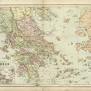
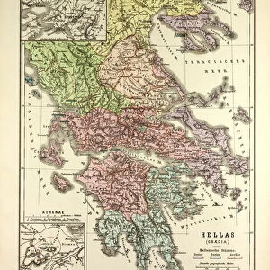
Premium Framed Print : Map of Greece 1896


![]()
Framed Photos from Fine Art Storehouse
Map of Greece 1896
Andres Allgemeiner Handatlas - Bielefeld und Leipzig 1896
Unleash your creativity and transform your space into a visual masterpiece!
THEPALMER
Media ID 18356861
23"x19" (58x48cm) Premium Frame
FSC real wood frame with double mounted 16x12 print. Double mounted with white conservation mountboard. Frame moulding comprises stained composite natural wood veneers (Finger Jointed Pine) 39mm wide by 21mm thick. Archival quality Fujifilm CA photo paper mounted onto 1mm card. Overall outside dimensions are 23x19 inches (584x482mm). Rear features Framing tape to cover staples, 50mm Hanger plate, cork bumpers. Glazed with durable thick 2mm Acrylic to provide a virtually unbreakable glass-like finish. Acrylic Glass is far safer, more flexible and much lighter than typical mineral glass. Moreover, its higher translucency makes it a perfect carrier for photo prints. Acrylic allows a little more light to penetrate the surface than conventional glass and absorbs UV rays so that the image and the picture quality doesn't suffer under direct sunlight even after many years. Easily cleaned with a damp cloth. Please note that, to prevent the paper falling through the mount window and to prevent cropping of the original artwork, the visible print may be slightly smaller to allow the paper to be securely attached to the mount without any white edging showing and to match the aspect ratio of the original artwork.
FSC Real Wood Frame and Double Mounted with White Conservation Mountboard - Professionally Made and Ready to Hang
Estimated Image Size (if not cropped) is 39.6cm x 26.2cm (15.6" x 10.3")
Estimated Product Size is 58.4cm x 48.2cm (23" x 19")
These are individually made so all sizes are approximate
Artwork printed orientated as per the preview above, with landscape (horizontal) orientation to match the source image.
FEATURES IN THESE COLLECTIONS
> Fine Art Storehouse
> Map
> Historical Maps
> Europe
> Greece
> Related Images
> Historic
> Ancient civilizations
> Ancient Greece
> Greek history
> Maps and Charts
> Related Images
EDITORS COMMENTS
This print showcases a rare gem from the past, presenting the "Map of Greece 1896" as depicted in Andres Allgemeiner Handatlas - Bielefeld und Leipzig 1896. A true testament to historical cartography, this piece takes us back to a time when maps were meticulously crafted by hand and served as gateways to unexplored territories. The intricate details of this map transport us to late 19th-century Greece, offering a glimpse into its rich cultural heritage and geographical marvels. From the rugged mountain ranges that dominate its landscape to the meandering rivers that shape its valleys, every contour is beautifully captured on this vintage masterpiece. As we delve deeper into this artwork, our eyes are drawn towards significant landmarks such as Athens with its iconic Acropolis standing tall amidst bustling city life. The ancient ruins scattered across the land remind us of Greece's profound influence on Western civilization and evoke an undeniable sense of awe. Expertly preserved by THEPALMER, this print allows us to appreciate not only the artistry behind historical mapping but also serves as a reminder of how far we have come in terms of technological advancements. It invites us to reflect upon our own place in history while celebrating the enduring beauty and timeless allure of Greece.
MADE IN THE UK
Safe Shipping with 30 Day Money Back Guarantee
FREE PERSONALISATION*
We are proud to offer a range of customisation features including Personalised Captions, Color Filters and Picture Zoom Tools
SECURE PAYMENTS
We happily accept a wide range of payment options so you can pay for the things you need in the way that is most convenient for you
* Options may vary by product and licensing agreement. Zoomed Pictures can be adjusted in the Basket.