Fine Art Print > Historic > Ancient civilizations > Ancient Greece > Greek history
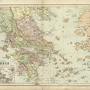
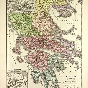
Fine Art Print : Map of Greece 1896


![]()
Fine Art Prints from Fine Art Storehouse
Map of Greece 1896
Andres Allgemeiner Handatlas - Bielefeld und Leipzig 1896
Unleash your creativity and transform your space into a visual masterpiece!
THEPALMER
Media ID 18356861
A2 (42x59cm) Fine Art Print
Discover the rich history and culture of Greece with this exquisite Map of Greece from THEPALMER, available in the Media Storehouse range of Fine Art Prints. Originally published in the Andres Allgemeiner Handatlas of 1896 from Bielefeld and Leipzig, this vintage map offers a captivating glimpse into the past. With intricate detail and beautiful cartography, this print makes a stunning addition to any home or office, transporting you to the heart of ancient civilizations and timeless beauty. Bring a piece of history into your space and elevate your decor with this fine art print from Media Storehouse.
Our Fine Art Prints are printed on 100% acid free, PH neutral paper with archival properties. This printing method is used by museums and art collections to exhibit photographs and art reproductions. Hahnemühle certified studio for digital fine art printing. Printed on 308gsm Photo Rag Paper.
Our fine art prints are high-quality prints made using a paper called Photo Rag. This 100% cotton rag fibre paper is known for its exceptional image sharpness, rich colors, and high level of detail, making it a popular choice for professional photographers and artists. Photo rag paper is our clear recommendation for a fine art paper print. If you can afford to spend more on a higher quality paper, then Photo Rag is our clear recommendation for a fine art paper print.
Estimated Image Size (if not cropped) is 59.4cm x 39.3cm (23.4" x 15.5")
Estimated Product Size is 59.4cm x 42cm (23.4" x 16.5")
These are individually made so all sizes are approximate
Artwork printed orientated as per the preview above, with landscape (horizontal) orientation to match the source image.
FEATURES IN THESE COLLECTIONS
> Europe
> Greece
> Related Images
> Historic
> Ancient civilizations
> Ancient Greece
> Greek history
> Maps and Charts
> Related Images
> Fine Art Storehouse
> Map
> Historical Maps
EDITORS COMMENTS
This print showcases a rare gem from the past, presenting the "Map of Greece 1896" as depicted in Andres Allgemeiner Handatlas - Bielefeld und Leipzig 1896. A true testament to historical cartography, this piece takes us back to a time when maps were meticulously crafted by hand and served as gateways to unexplored territories. The intricate details of this map transport us to late 19th-century Greece, offering a glimpse into its rich cultural heritage and geographical marvels. From the rugged mountain ranges that dominate its landscape to the meandering rivers that shape its valleys, every contour is beautifully captured on this vintage masterpiece. As we delve deeper into this artwork, our eyes are drawn towards significant landmarks such as Athens with its iconic Acropolis standing tall amidst bustling city life. The ancient ruins scattered across the land remind us of Greece's profound influence on Western civilization and evoke an undeniable sense of awe. Expertly preserved by THEPALMER, this print allows us to appreciate not only the artistry behind historical mapping but also serves as a reminder of how far we have come in terms of technological advancements. It invites us to reflect upon our own place in history while celebrating the enduring beauty and timeless allure of Greece.
MADE IN THE UK
Safe Shipping with 30 Day Money Back Guarantee
FREE PERSONALISATION*
We are proud to offer a range of customisation features including Personalised Captions, Color Filters and Picture Zoom Tools
SECURE PAYMENTS
We happily accept a wide range of payment options so you can pay for the things you need in the way that is most convenient for you
* Options may vary by product and licensing agreement. Zoomed Pictures can be adjusted in the Basket.