Premium Framed Print > Europe > Germany > Maps
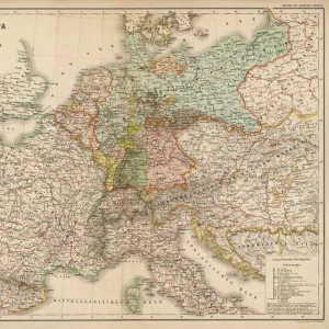
Premium Framed Print : Map of Germany 1889


![]()
Framed Photos from Fine Art Storehouse
Map of Germany 1889
Comprehensive Geography by James Monteith - American Book Company 1882, 1889
Unleash your creativity and transform your space into a visual masterpiece!
THEPALMER
Media ID 18357299
17"x15" (43x38cm) Premium Frame
FSC real wood frame with double mounted 10x8 print. Double mounted with white conservation mountboard. Frame moulding comprises stained composite natural wood veneers (Finger Jointed Pine) 39mm wide by 21mm thick. Archival quality Fujifilm CA photo paper mounted onto 1mm card. Overall outside dimensions are 17x15 inches (431x381mm). Rear features Framing tape to cover staples, 50mm Hanger plate, cork bumpers. Glazed with durable thick 2mm Acrylic to provide a virtually unbreakable glass-like finish. Acrylic Glass is far safer, more flexible and much lighter than typical mineral glass. Moreover, its higher translucency makes it a perfect carrier for photo prints. Acrylic allows a little more light to penetrate the surface than conventional glass and absorbs UV rays so that the image and the picture quality doesn't suffer under direct sunlight even after many years. Easily cleaned with a damp cloth. Please note that, to prevent the paper falling through the mount window and to prevent cropping of the original artwork, the visible print may be slightly smaller to allow the paper to be securely attached to the mount without any white edging showing and to match the aspect ratio of the original artwork.
FSC Real Wood Frame and Double Mounted with White Conservation Mountboard - Professionally Made and Ready to Hang
Estimated Image Size (if not cropped) is 24.4cm x 21.6cm (9.6" x 8.5")
Estimated Product Size is 43.1cm x 38.1cm (17" x 15")
These are individually made so all sizes are approximate
Artwork printed orientated as per the preview above, with landscape (horizontal) orientation to match the source image.
FEATURES IN THESE COLLECTIONS
> Fine Art Storehouse
> Map
> Historical Maps
> Europe
> Germany
> Related Images
> Maps and Charts
> Related Images
EDITORS COMMENTS
In this print titled "Map of Germany 1889" we are transported back in time to the late 19th century, when cartography was a meticulous art form. The map, sourced from James Monteith's renowned Comprehensive Geography published by the American Book Company in 1882 and updated in 1889, offers us a glimpse into the intricate details of Germany's geography during that era. The expert craftsmanship is evident as we observe every delicate line and carefully chosen color palette that brings this historical map to life. From the majestic peaks of the Bavarian Alps to the meandering rivers like the Rhine and Danube, each feature is meticulously rendered with precision and accuracy. As we explore this vintage treasure, it becomes apparent how much has changed over time. We can trace borders that have shifted due to political transformations while discovering cities whose names might have evolved or faded away entirely. This snapshot of history not only serves as an educational tool but also sparks our imagination about what life was like for those who inhabited these lands more than a century ago. "The Map of Germany 1889" by THEPALMER captures both nostalgia and curiosity within its frame. It reminds us of our ever-changing world while preserving a moment frozen in time—a testament to human ingenuity and exploration through cartography.
MADE IN THE UK
Safe Shipping with 30 Day Money Back Guarantee
FREE PERSONALISATION*
We are proud to offer a range of customisation features including Personalised Captions, Color Filters and Picture Zoom Tools
SECURE PAYMENTS
We happily accept a wide range of payment options so you can pay for the things you need in the way that is most convenient for you
* Options may vary by product and licensing agreement. Zoomed Pictures can be adjusted in the Basket.