Premium Framed Print > Africa > Egypt > Maps
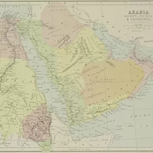
Premium Framed Print : Map of Egypt and Darfur 1900


![]()
Framed Photos from Fine Art Storehouse
Map of Egypt and Darfur 1900
Meyers hand-Atlas Leipzig und Wien Verlag des Bibliographischen Instituts 1900
Unleash your creativity and transform your space into a visual masterpiece!
THEPALMER
Media ID 18106889
© 2014 Roberto Adrian Photography
17"x15" (43x38cm) Premium Frame
FSC real wood frame with double mounted 10x8 print. Double mounted with white conservation mountboard. Frame moulding comprises stained composite natural wood veneers (Finger Jointed Pine) 39mm wide by 21mm thick. Archival quality Fujifilm CA photo paper mounted onto 1mm card. Overall outside dimensions are 17x15 inches (431x381mm). Rear features Framing tape to cover staples, 50mm Hanger plate, cork bumpers. Glazed with durable thick 2mm Acrylic to provide a virtually unbreakable glass-like finish. Acrylic Glass is far safer, more flexible and much lighter than typical mineral glass. Moreover, its higher translucency makes it a perfect carrier for photo prints. Acrylic allows a little more light to penetrate the surface than conventional glass and absorbs UV rays so that the image and the picture quality doesn't suffer under direct sunlight even after many years. Easily cleaned with a damp cloth. Please note that, to prevent the paper falling through the mount window and to prevent cropping of the original artwork, the visible print may be slightly smaller to allow the paper to be securely attached to the mount without any white edging showing and to match the aspect ratio of the original artwork.
FSC Real Wood Frame and Double Mounted with White Conservation Mountboard - Professionally Made and Ready to Hang
Estimated Image Size (if not cropped) is 19.2cm x 24.4cm (7.6" x 9.6")
Estimated Product Size is 38.1cm x 43.1cm (15" x 17")
These are individually made so all sizes are approximate
Artwork printed orientated as per the preview above, with portrait (vertical) orientation to match the source image.
FEATURES IN THESE COLLECTIONS
> Fine Art Storehouse
> Map
> Historical Maps
> Africa
> Egypt
> Related Images
EDITORS COMMENTS
This print titled "Map of Egypt and Darfur 1900" takes us on a visual journey back in time to the turn of the 20th century. The map, originally published in Meyers hand-Atlas Leipzig und Wien Verlag des Bibliographischen Instituts in 1900, offers a fascinating glimpse into the geopolitical landscape of Egypt and Darfur during that era. The intricate details depicted on this vintage map are truly remarkable. Every contour line, river, city, and border has been meticulously etched onto its surface by skilled cartographers of yesteryears. As we examine it closely, we can almost feel ourselves being transported to an era where exploration and discovery were at their peak. Egypt's iconic Nile River dominates the center stage as it winds its way through ancient cities such as Cairo and Luxor. Surrounding it are vast stretches of desert sands that seem to hold countless untold stories within their dunes. Towards the west lies Darfur, with its own unique topography waiting to be explored. "The Palmer" whose name is associated with this beautiful print from Fine Art Storehouse, has managed to capture not only historical accuracy but also a sense of nostalgia through his expert reproduction techniques. This photograph allows us to appreciate both the artistry involved in creating these maps and their significance as valuable historical artifacts. Whether you're a history enthusiast or simply captivated by the beauty of vintage cartography, this print serves as a stunning reminder of how our world has evolved
MADE IN THE UK
Safe Shipping with 30 Day Money Back Guarantee
FREE PERSONALISATION*
We are proud to offer a range of customisation features including Personalised Captions, Color Filters and Picture Zoom Tools
SECURE PAYMENTS
We happily accept a wide range of payment options so you can pay for the things you need in the way that is most convenient for you
* Options may vary by product and licensing agreement. Zoomed Pictures can be adjusted in the Basket.