Acrylic Blox > Africa > Egypt > Maps
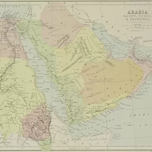
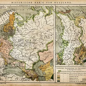
Acrylic Blox : Map of Egypt and Darfur 1900


![]()
Mounted Prints from Fine Art Storehouse
Map of Egypt and Darfur 1900
Meyers hand-Atlas Leipzig und Wien Verlag des Bibliographischen Instituts 1900
Unleash your creativity and transform your space into a visual masterpiece!
THEPALMER
Media ID 18106889
© 2014 Roberto Adrian Photography
8"x6" (20x15cm) Acrylic Blox
Your photographic print is held in place by magnets and a micro thin sheet of metal covering the back of a 20mm piece of clear acrylic. Your print is held in place with magnets so can easily be replaced if needed.
Streamlined, one sided modern and attractive table top print
Estimated Product Size is 15.2cm x 20.3cm (6" x 8")
These are individually made so all sizes are approximate
Artwork printed orientated as per the preview above, with portrait (vertical) orientation to match the source image.
FEATURES IN THESE COLLECTIONS
> Africa
> Egypt
> Related Images
> Fine Art Storehouse
> Map
> Historical Maps
EDITORS COMMENTS
This print titled "Map of Egypt and Darfur 1900" takes us on a visual journey back in time to the turn of the 20th century. The map, originally published in Meyers hand-Atlas Leipzig und Wien Verlag des Bibliographischen Instituts in 1900, offers a fascinating glimpse into the geopolitical landscape of Egypt and Darfur during that era. The intricate details depicted on this vintage map are truly remarkable. Every contour line, river, city, and border has been meticulously etched onto its surface by skilled cartographers of yesteryears. As we examine it closely, we can almost feel ourselves being transported to an era where exploration and discovery were at their peak. Egypt's iconic Nile River dominates the center stage as it winds its way through ancient cities such as Cairo and Luxor. Surrounding it are vast stretches of desert sands that seem to hold countless untold stories within their dunes. Towards the west lies Darfur, with its own unique topography waiting to be explored. "The Palmer" whose name is associated with this beautiful print from Fine Art Storehouse, has managed to capture not only historical accuracy but also a sense of nostalgia through his expert reproduction techniques. This photograph allows us to appreciate both the artistry involved in creating these maps and their significance as valuable historical artifacts. Whether you're a history enthusiast or simply captivated by the beauty of vintage cartography, this print serves as a stunning reminder of how our world has evolved
MADE IN THE UK
Safe Shipping with 30 Day Money Back Guarantee
FREE PERSONALISATION*
We are proud to offer a range of customisation features including Personalised Captions, Color Filters and Picture Zoom Tools
SECURE PAYMENTS
We happily accept a wide range of payment options so you can pay for the things you need in the way that is most convenient for you
* Options may vary by product and licensing agreement. Zoomed Pictures can be adjusted in the Basket.