Premium Framed Print > Animals > Mammals > Cricetidae > Golden Mouse
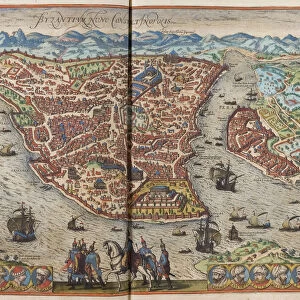
Premium Framed Print : Antique map of Constantinople, present day Istanbul


![]()
Framed Photos from Fine Art Storehouse
Antique map of Constantinople, present day Istanbul
Unleash your creativity and transform your space into a visual masterpiece!
Hemera Technologies
Media ID 13609419
© Getty Images
Bosphorus Byzantine Constantinople Direction Geography Golden Horn Istanbul Istanbul Legend Location Middle East Place Positioning Turkey Turkey Middle East Bosphorus Strait Byzantium Golden Horn Sea Of Marmara
17"x15" (43x38cm) Premium Frame
FSC real wood frame with double mounted 10x8 print. Double mounted with white conservation mountboard. Frame moulding comprises stained composite natural wood veneers (Finger Jointed Pine) 39mm wide by 21mm thick. Archival quality Fujifilm CA photo paper mounted onto 1mm card. Overall outside dimensions are 17x15 inches (431x381mm). Rear features Framing tape to cover staples, 50mm Hanger plate, cork bumpers. Glazed with durable thick 2mm Acrylic to provide a virtually unbreakable glass-like finish. Acrylic Glass is far safer, more flexible and much lighter than typical mineral glass. Moreover, its higher translucency makes it a perfect carrier for photo prints. Acrylic allows a little more light to penetrate the surface than conventional glass and absorbs UV rays so that the image and the picture quality doesn't suffer under direct sunlight even after many years. Easily cleaned with a damp cloth. Please note that, to prevent the paper falling through the mount window and to prevent cropping of the original artwork, the visible print may be slightly smaller to allow the paper to be securely attached to the mount without any white edging showing and to match the aspect ratio of the original artwork.
FSC Real Wood Frame and Double Mounted with White Conservation Mountboard - Professionally Made and Ready to Hang
Estimated Image Size (if not cropped) is 24.4cm x 20cm (9.6" x 7.9")
Estimated Product Size is 43.1cm x 38.1cm (17" x 15")
These are individually made so all sizes are approximate
Artwork printed orientated as per the preview above, with landscape (horizontal) orientation to match the source image.
FEATURES IN THESE COLLECTIONS
> Fine Art Storehouse
> Map
> Historical Maps
> Animals
> Mammals
> Cricetidae
> Golden Mouse
> Asia
> Related Images
> Asia
> Turkey
> Related Images
> Europe
> Related Images
> Maps and Charts
> Early Maps
> Maps and Charts
> Related Images
EDITORS COMMENTS
This print showcases an antique map of Constantinople, the enchanting city that is now known as Istanbul. With its rich history and cultural significance, this archival piece takes us back in time to explore the ancient wonders of Byzantium. The intricate engravings on this vintage map beautifully depict the geography and positioning of this iconic city, nestled between the Bosphorus Strait and the Sea of Marmara. As we delve into this historical artifact, our eyes are drawn to key landmarks such as the Golden Horn, a natural harbor that has witnessed countless maritime adventures throughout centuries. The detailed legend provides insight into various elements represented on the map, allowing us to navigate through Constantinople's streets and neighborhoods with ease. Transported by Hemera Technologies' skillful photography, we find ourselves immersed in a world where East meets West. This horizontal composition captures every detail in vibrant color, bringing life to each street corner and architectural marvels that have stood tall for generations. With no people present within its frame, this image invites us to reflect upon Constantinople's past glory while contemplating its enduring legacy today. It serves as a reminder of how history shapes our present reality and inspires curiosity about what lies beyond these ancient walls. Whether you're an avid cartography enthusiast or simply captivated by Istanbul's allure, this antique print offers a window into a bygone era - an exquisite addition to any art collection or space longing for timeless beauty.
MADE IN THE UK
Safe Shipping with 30 Day Money Back Guarantee
FREE PERSONALISATION*
We are proud to offer a range of customisation features including Personalised Captions, Color Filters and Picture Zoom Tools
SECURE PAYMENTS
We happily accept a wide range of payment options so you can pay for the things you need in the way that is most convenient for you
* Options may vary by product and licensing agreement. Zoomed Pictures can be adjusted in the Basket.