Premium Framed Print > Europe > Denmark > Maps
Premium Framed Print : Map of Denmark 1900


![]()
Framed Photos From Fine Art Storehouse
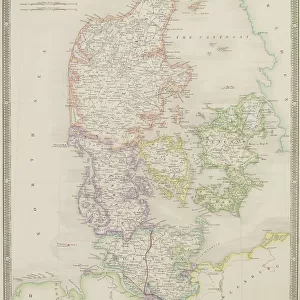
Map of Denmark 1900
Meyers hand-Atlas Leipzig und Wien Verlag des Bibliographischen Instituts 1900
Unleash your creativity and transform your space into a visual masterpiece!
THEPALMER
Media ID 18106907
© 2014 Roberto Adrian Photography
17"x15" (43x38cm) Premium Frame
FSC real wood frame with double mounted 10x8 print. Double mounted with white conservation mountboard. Frame moulding comprises stained composite natural wood veneers (Finger Jointed Pine) 39mm wide by 21mm thick. Archival quality Fujifilm CA photo paper mounted onto 1mm card. Overall outside dimensions are 17x15 inches (431x381mm). Rear features Framing tape to cover staples, 50mm Hanger plate, cork bumpers. Glazed with durable thick 2mm Acrylic to provide a virtually unbreakable glass-like finish. Acrylic Glass is far safer, more flexible and much lighter than typical mineral glass. Moreover, its higher translucency makes it a perfect carrier for photo prints. Acrylic allows a little more light to penetrate the surface than conventional glass and absorbs UV rays so that the image and the picture quality doesn't suffer under direct sunlight even after many years. Easily cleaned with a damp cloth. Please note that, to prevent the paper falling through the mount window and to prevent cropping of the original artwork, the visible print may be slightly smaller to allow the paper to be securely attached to the mount without any white edging showing and to match the aspect ratio of the original artwork.
FSC Real Wood Frame and Double Mounted with White Conservation Mountboard - Professionally Made and Ready to Hang
Estimated Image Size (if not cropped) is 20.2cm x 24.4cm (8" x 9.6")
Estimated Product Size is 38.1cm x 43.1cm (15" x 17")
These are individually made so all sizes are approximate
Artwork printed orientated as per the preview above, with portrait (vertical) orientation to match the source image.
FEATURES IN THESE COLLECTIONS
> Fine Art Storehouse
> Map
> Denmark Maps
> Fine Art Storehouse
> Map
> Historical Maps
> Europe
> Denmark
> Related Images
EDITORS COMMENTS
In this print titled "Map of Denmark 1900". THEPALMER takes us on a journey back in time to explore the intricate details of a bygone era. This vintage map, sourced from Meyers hand-Atlas Leipzig und Wien Verlag des Bibliographischen Instituts 1900, offers an intriguing glimpse into the geographical landscape and historical context of Denmark at the turn of the century. The artist's meticulous attention to detail is evident as we observe every delicate line and intricately drawn border that defines each region within this beautiful country. The faded hues and aged texture add a sense of nostalgia, inviting viewers to immerse themselves in the rich history embedded within these cartographic lines. As we study this mesmerizing piece, our eyes are drawn to key landmarks such as Copenhagen, Aarhus, Odense, and countless other cities that have witnessed centuries of Danish culture unfold. We can almost imagine ourselves tracing ancient trade routes or envisioning how life might have been for those who inhabited these lands long ago. "The Map of Denmark 1900" serves not only as a visual delight but also as a valuable educational tool for historians and enthusiasts alike. It reminds us of the importance of preserving our past while igniting curiosity about how societies evolve over time. THEPALMER's masterful capture allows us to appreciate both the artistry involved in creating maps during this period and their significance in understanding our world's ever-changing geography.
MADE IN THE UK
Safe Shipping with 30 Day Money Back Guarantee
FREE PERSONALISATION*
We are proud to offer a range of customisation features including Personalised Captions, Color Filters and Picture Zoom Tools
SECURE PAYMENTS
We happily accept a wide range of payment options so you can pay for the things you need in the way that is most convenient for you
* Options may vary by product and licensing agreement. Zoomed Pictures can be adjusted in the Basket.