Premium Framed Print > Fine Art Storehouse > Map
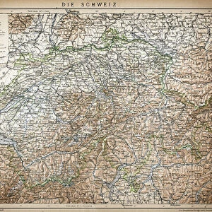
Premium Framed Print : Switzerland map 1875


![]()
Framed Photos from Fine Art Storehouse
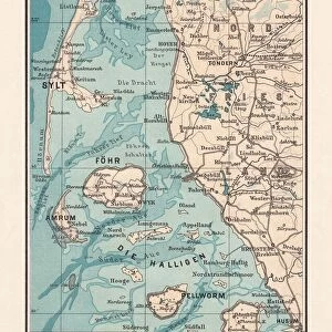
Switzerland map 1875
The Independent Course Comprehensive Geography by James Monteith, A.S. Barnes & Co, New York & Chicago 1875
Unleash your creativity and transform your space into a visual masterpiece!
THEPALMER
Media ID 13612215
© This content is subject to copyright
Globe Navigational Equipment Paper Switzerland Drawing Art Product
17"x15" (43x38cm) Premium Frame
FSC real wood frame with double mounted 10x8 print. Double mounted with white conservation mountboard. Frame moulding comprises stained composite natural wood veneers (Finger Jointed Pine) 39mm wide by 21mm thick. Archival quality Fujifilm CA photo paper mounted onto 1mm card. Overall outside dimensions are 17x15 inches (431x381mm). Rear features Framing tape to cover staples, 50mm Hanger plate, cork bumpers. Glazed with durable thick 2mm Acrylic to provide a virtually unbreakable glass-like finish. Acrylic Glass is far safer, more flexible and much lighter than typical mineral glass. Moreover, its higher translucency makes it a perfect carrier for photo prints. Acrylic allows a little more light to penetrate the surface than conventional glass and absorbs UV rays so that the image and the picture quality doesn't suffer under direct sunlight even after many years. Easily cleaned with a damp cloth. Please note that, to prevent the paper falling through the mount window and to prevent cropping of the original artwork, the visible print may be slightly smaller to allow the paper to be securely attached to the mount without any white edging showing and to match the aspect ratio of the original artwork.
FSC Real Wood Frame and Double Mounted with White Conservation Mountboard - Professionally Made and Ready to Hang
Estimated Image Size (if not cropped) is 24.4cm x 17cm (9.6" x 6.7")
Estimated Product Size is 43.1cm x 38.1cm (17" x 15")
These are individually made so all sizes are approximate
Artwork printed orientated as per the preview above, with landscape (horizontal) orientation to match the source image.
FEATURES IN THESE COLLECTIONS
> Fine Art Storehouse
> The Magical World of Illustration
> Palmer Illustrated Collection
> Fine Art Storehouse
> Map
> Historical Maps
EDITORS COMMENTS
This print showcases a piece of history frozen in time - the Switzerland map from 1875. Taken from "The Independent Course Comprehensive Geography" by James Monteith, this vintage artifact was published by A. S. Barnes & Co in New York and Chicago, making it a true testament to the rich cartographic heritage of the United States. The intricate details etched on paper through engraving techniques transport us back to an era when maps were meticulously crafted works of art. The beauty lies not only in its historical significance but also in its aesthetic appeal. The horizontal composition allows for a panoramic view of Switzerland's diverse topography, while the delicate lines and shading bring out every contour and feature with precision. This old-world charm is further enhanced by the antique quality of the image, evoking nostalgia for a time long gone. As we gaze upon this mesmerizing illustration, we are reminded of nature's grandeur that has remained unchanged over centuries. From majestic mountains to serene lakes and winding rivers, Switzerland's physical geography unfolds before our eyes like a masterpiece waiting to be explored. "The Independent Course Comprehensive Geography" map serves as both an educational tool and a window into another era. It invites us to appreciate the artistry behind cartography while igniting our curiosity about Switzerland's past and present landscapes. Thanks to THEPALMER's skillful capture, this remarkable piece can now be admired as an exquisite drawing art product that transcends time itself.
MADE IN THE UK
Safe Shipping with 30 Day Money Back Guarantee
FREE PERSONALISATION*
We are proud to offer a range of customisation features including Personalised Captions, Color Filters and Picture Zoom Tools
SECURE PAYMENTS
We happily accept a wide range of payment options so you can pay for the things you need in the way that is most convenient for you
* Options may vary by product and licensing agreement. Zoomed Pictures can be adjusted in the Basket.