Premium Framed Print > North America > Haiti > Maps
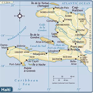
Premium Framed Print : The islands of the Greater Antilles and the Lesser Antilles in the Caribbean Sea (map


![]()
Framed Photos From Fine Art Finder
The islands of the Greater Antilles and the Lesser Antilles in the Caribbean Sea (map
LRI4648655 The islands of the Greater Antilles and the Lesser Antilles in the Caribbean Sea (map, 1500) by Unknown Artist, (16th century); Museo de America, Madrid, Spain; (add.info.: Geography map: representation of the islands of the Greater Antilles (Cuba, Hispaniola, Jamaica and Puerto Rico) and the Lesser Antilles in the Caribbean Sea - 1500 - Madrid, Museo di America); Luisa Ricciarini; out of copyright
Media ID 23715864
© Luisa Ricciarini / Bridgeman Images
Caribbean Central America Cuba Cuban Dominium Haiti Jamaica Jamaican Geographical Map
23"x19" (58x48cm) Premium Frame
FSC real wood frame with double mounted 16x12 print. Double mounted with white conservation mountboard. Frame moulding comprises stained composite natural wood veneers (Finger Jointed Pine) 39mm wide by 21mm thick. Archival quality Fujifilm CA photo paper mounted onto 1mm card. Overall outside dimensions are 23x19 inches (584x482mm). Rear features Framing tape to cover staples, 50mm Hanger plate, cork bumpers. Glazed with durable thick 2mm Acrylic to provide a virtually unbreakable glass-like finish. Acrylic Glass is far safer, more flexible and much lighter than typical mineral glass. Moreover, its higher translucency makes it a perfect carrier for photo prints. Acrylic allows a little more light to penetrate the surface than conventional glass and absorbs UV rays so that the image and the picture quality doesn't suffer under direct sunlight even after many years. Easily cleaned with a damp cloth. Please note that, to prevent the paper falling through the mount window and to prevent cropping of the original artwork, the visible print may be slightly smaller to allow the paper to be securely attached to the mount without any white edging showing and to match the aspect ratio of the original artwork.
FSC Real Wood Frame and Double Mounted with White Conservation Mountboard - Professionally Made and Ready to Hang
Estimated Image Size (if not cropped) is 39.6cm x 21.5cm (15.6" x 8.5")
Estimated Product Size is 58.4cm x 48.2cm (23" x 19")
These are individually made so all sizes are approximate
Artwork printed orientated as per the preview above, with landscape (horizontal) orientation to match the source image.
FEATURES IN THESE COLLECTIONS
> Fine Art Finder
> Artists
> Unknown Artist
> Arts
> Artists
> Related Images
> Maps and Charts
> Related Images
> Maps and Charts
> Spain
> North America
> Cuba
> Maps
> North America
> Cuba
> Related Images
> North America
> Haiti
> Maps
EDITORS COMMENTS
This print showcases a historical map titled "The islands of the Greater Antilles and the Lesser Antilles in the Caribbean Sea" created by an unknown artist during the 16th century. Housed at Museo de America in Madrid, Spain, this masterpiece offers a fascinating glimpse into the geography of the Caribbean region during that era. The map vividly illustrates the islands comprising both the Greater Antilles (Cuba, Hispaniola, Jamaica, and Puerto Rico) and Lesser Antilles. It serves as a testament to the rich history and cultural significance of these lands. The intricate details on this ancient cartographic representation highlight its importance as a navigational tool for explorers and traders who ventured into these waters. Luisa Ricciarini's expert photography captures every nuance of this remarkable artwork while preserving its historical value. Through her lens, viewers can appreciate not only its aesthetic beauty but also gain insight into how our understanding of geography has evolved over time. As we gaze upon this image, we are transported back to a time when these islands were still unexplored territories waiting to be discovered. It reminds us of their strategic location within Central America and their role in shaping trade routes between Europe and the Americas. This print is not just an artistic treasure; it is also an invaluable educational resource that allows us to delve deeper into our shared past.
MADE IN THE UK
Safe Shipping with 30 Day Money Back Guarantee
FREE PERSONALISATION*
We are proud to offer a range of customisation features including Personalised Captions, Color Filters and Picture Zoom Tools
SECURE PAYMENTS
We happily accept a wide range of payment options so you can pay for the things you need in the way that is most convenient for you
* Options may vary by product and licensing agreement. Zoomed Pictures can be adjusted in the Basket.