Premium Framed Print > Asia > Iran > Maps
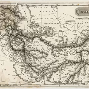
Premium Framed Print : Map of the empire of Darius (tribute paying countries) at its greatest extent, 1936
 at its greatest extent, 1936")
 at its greatest extent, 1936")


![]()
Framed Photos From Fine Art Finder
Map of the empire of Darius (tribute paying countries) at its greatest extent, 1936
7125141 Map of the empire of Darius (tribute paying countries) at its greatest extent, 1936; (add.info.: Map of the empire of Darius (tribute paying countries) at its greatest extent. Darius I, c. 550 - 486 BC, aka Darius the Great. Third Iranian King of Kings of the Achaemenid Empire. From A Short History of the World, published c.1936); Photo © Ken Welsh. All rights reserved 2024
Media ID 38432930
© © Ken Welsh. All rights reserved 2024 / Bridgeman Images
5 5th V Vth Century 5th 5th 5th V Vth Th Century 5th Century 6 6th Vi Vith Century 6th 6th 6th Vi Vith Vith Century 6th Century Achaemenian Achaemenian Empire Achaemenian Period Achaemenid Empire Achaemenids Ageing C5th C6th Darius 1 Darius I Darius The Great Imperials Iran Iranian Iranians Persia Persians Run Down Sixth Century Ad Vi Century Vith Century Vth Century Geographer
17"x15" (43x38cm) Premium Frame
FSC real wood frame with double mounted 10x8 print. Double mounted with white conservation mountboard. Frame moulding comprises stained composite natural wood veneers (Finger Jointed Pine) 39mm wide by 21mm thick. Archival quality Fujifilm CA photo paper mounted onto 1mm card. Overall outside dimensions are 17x15 inches (431x381mm). Rear features Framing tape to cover staples, 50mm Hanger plate, cork bumpers. Glazed with durable thick 2mm Acrylic to provide a virtually unbreakable glass-like finish. Acrylic Glass is far safer, more flexible and much lighter than typical mineral glass. Moreover, its higher translucency makes it a perfect carrier for photo prints. Acrylic allows a little more light to penetrate the surface than conventional glass and absorbs UV rays so that the image and the picture quality doesn't suffer under direct sunlight even after many years. Easily cleaned with a damp cloth. Please note that, to prevent the paper falling through the mount window and to prevent cropping of the original artwork, the visible print may be slightly smaller to allow the paper to be securely attached to the mount without any white edging showing and to match the aspect ratio of the original artwork.
FSC Real Wood Frame and Double Mounted with White Conservation Mountboard - Professionally Made and Ready to Hang
Estimated Image Size (if not cropped) is 24.4cm x 17.9cm (9.6" x 7")
Estimated Product Size is 43.1cm x 38.1cm (17" x 15")
These are individually made so all sizes are approximate
Artwork printed orientated as per the preview above, with landscape (horizontal) orientation to match the source image.
FEATURES IN THESE COLLECTIONS
> Fine Art Finder
> Artists
> Duncan McGregor Whyte
> Asia
> Iran
> Related Images
> Maps and Charts
> Early Maps
> Maps and Charts
> Related Images
> Maps and Charts
> World
EDITORS COMMENTS
This stunning print captures the Map of the empire of Darius at its greatest extent in 1936. The intricate details and aged appearance of this historical cartography piece transport us back to a time when the Achaemenid Empire was at its peak under the rule of Darius I, also known as Darius the Great.
Darius I, who reigned from approximately 550-486 BC, was the third Iranian King of Kings and played a significant role in expanding and solidifying the empire's power. This map showcases all the tribute paying countries that were under his control during this period.
The engraving work on this map is truly remarkable, highlighting not only the geographical boundaries but also providing insight into the imperial reach and influence of Darius' reign. From Iran to other parts of Asia and Africa, this map symbolizes an era of great conquests and advancements in history.
As we gaze upon this aged yet captivating piece, we are reminded of the rich heritage and legacy left behind by Darius I and his empire. It serves as a reminder of how far-reaching empires once were, shaping cultures and societies for generations to come.
MADE IN THE UK
Safe Shipping with 30 Day Money Back Guarantee
FREE PERSONALISATION*
We are proud to offer a range of customisation features including Personalised Captions, Color Filters and Picture Zoom Tools
SECURE PAYMENTS
We happily accept a wide range of payment options so you can pay for the things you need in the way that is most convenient for you
* Options may vary by product and licensing agreement. Zoomed Pictures can be adjusted in the Basket.