Poster Print > Maps and Charts > Africa
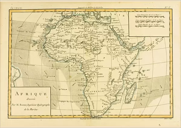
Poster Print : Map of Africa, circa. 1760. From Atlas de Toutes Les Parties Connues du Globe Terrestre


![]()
Poster Prints from Universal Images Group (UIG)
Map of Africa, circa. 1760. From Atlas de Toutes Les Parties Connues du Globe Terrestre
Map of Africa, circa.1760. From Atlas de Toutes Les Parties Connues du Globe Terrestre by Cartographer Rigobert Bonne. Published Geneva circa. 1760
Universal Images Group (UIG) manages distribution for many leading specialist agencies worldwide
Media ID 20165287
© Universal Images Group
Africa Color Colour Mapmaking Plate Welsh
A2 (59.4 x 42cm) Poster Print
Step back in time with our vintage Map of Africa print from Media Storehouse. This beautiful poster, derived from the 1760 edition of "Atlas de Toutes Les Parties Connues du Globe Terrestre" by renowned cartographer Rigobert Bonne, offers a fascinating glimpse into the historical understanding of the African continent during that era. With intricate detail and authentic antique charm, this map print is a captivating addition to any home or office decor. Transport yourself back in time and add a touch of history to your space with our Map of Africa print from Media Storehouse.
A2 Poster (59.4 x 42cm, 23.4" x 16.5" inches) printed on 170gsm Satin Poster Paper. Securely packaged, rolled and inserted into a strong mailing tube and shipped tracked. Poster Prints are of comparable archival quality to our Photographic prints, they are simply printed on thinner Poster Paper. Whilst we only use Photographic Prints in our frames, you can frame Poster Prints if they are carefully supported to prevent sagging over time.
Poster prints are budget friendly enlarged prints in standard poster paper sizes (A0, A1, A2, A3 etc). Whilst poster paper is sometimes thinner and less durable than our other paper types, they are still ok for framing and should last many years. Our Archival Quality Photo Prints and Fine Art Paper Prints are printed on higher quality paper and the choice of which largely depends on your budget.
Estimated Image Size (if not cropped) is 59.4cm x 40.8cm (23.4" x 16.1")
Estimated Product Size is 59.4cm x 42cm (23.4" x 16.5")
These are individually made so all sizes are approximate
Artwork printed orientated as per the preview above, with landscape (horizontal) orientation to match the source image.
FEATURES IN THESE COLLECTIONS
> Maps and Charts
> Related Images
> Universal Images Group (UIG)
> History
> Historical Maps
EDITORS COMMENTS
This stunning print showcases a rare and exquisite "Map of Africa" from the year 1760. Taken from the renowned Atlas de Toutes Les Parties Connues du Globe Terrestre by Cartographer Rigobert Bonne, this horizontal, color illustration offers a fascinating glimpse into the geography of Africa during that era. The intricate details and vibrant colors of this map bring to life the diverse landscapes and rich history of the African continent. From its northern deserts to its lush rainforests in the south, every corner is meticulously depicted with precision and artistry. Engraved on a plate by Welsh cartographer Ken, this masterpiece captures not only geographical features but also historical landmarks and cultural symbols unique to each region. It serves as a testament to the skillful craftsmanship involved in mapmaking during that time period. Published in Geneva around 1760, this Map of Africa holds immense historical value as it provides valuable insights into how our understanding of geography has evolved over centuries. It reminds us of the explorers who ventured into unknown territories, paving the way for future discoveries. With its timeless beauty and educational significance, this print is an ideal addition for any history enthusiast or lover of cartography. Whether displayed in homes or educational institutions, it invites viewers to embark on a visual journey through time while appreciating Africa's vastness and complexity.
MADE IN THE UK
Safe Shipping with 30 Day Money Back Guarantee
FREE PERSONALISATION*
We are proud to offer a range of customisation features including Personalised Captions, Color Filters and Picture Zoom Tools
SECURE PAYMENTS
We happily accept a wide range of payment options so you can pay for the things you need in the way that is most convenient for you
* Options may vary by product and licensing agreement. Zoomed Pictures can be adjusted in the Basket.