Poster Print > Europe > United Kingdom > England > London > Museums > Science Museum
Poster Print : William Smiths Geological Map


![]()
Poster Prints from Science Photo Library
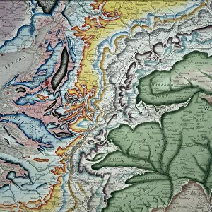
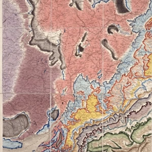
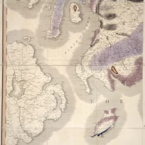
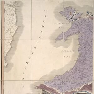
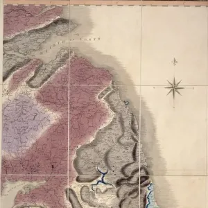
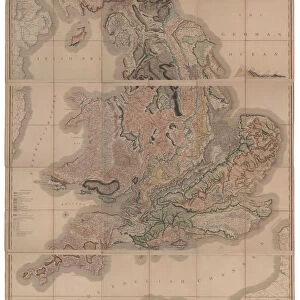
William Smiths Geological Map
William Smiths Geological Map. Fig. 9 from Delineation of Strata of England and Wales (1815) by William Smith
Science Photo Library features Science and Medical images including photos and illustrations
Media ID 9206571
© NATURAL HISTORY MUSEUM, LONDON/SCIENCE PHOTO LIBRARY
Geological Great Britain Rock Smith Strata Stratification Type Wales William Smith 1769 1839 Geological Map
A2 (59.4 x 42cm) Poster Print
Discover the rich history of geology with our stunning poster prints from the Media Storehouse collection. Featuring the iconic "William Smith's Geological Map" from the Natural History Museum, London/Science Photo Library, this poster is a must-have for any home or office. Originally published in 1815 by William Smith, this map marked a significant milestone in the field of geology by providing the first comprehensive overview of the stratigraphic succession of rocks in England and Wales. Bring a piece of scientific history into your space and ignite conversations with this beautifully printed and framed poster.
A2 Poster (59.4 x 42cm, 23.4" x 16.5" inches) printed on 170gsm Satin Poster Paper. Securely packaged, rolled and inserted into a strong mailing tube and shipped tracked. Poster Prints are of comparable archival quality to our Photographic prints, they are simply printed on thinner Poster Paper. Whilst we only use Photographic Prints in our frames, you can frame Poster Prints if they are carefully supported to prevent sagging over time.
Poster prints are budget friendly enlarged prints in standard poster paper sizes (A0, A1, A2, A3 etc). Whilst poster paper is sometimes thinner and less durable than our other paper types, they are still ok for framing and should last many years. Our Archival Quality Photo Prints and Fine Art Paper Prints are printed on higher quality paper and the choice of which largely depends on your budget.
Estimated Image Size (if not cropped) is 34.7cm x 59.4cm (13.7" x 23.4")
Estimated Product Size is 42cm x 59.4cm (16.5" x 23.4")
These are individually made so all sizes are approximate
Artwork printed orientated as per the preview above, with portrait (vertical) orientation to match the source image.
FEATURES IN THESE COLLECTIONS
> Europe
> United Kingdom
> England
> London
> Museums
> British Library
> Europe
> United Kingdom
> England
> London
> Museums
> British Museum
> Europe
> United Kingdom
> England
> London
> Museums
> Natural History Museum
> Europe
> United Kingdom
> England
> London
> Museums
> Science Museum
> Europe
> United Kingdom
> England
> London
> Sights
> British Museum
> Europe
> United Kingdom
> England
> Maps
> Europe
> United Kingdom
> Maps
> Europe
> United Kingdom
> Related Images
> Europe
> United Kingdom
> Wales
> Maps
> Europe
> United Kingdom
> Wales
> Posters
EDITORS COMMENTS
This print showcases the iconic "William Smiths Geological Map" created by William Smith in 1815. The map, depicted in Figure 9 of his renowned publication "Delineation of Strata of England and Wales" is a groundbreaking representation of the geological formations found throughout Great Britain. The image captures the intricate details and vibrant colors present on this historical map, which has become an invaluable resource for understanding the geology of not only England and Wales but also Europe as a whole. William Smith's meticulous work revolutionized the field of geology by introducing stratification principles that laid the foundation for modern geological mapping. Displayed proudly at the Natural History Museum in London, this print serves as a testament to both Smith's scientific brilliance and artistic skill. Each type of rock and stratum is meticulously illustrated, allowing viewers to appreciate the complexity and diversity within Earth's layers. As we gaze upon this remarkable piece, we are reminded of how one individual's dedication can shape our understanding of our planet's history. This photograph invites us to explore not only the geological wonders captured on this map but also to reflect on how scientific discoveries continue to transform our knowledge about Earth's past.
MADE IN THE UK
Safe Shipping with 30 Day Money Back Guarantee
FREE PERSONALISATION*
We are proud to offer a range of customisation features including Personalised Captions, Color Filters and Picture Zoom Tools
SECURE PAYMENTS
We happily accept a wide range of payment options so you can pay for the things you need in the way that is most convenient for you
* Options may vary by product and licensing agreement. Zoomed Pictures can be adjusted in the Basket.