Poster Print > Arts > Artists > T > Charles Towne
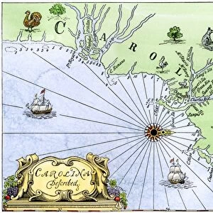
Poster Print : Map of colonial Charleston, South Carolina, 1600s


![]()
Poster Prints from North Wind
Map of colonial Charleston, South Carolina, 1600s
Colonial map of the Ashley and Cooper rivers, site of Charleston, South Carolina, 1600s.
Hand-colored 19th-century woodcut reproduction of a document
North Wind Picture Archives brings history to life with stock images and hand-colored illustrations
Media ID 5882523
© North Wind Picture Archives
1600s 17th Century Charleston City Colonial Colony English English Colony Harbor Port Sea Port Settlement South South Carolina Southern Town Ashley River Charles Towne Cooper River
A2 (59.4 x 42cm) Poster Print
Step back in time with our exquisite Map of Colonial Charleston, South Carolina, 1600s, from the Media Storehouse collection. This stunning reproduction, sourced from North Wind Picture Archives, showcases a hand-colored 19th-century woodcut depiction of a document. Explore the Ashley and Cooper rivers, and discover the early settlements around the site of Charleston, South Carolina, in this intricately detailed and historically significant poster print. Bring history to life in your home or office, and transport yourself to a bygone era with this captivating piece of wall art.
A2 Poster (59.4 x 42cm, 23.4" x 16.5" inches) printed on 170gsm Satin Poster Paper. Securely packaged, rolled and inserted into a strong mailing tube and shipped tracked. Poster Prints are of comparable archival quality to our Photographic prints, they are simply printed on thinner Poster Paper. Whilst we only use Photographic Prints in our frames, you can frame Poster Prints if they are carefully supported to prevent sagging over time.
Poster prints are budget friendly enlarged prints in standard poster paper sizes (A0, A1, A2, A3 etc). Whilst poster paper is sometimes thinner and less durable than our other paper types, they are still ok for framing and should last many years. Our Archival Quality Photo Prints and Fine Art Paper Prints are printed on higher quality paper and the choice of which largely depends on your budget.
Estimated Image Size (if not cropped) is 51.9cm x 42cm (20.4" x 16.5")
Estimated Product Size is 59.4cm x 42cm (23.4" x 16.5")
These are individually made so all sizes are approximate
Artwork printed orientated as per the preview above, with landscape (horizontal) orientation to match the source image.
FEATURES IN THESE COLLECTIONS
> North Wind Picture Archives
> Maps
> Arts
> Artists
> T
> Charles Towne
> Arts
> Landscape paintings
> Waterfall and river artworks
> River artworks
> Historic
> Colonial America illustrations
> Colonial America
> Historic
> Colonial America illustrations
> Historic
> Colonial history
> Colonial art and artists
> North America
> Related Images
> North America
> United States of America
> South Carolina
> Charleston
> South America
> Related Images
EDITORS COMMENTS
This print takes us back in time to the 1600s, offering a glimpse into the early days of colonial Charleston, South Carolina. The map showcases the intricate details of the Ashley and Cooper rivers, which served as the foundation for this historic city. Hand-colored with precision and care, this 19th-century woodcut reproduction brings to life an important document from our American heritage. As we explore this vintage illustration, we are transported to a bygone era filled with Southern charm and tradition. This map tells the story of a bustling settlement that would eventually become one of America's most significant sea ports. Its harbor played a pivotal role in shaping English history on North American soil. The artistry captured within these lines allows us to imagine what life was like during those early years when Charles Towne (as it was known then) began its journey towards becoming Charleston. It serves as a reminder of how far our great nation has come since those humble beginnings. With its rich historical significance and attention to detail, this colonial map is not just an artifact but also a window into our past. It invites us to appreciate the beauty and complexity of Charleston's development as an English colony while acknowledging its place within United States history.
MADE IN THE UK
Safe Shipping with 30 Day Money Back Guarantee
FREE PERSONALISATION*
We are proud to offer a range of customisation features including Personalised Captions, Color Filters and Picture Zoom Tools
SECURE PAYMENTS
We happily accept a wide range of payment options so you can pay for the things you need in the way that is most convenient for you
* Options may vary by product and licensing agreement. Zoomed Pictures can be adjusted in the Basket.