Glass Place Mat > Arts > Artists > T > Charles Towne
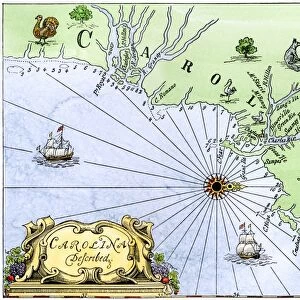
Glass Place Mat : Map of colonial Charleston, South Carolina, 1600s


![]()
Home Decor from North Wind
Map of colonial Charleston, South Carolina, 1600s
Colonial map of the Ashley and Cooper rivers, site of Charleston, South Carolina, 1600s.
Hand-colored 19th-century woodcut reproduction of a document
North Wind Picture Archives brings history to life with stock images and hand-colored illustrations
Media ID 5882523
© North Wind Picture Archives
1600s 17th Century Charleston City Colonial Colony English English Colony Harbor Port Sea Port Settlement South South Carolina Southern Town Ashley River Charles Towne Cooper River
Glass Place Mat (Set of 4)
Set of 4 Glass Place Mats. Stylish and elegant polished safety glass, toughened and heat resistant (275x225mm, 7mm thick). Matching Coasters also available.
Set of 4 Glass Place Mats. Elegant polished safety glass and heat resistant. Matching Coasters may also be available
Estimated Image Size (if not cropped) is 25.4cm x 20.5cm (10" x 8.1")
Estimated Product Size is 27.5cm x 22.5cm (10.8" x 8.9")
These are individually made so all sizes are approximate
FEATURES IN THESE COLLECTIONS
> Arts
> Artists
> T
> Charles Towne
> Arts
> Landscape paintings
> Waterfall and river artworks
> River artworks
> Historic
> Colonial America illustrations
> Colonial America
> Historic
> Colonial America illustrations
> Historic
> Colonial history
> Colonial art and artists
> North America
> Related Images
> North America
> United States of America
> South Carolina
> Charleston
> South America
> Related Images
> North Wind Picture Archives
> Maps
EDITORS COMMENTS
This print takes us back in time to the 1600s, offering a glimpse into the early days of colonial Charleston, South Carolina. The map showcases the intricate details of the Ashley and Cooper rivers, which served as the foundation for this historic city. Hand-colored with precision and care, this 19th-century woodcut reproduction brings to life an important document from our American heritage. As we explore this vintage illustration, we are transported to a bygone era filled with Southern charm and tradition. This map tells the story of a bustling settlement that would eventually become one of America's most significant sea ports. Its harbor played a pivotal role in shaping English history on North American soil. The artistry captured within these lines allows us to imagine what life was like during those early years when Charles Towne (as it was known then) began its journey towards becoming Charleston. It serves as a reminder of how far our great nation has come since those humble beginnings. With its rich historical significance and attention to detail, this colonial map is not just an artifact but also a window into our past. It invites us to appreciate the beauty and complexity of Charleston's development as an English colony while acknowledging its place within United States history.
MADE IN THE UK
Safe Shipping with 30 Day Money Back Guarantee
FREE PERSONALISATION*
We are proud to offer a range of customisation features including Personalised Captions, Color Filters and Picture Zoom Tools
SECURE PAYMENTS
We happily accept a wide range of payment options so you can pay for the things you need in the way that is most convenient for you
* Options may vary by product and licensing agreement. Zoomed Pictures can be adjusted in the Basket.