Poster Print > Europe > France > Maps
Poster Print : Map / Europe / France C1000


![]()
Poster Prints from Mary Evans Picture Library
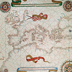
Map / Europe / France C1000
France in feudal times, with the country allotted to various nobles who bore more or less allegiance to the king, whose acquisitions are shown in map lower left
Mary Evans Picture Library makes available wonderful images created for people to enjoy over the centuries
Media ID 594579
© Mary Evans Picture Library 2015 - https://copyrighthub.org/s0/hub1/creation/maryevans/MaryEvansPictureID/10046920
1000 1500 Allegiance Allotted Bore Feudal Lower Maps Nobles Shown Times
A2 (59.4 x 42cm) Poster Print
Discover the rich history of feudal France with our captivating Map / Europe / France C1000 poster print from Media Storehouse, in partnership with Mary Evans Prints Online. This intricately detailed map transports you back in time, illustrating the country during the era of noble alliances and the king's acquisitions. Witness the intriguing political landscape of medieval France, as various territories are depicted with their distinctive borders and regional distinctions. Bring history to life in your home or office with this stunning and authentic poster print.
A2 Poster (59.4 x 42cm, 23.4" x 16.5" inches) printed on 170gsm Satin Poster Paper. Securely packaged, rolled and inserted into a strong mailing tube and shipped tracked. Poster Prints are of comparable archival quality to our Photographic prints, they are simply printed on thinner Poster Paper. Whilst we only use Photographic Prints in our frames, you can frame Poster Prints if they are carefully supported to prevent sagging over time.
Poster prints are budget friendly enlarged prints in standard poster paper sizes (A0, A1, A2, A3 etc). Whilst poster paper is sometimes thinner and less durable than our other paper types, they are still ok for framing and should last many years. Our Archival Quality Photo Prints and Fine Art Paper Prints are printed on higher quality paper and the choice of which largely depends on your budget.
Estimated Image Size (if not cropped) is 55.4cm x 42cm (21.8" x 16.5")
Estimated Product Size is 59.4cm x 42cm (23.4" x 16.5")
These are individually made so all sizes are approximate
Artwork printed orientated as per the preview above, with landscape (horizontal) orientation to match the source image.
FEATURES IN THESE COLLECTIONS
> Europe
> Related Images
> Maps and Charts
> Early Maps
> Maps and Charts
> Related Images
EDITORS COMMENTS
Step back in time with this map print of Feudal France in the year 1000, as depicted in the historical map "France C1000" from Mary Evans Prints Online. This map offers a fascinating glimpse into the complex political landscape of medieval France, where the country was allotted to various nobles who bore more or less allegiance to the king. At the lower left corner of the map, the acquisitions of the king are shown, providing a clear illustration of the monarch's territorial holdings during this period. The intricate details of the map reveal the vast expanse of lands controlled by these noble families, each with their own distinct territories and domains. As you explore this historical map, you'll notice the intricate borders that mark the territories of the various feudal lords, each with their unique symbols and insignia. The map also highlights the major cities and rivers of the time, providing context to the political and geographical landscape of medieval France. This map is a testament to the rich history of France during the feudal period, a time when the country was a patchwork of territories ruled by powerful nobles, each with their own allegiances and loyalties. The intricate details of this map offer a unique perspective into this complex and fascinating era, making it an essential addition to any history or map enthusiast's collection. The "France C1000" map is not only a beautiful work of art, but also an invaluable historical resource, providing insights into the political and geographical landscape of medieval France during a time of great change and transformation. Whether you're a history buff, a map collector, or simply someone with an interest in the Middle Ages, this map is sure to captivate and inspire you.
MADE IN THE UK
Safe Shipping with 30 Day Money Back Guarantee
FREE PERSONALISATION*
We are proud to offer a range of customisation features including Personalised Captions, Color Filters and Picture Zoom Tools
SECURE PAYMENTS
We happily accept a wide range of payment options so you can pay for the things you need in the way that is most convenient for you
* Options may vary by product and licensing agreement. Zoomed Pictures can be adjusted in the Basket.