Fine Art Print > Europe > France > Maps
Fine Art Print : Map / Europe / France C1000


![]()
Fine Art Prints from Mary Evans Picture Library
Map / Europe / France C1000
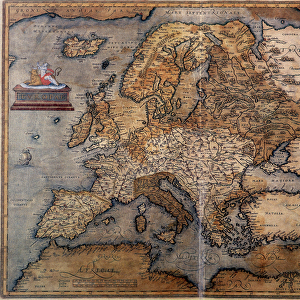
France in feudal times, with the country allotted to various nobles who bore more or less allegiance to the king, whose acquisitions are shown in map lower left
Mary Evans Picture Library makes available wonderful images created for people to enjoy over the centuries
Media ID 594579
© Mary Evans Picture Library 2015 - https://copyrighthub.org/s0/hub1/creation/maryevans/MaryEvansPictureID/10046920
1000 1500 Allegiance Allotted Bore Feudal Lower Maps Nobles Shown Times
A2 (42x59cm) Fine Art Print
Step back in time with our exquisite Fine Art Print from Media Storehouse, featuring the captivating map of Europe and France during the feudal era. This intricately detailed map from Mary Evans Prints Online transports you to an age of nobility and allegiance, where the territory of France is allotted to various lords and vassals, as depicted in the lower left corner. Add an air of sophistication and history to your space with this stunning, museum-quality print. Perfect for decorating your home or office, this Fine Art Print is a must-have for history enthusiasts and art collectors alike.
Our Fine Art Prints are printed on 100% acid free, PH neutral paper with archival properties. This printing method is used by museums and art collections to exhibit photographs and art reproductions. Hahnemühle certified studio for digital fine art printing. Printed on 308gsm Photo Rag Paper.
Our fine art prints are high-quality prints made using a paper called Photo Rag. This 100% cotton rag fibre paper is known for its exceptional image sharpness, rich colors, and high level of detail, making it a popular choice for professional photographers and artists. Photo rag paper is our clear recommendation for a fine art paper print. If you can afford to spend more on a higher quality paper, then Photo Rag is our clear recommendation for a fine art paper print.
Estimated Image Size (if not cropped) is 55.4cm x 42cm (21.8" x 16.5")
Estimated Product Size is 59.4cm x 42cm (23.4" x 16.5")
These are individually made so all sizes are approximate
Artwork printed orientated as per the preview above, with landscape (horizontal) orientation to match the source image.
FEATURES IN THESE COLLECTIONS
> Europe
> Related Images
> Maps and Charts
> Early Maps
> Maps and Charts
> Related Images
EDITORS COMMENTS
Step back in time with this map print of Feudal France in the year 1000, as depicted in the historical map "France C1000" from Mary Evans Prints Online. This map offers a fascinating glimpse into the complex political landscape of medieval France, where the country was allotted to various nobles who bore more or less allegiance to the king. At the lower left corner of the map, the acquisitions of the king are shown, providing a clear illustration of the monarch's territorial holdings during this period. The intricate details of the map reveal the vast expanse of lands controlled by these noble families, each with their own distinct territories and domains. As you explore this historical map, you'll notice the intricate borders that mark the territories of the various feudal lords, each with their unique symbols and insignia. The map also highlights the major cities and rivers of the time, providing context to the political and geographical landscape of medieval France. This map is a testament to the rich history of France during the feudal period, a time when the country was a patchwork of territories ruled by powerful nobles, each with their own allegiances and loyalties. The intricate details of this map offer a unique perspective into this complex and fascinating era, making it an essential addition to any history or map enthusiast's collection. The "France C1000" map is not only a beautiful work of art, but also an invaluable historical resource, providing insights into the political and geographical landscape of medieval France during a time of great change and transformation. Whether you're a history buff, a map collector, or simply someone with an interest in the Middle Ages, this map is sure to captivate and inspire you.
MADE IN THE UK
Safe Shipping with 30 Day Money Back Guarantee
FREE PERSONALISATION*
We are proud to offer a range of customisation features including Personalised Captions, Color Filters and Picture Zoom Tools
SECURE PAYMENTS
We happily accept a wide range of payment options so you can pay for the things you need in the way that is most convenient for you
* Options may vary by product and licensing agreement. Zoomed Pictures can be adjusted in the Basket.