Poster Print > North America > Canada > Maps
Poster Print : Hudsons Bay Map


![]()
Poster Prints from Mary Evans Picture Library
Hudsons Bay Map
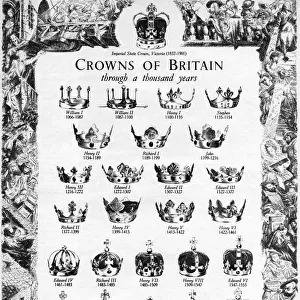
HUDSONs BAY, at the time of the Seven Years War, showing French and English forts including Fort York, the principal settlement of the Hudsons Bay Company
Mary Evans Picture Library makes available wonderful images created for people to enjoy over the centuries
Media ID 611103
© Mary Evans Picture Library 2015 - https://copyrighthub.org/s0/hub1/creation/maryevans/MaryEvansPictureID/10100649
1757 Fort Forts Hudsons Including Maps Principal Settlement Years
A2 (59.4 x 42cm) Poster Print
Discover the rich history of the Hudson Bay Company with our stunning poster prints from Media Storehouse, featuring the captivating "Hudsons Bay Map" by Mary Evans Picture Library. This intricately detailed map, dating back to the Seven Years War, showcases the strategic locations of key French and English forts, including Fort York, the principal settlement of the Hudsons Bay Company. Bring history to life in your home or office with this beautiful and informative piece, perfect for history enthusiasts, educators, or anyone interested in the fascinating story of the Hudson Bay Company's past. Order your Hudsons Bay Map poster print today and transport yourself back in time.
A2 Poster (59.4 x 42cm, 23.4" x 16.5" inches) printed on 170gsm Satin Poster Paper. Securely packaged, rolled and inserted into a strong mailing tube and shipped tracked. Poster Prints are of comparable archival quality to our Photographic prints, they are simply printed on thinner Poster Paper. Whilst we only use Photographic Prints in our frames, you can frame Poster Prints if they are carefully supported to prevent sagging over time.
Poster prints are budget friendly enlarged prints in standard poster paper sizes (A0, A1, A2, A3 etc). Whilst poster paper is sometimes thinner and less durable than our other paper types, they are still ok for framing and should last many years. Our Archival Quality Photo Prints and Fine Art Paper Prints are printed on higher quality paper and the choice of which largely depends on your budget.
Estimated Product Size is 59.4cm x 42cm (23.4" x 16.5")
These are individually made so all sizes are approximate
Artwork printed orientated as per the preview above, with landscape (horizontal) orientation to match the source image.
FEATURES IN THESE COLLECTIONS
> Maps and Charts
> Early Maps
> Maps and Charts
> Related Images
> North America
> Canada
> Maps
> North America
> Canada
> Related Images
EDITORS COMMENTS
This intricately detailed map, dated circa 1757, offers a captivating glimpse into the geopolitical landscape of North America during the Seven Years War. The focus of the map is the expansive Hudson Bay, a body of water that was of great strategic importance to both the French and English during this period. At the heart of the map, the principal English settlement of Fort York is depicted, marking the center of the Hudsons Bay Company's influence. Fort York, established in 1682, served as a vital trading post and military outpost for the English. The fort's strategic position at the mouth of the Niagara River provided control over the access to the Great Lakes and the rich resources they offered. Surrounding Fort York, several other English forts are shown, including those at Moose Factory, Albany, and James Bay. These forts were crucial to the English defense against French encroachment in the region. On the opposite side of the map, the French forts of New France are depicted. Notable among these is Fort Frontenac, located at the confluence of the St. Lawrence and Cataraqui Rivers. This fort was a significant stronghold for the French, providing access to the Great Lakes and control over the fur trade in the region. The map also highlights several rivers and waterways, including the Niagara, St. Lawrence, and Ottawa Rivers. These waterways were essential for transportation and communication between the various forts and settlements. This map offers a fascinating look into the complex political and military landscape of North America during the Seven Years War. The depiction of the forts and settlements along the Hudson Bay provides insight into the strategic importance of this region and the efforts of both the French and English to establish and maintain their presence in the New World.
MADE IN THE UK
Safe Shipping with 30 Day Money Back Guarantee
FREE PERSONALISATION*
We are proud to offer a range of customisation features including Personalised Captions, Color Filters and Picture Zoom Tools
SECURE PAYMENTS
We happily accept a wide range of payment options so you can pay for the things you need in the way that is most convenient for you
* Options may vary by product and licensing agreement. Zoomed Pictures can be adjusted in the Basket.