Poster Print > Animals > Mammals > Cats (Domestic) > Scottish Fold
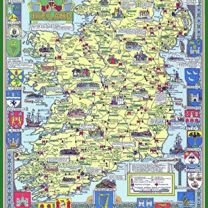
Poster Print : Pictorial History Map of Scotland 1963


![]()
Poster Prints from MapSeeker
Pictorial History Map of Scotland 1963
This is a wonderful pictorial map illustrating the history of Scotland drawn by Leslie Bullock and published in 1963 by Collins Bartholomew as a fold up map. Now re-digitized and re-published by Mapseeker in association with the Collins Bartholomew Archive, the map covers all of Scotland with historical locations and events illustrated pictorially in the form of charming cartoon vignettes. The map is surrounded by the armorial crests of Scotland
Welcome to the Mapseeker Image library and enter an historic gateway to one of the largest on-line collections of Historic Maps, Nostalgic Views, Vista's and Panorama's from a World gone by.
Media ID 20347983
A2 (59.4 x 42cm) Poster Print
Step back in time with our Media Storehouse Poster Prints featuring the captivating "Pictorial History Map of Scotland 1963" from MapSeeker. This vintage masterpiece, created by Leslie Bullock and published by Collins Bartholomew, offers a unique and intriguing perspective on Scotland's rich history. Each detail, from historic sites to scenic landscapes, comes alive in this beautifully illustrated map. Bring a piece of the past into your home or office with this striking and conversational poster print. Perfect for history enthusiasts, educators, or anyone who appreciates the charm of bygone eras. Order yours today and let the story of Scotland unfold before your eyes!
A2 Poster (59.4 x 42cm, 23.4" x 16.5" inches) printed on 170gsm Satin Poster Paper. Securely packaged, rolled and inserted into a strong mailing tube and shipped tracked. Poster Prints are of comparable archival quality to our Photographic prints, they are simply printed on thinner Poster Paper. Whilst we only use Photographic Prints in our frames, you can frame Poster Prints if they are carefully supported to prevent sagging over time.
Poster prints are budget friendly enlarged prints in standard poster paper sizes (A0, A1, A2, A3 etc). Whilst poster paper is sometimes thinner and less durable than our other paper types, they are still ok for framing and should last many years. Our Archival Quality Photo Prints and Fine Art Paper Prints are printed on higher quality paper and the choice of which largely depends on your budget.
Estimated Image Size (if not cropped) is 39.6cm x 59.4cm (15.6" x 23.4")
Estimated Product Size is 42cm x 59.4cm (16.5" x 23.4")
These are individually made so all sizes are approximate
Artwork printed orientated as per the preview above, with portrait (vertical) orientation to match the source image.
FEATURES IN THESE COLLECTIONS
> MapSeeker
> Maps from the British Isles
> Scotland and Counties PORTFOLIO
> MapSeeker
> Pictorial Maps and Pictorial History
> Pictorial History Maps PORTFOLIO
> Animals
> Mammals
> Cats (Domestic)
> Scottish Fold
> Europe
> United Kingdom
> Scotland
> Maps
> Europe
> United Kingdom
> Scotland
> Posters
> Europe
> United Kingdom
> Scotland
> Related Images
> Maps and Charts
> Early Maps
> Maps and Charts
> Related Images
EDITORS COMMENTS
This print showcases the "Pictorial History Map of Scotland 1963" a true gem for history enthusiasts and admirers of Scottish culture. Originally crafted by the talented Leslie Bullock and published by Collins Bartholomew, this fold-up map has been lovingly re-digitized and re-published by MapSeeker in collaboration with the esteemed Collins Bartholomew Archive. Spanning across all regions of Scotland, this remarkable map offers a visually stunning journey through time. Its intricate illustrations depict significant historical locations and events, cleverly brought to life through charming cartoon vignettes. Each vignette serves as a delightful window into Scotland's rich heritage, inviting viewers to immerse themselves in its fascinating past. Adding an extra touch of grandeur, the map is elegantly framed by the armorial crests of Scotland. These symbolic emblems pay homage to the country's noble traditions and heraldic legacy, evoking a sense of pride and reverence for Scottish history. With its meticulous attention to detail and artistic flair, this print captures not only the essence of Scotland but also celebrates the craftsmanship behind cartography itself. Whether displayed in homes or educational institutions, it serves as both an informative resource and a beautiful piece of art that will undoubtedly ignite curiosity about Scotland's captivating past among all who encounter it.
MADE IN THE UK
Safe Shipping with 30 Day Money Back Guarantee
FREE PERSONALISATION*
We are proud to offer a range of customisation features including Personalised Captions, Color Filters and Picture Zoom Tools
SECURE PAYMENTS
We happily accept a wide range of payment options so you can pay for the things you need in the way that is most convenient for you
* Options may vary by product and licensing agreement. Zoomed Pictures can be adjusted in the Basket.