Poster Print > Europe > United Kingdom > England > London > Towns > Welling
Poster Print : Old County Map of Devonshire 1836 by Thomas Moule


![]()
Poster Prints from MapSeeker
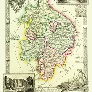
Old County Map of Devonshire 1836 by Thomas Moule
This is a fine decorative reproduction County Map of Devonshire from the First Edition series of Thomas Moule Maps, originally Published in 1836. The well-known series of County Maps which are known as Moules feature beautiful vignette views and were first published in separate sections for each county in 1830-32, they were then published in collected form in a two-volume work: The English Counties Delineated: or a Topographical Description of England: Illustrated by a Complete Series of County Maps by Thomas Moule: London: Published by George Virtue 1836
Welcome to the Mapseeker Image library and enter an historic gateway to one of the largest on-line collections of Historic Maps, Nostalgic Views, Vista's and Panorama's from a World gone by.
Media ID 20348066
© Mapseeker Publishing Ltd
County Map County Map Of England English County Map Historic Map Moule Map Old County Map Old English County Map Old Moule Map Thomas Moule Thomas Moule Map Devonshire
A2 (59.4 x 42cm) Poster Print
Adorn your walls with history and charm with our Media Storehouse Old County Map of Devonshire 1836 by Thomas Moule. This beautifully detailed reproduction, published by Thomas Moule and George Virtue through MapSeeker, showcases an intricately designed map of Devonshire from the First Edition series. Dating back to 1836, this fine decorative print is a captivating reminder of the rich history and culture of Devonshire, making it an excellent addition to any home or office space. Bring a piece of the past into your present with the Old County Map of Devonshire 1836 by Thomas Moule, now available as a high-quality poster print from Media Storehouse.
A2 Poster (59.4 x 42cm, 23.4" x 16.5" inches) printed on 170gsm Satin Poster Paper. Securely packaged, rolled and inserted into a strong mailing tube and shipped tracked. Poster Prints are of comparable archival quality to our Photographic prints, they are simply printed on thinner Poster Paper. Whilst we only use Photographic Prints in our frames, you can frame Poster Prints if they are carefully supported to prevent sagging over time.
Poster prints are budget friendly enlarged prints in standard poster paper sizes (A0, A1, A2, A3 etc). Whilst poster paper is sometimes thinner and less durable than our other paper types, they are still ok for framing and should last many years. Our Archival Quality Photo Prints and Fine Art Paper Prints are printed on higher quality paper and the choice of which largely depends on your budget.
Estimated Image Size (if not cropped) is 52.5cm x 42cm (20.7" x 16.5")
Estimated Product Size is 59.4cm x 42cm (23.4" x 16.5")
These are individually made so all sizes are approximate
Artwork printed orientated as per the preview above, with landscape (horizontal) orientation to match the source image.
FEATURES IN THESE COLLECTIONS
> MapSeeker
> Maps from the British Isles
> England and Counties PORTFOLIO
> Arts
> Artists
> M
> Thomas Moule
> Europe
> United Kingdom
> England
> Devon
> Related Images
> Europe
> United Kingdom
> England
> London
> Towns
> Welling
> Europe
> United Kingdom
> England
> Maps
> Europe
> United Kingdom
> England
> Wells
> Maps and Charts
> Early Maps
> Maps and Charts
> Related Images
> Popular Themes
> Devon
EDITORS COMMENTS
This exquisite print showcases an Old County Map of Devonshire from 1836, meticulously crafted by the renowned cartographer Thomas Moule. Part of his esteemed First Edition series, this decorative reproduction captures the historical charm and intricate details that have made Moule's maps highly sought after. Originally published in separate sections for each county between 1830 and 1832, these maps were later compiled into a two-volume masterpiece titled "The English Counties Delineated: or a Topographical Description of England". The complete collection featured captivating vignette views and was published by George Virtue in London in 1836. Devonshire, known for its picturesque landscapes and rich history, is beautifully depicted on this map. Every town, village, river, and road is intricately illustrated to provide a comprehensive topographical description of the county. This historic piece offers a glimpse into Devonshire's past while showcasing Moule's exceptional craftsmanship. Whether you are an avid collector of antique maps or simply appreciate the beauty of historical cartography, this print is sure to captivate your imagination. Hang it proudly on your wall as a testament to both Devonshire's heritage and Thomas Moule's enduring legacy as one of England's finest mapmakers.
MADE IN THE UK
Safe Shipping with 30 Day Money Back Guarantee
FREE PERSONALISATION*
We are proud to offer a range of customisation features including Personalised Captions, Color Filters and Picture Zoom Tools
SECURE PAYMENTS
We happily accept a wide range of payment options so you can pay for the things you need in the way that is most convenient for you
* Options may vary by product and licensing agreement. Zoomed Pictures can be adjusted in the Basket.