Poster Print > Arts > Photorealistic artworks > Detailed art pieces > Masterful detailing in art
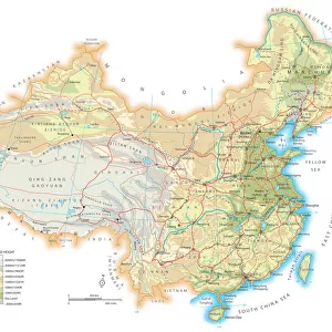
Poster Print : Old Map of China 1852 by Henry George Collins


![]()
Poster Prints from MapSeeker
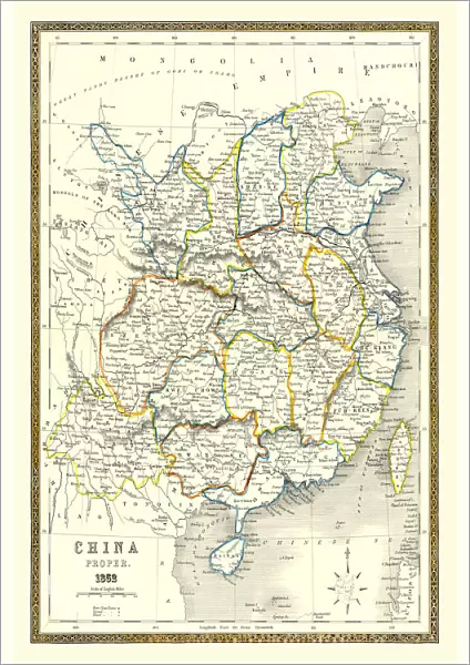
Old Map of China 1852 by Henry George Collins
This is a finely detailed map of China remastered from a rare Atlas of the World published in 1852 by Henry George Collins. Although these Henry Collins produced maps of the highest quality in his time unfortunately not the same could be said in terms of his business success. His maps were later obtained by the famous Stanford Map Company and used in their publications
Welcome to the Mapseeker Image library and enter an historic gateway to one of the largest on-line collections of Historic Maps, Nostalgic Views, Vista's and Panorama's from a World gone by.
Media ID 20347233
© Mapseeker Publishing Ltd
Collins Collins Atlas Collins Atlas Map Collins Map
A2 (59.4 x 42cm) Poster Print
Discover the rich history of China with our exquisite Old Map of China 1852 by Henry George Collins print from Media Storehouse. This finely detailed map, remastered from the rare Atlas of the World published by Henry George Collins, is a stunning addition to any home or office. The intricate depiction of China during this era showcases the historical significance of this ancient civilization. Bring a piece of the past into your present with this beautifully preserved map print.
A2 Poster (59.4 x 42cm, 23.4" x 16.5" inches) printed on 170gsm Satin Poster Paper. Securely packaged, rolled and inserted into a strong mailing tube and shipped tracked. Poster Prints are of comparable archival quality to our Photographic prints, they are simply printed on thinner Poster Paper. Whilst we only use Photographic Prints in our frames, you can frame Poster Prints if they are carefully supported to prevent sagging over time.
Poster prints are budget friendly enlarged prints in standard poster paper sizes (A0, A1, A2, A3 etc). Whilst poster paper is sometimes thinner and less durable than our other paper types, they are still ok for framing and should last many years. Our Archival Quality Photo Prints and Fine Art Paper Prints are printed on higher quality paper and the choice of which largely depends on your budget.
Estimated Image Size (if not cropped) is 39.6cm x 59.4cm (15.6" x 23.4")
Estimated Product Size is 42cm x 59.4cm (16.5" x 23.4")
These are individually made so all sizes are approximate
Artwork printed orientated as per the preview above, with portrait (vertical) orientation to match the source image.
FEATURES IN THESE COLLECTIONS
> MapSeeker
> Maps of Asia and Middle East
> Maps of Countries in Asia PORTFOLIO
> Arts
> Photorealistic artworks
> Detailed art pieces
> Masterful detailing in art
> Maps and Charts
> Related Images
> Maps and Charts
> World
EDITORS COMMENTS
This beautifully restored print showcases an exquisite piece of cartographic history - the "Old Map of China 1852" by Henry George Collins. Created with meticulous attention to detail, this map is a testament to Collins' exceptional craftsmanship during his time. Unfortunately, despite his undeniable talent, Collins did not achieve the same level of success in business. However, fate had other plans for these remarkable maps. The renowned Stanford Map Company recognized their value and acquired them for use in their own publications. This collaboration ensured that Collins' work would continue to be appreciated and shared with future generations. The "Old Map of China 1852" offers a captivating glimpse into the past, revealing the intricate geography and rich cultural heritage of China during that era. From its vibrant cities to its sprawling landscapes, every corner is meticulously depicted on this historic artifact. Whether you are an avid collector or simply fascinated by Chinese history, this print will transport you back in time and allow you to explore the wonders of old China from the comfort of your own home. Display it proudly as a conversation starter or use it as a valuable resource for research and study. Henry George Collins may not have achieved commercial success during his lifetime, but his legacy lives on through this extraordinary map - now available for all those who appreciate fine cartography and cherish our world's diverse history.
MADE IN THE UK
Safe Shipping with 30 Day Money Back Guarantee
FREE PERSONALISATION*
We are proud to offer a range of customisation features including Personalised Captions, Color Filters and Picture Zoom Tools
SECURE PAYMENTS
We happily accept a wide range of payment options so you can pay for the things you need in the way that is most convenient for you
* Options may vary by product and licensing agreement. Zoomed Pictures can be adjusted in the Basket.