Poster Print > Europe > United Kingdom > England > Devon > Stonehouse
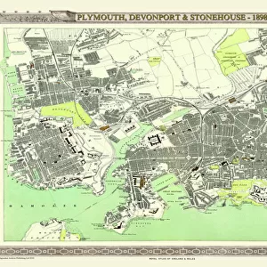
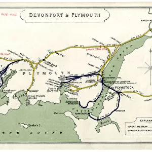
Poster Print : Old Map of Plymouth Devonport and Stonehouse 1851 by John Tallis


![]()
Poster Prints from MapSeeker
Old Map of Plymouth Devonport and Stonehouse 1851 by John Tallis
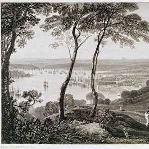
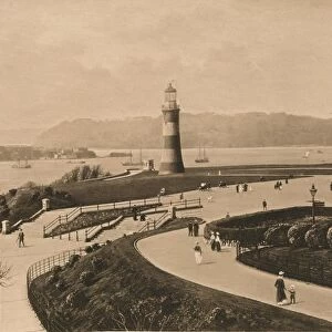
An attractive Victorian plan of Plymouth in Devon by John Tallis 1851, with Morice Town, Higher Stoke, Stoke, Devonport and Stonehouse. There are three illustrations on the plan of Plymouth, the Column, a view across Plymouth Sound and a busy scene across to Plymouth and the famous Citadel
Welcome to the Mapseeker Image library and enter an historic gateway to one of the largest on-line collections of Historic Maps, Nostalgic Views, Vista's and Panorama's from a World gone by.
Media ID 20347632
Historic Map John Tallis John Tallis Map Old Town Plan Tallis Map Devonport Plymouth Stonehouse
A2 (59.4 x 42cm) Poster Print
"Step back in time with our exquisite selection of Media Storehouse Poster Prints, featuring an enchanting Old Map of Plymouth Devonport and Stonehouse, dating back to 1851. Meticulously reproduced from the original John Tallis map, this captivating Victorian plan brings to life the historic charm of Plymouth. Discover Morice Town, Higher Stoke, Stoke, Devonport, and Stonehouse as they once were, with intricate detail and stunning accuracy. Bring a piece of history into your home or office with our high-quality, museum-grade poster prints. Perfect for those who appreciate the beauty of antique maps and the rich history of Plymouth."
A2 Poster (59.4 x 42cm, 23.4" x 16.5" inches) printed on 170gsm Satin Poster Paper. Securely packaged, rolled and inserted into a strong mailing tube and shipped tracked. Poster Prints are of comparable archival quality to our Photographic prints, they are simply printed on thinner Poster Paper. Whilst we only use Photographic Prints in our frames, you can frame Poster Prints if they are carefully supported to prevent sagging over time.
Poster prints are budget friendly enlarged prints in standard poster paper sizes (A0, A1, A2, A3 etc). Whilst poster paper is sometimes thinner and less durable than our other paper types, they are still ok for framing and should last many years. Our Archival Quality Photo Prints and Fine Art Paper Prints are printed on higher quality paper and the choice of which largely depends on your budget.
Estimated Image Size (if not cropped) is 59.4cm x 39.6cm (23.4" x 15.6")
Estimated Product Size is 59.4cm x 42cm (23.4" x 16.5")
These are individually made so all sizes are approximate
Artwork printed orientated as per the preview above, with landscape (horizontal) orientation to match the source image.
FEATURES IN THESE COLLECTIONS
> MapSeeker
> British Town And City Plans
> English & Welsh PORTFOLIO
> Arts
> Artists
> T
> John Tallis
> Europe
> United Kingdom
> England
> Devon
> Devonport
> Europe
> United Kingdom
> England
> Devon
> Plymouth
> Europe
> United Kingdom
> England
> Devon
> Related Images
> Europe
> United Kingdom
> England
> Devon
> Stoke
> Europe
> United Kingdom
> England
> Devon
> Stonehouse
> Maps and Charts
> Related Images
> Popular Themes
> Devon
EDITORS COMMENTS
This Victorian print showcases an exquisite old map of Plymouth, Devonport, and Stonehouse in 1851. Created by the talented cartographer John Tallis, this intricate town plan offers a glimpse into the rich history of these charming English towns. The map features various notable locations such as Morice Town, Higher Stoke, Stoke, Devonport, and Stonehouse. Three stunning illustrations adorn the plan: The Column stands tall as a symbol of strength and resilience; a breathtaking view across Plymouth Sound captures the beauty of its coastal landscape; and a bustling scene depicts life in Plymouth with its famous Citadel standing proudly in the background. Transporting us back to another era, this historic map provides valuable insights into how these areas were laid out during Victorian times. It is not only a fascinating piece for collectors or enthusiasts but also serves as an educational resource for those interested in local history. Whether you are exploring your ancestry or simply appreciating the artistry behind antique maps, this print offers a unique opportunity to delve into the past and discover more about the vibrant city of Plymouth and its surrounding neighborhoods - Devonport and Stonehouse.
MADE IN THE UK
Safe Shipping with 30 Day Money Back Guarantee
FREE PERSONALISATION*
We are proud to offer a range of customisation features including Personalised Captions, Color Filters and Picture Zoom Tools
SECURE PAYMENTS
We happily accept a wide range of payment options so you can pay for the things you need in the way that is most convenient for you
* Options may vary by product and licensing agreement. Zoomed Pictures can be adjusted in the Basket.