Glass Frame > Europe > United Kingdom > England > Devon > Stonehouse
Glass Frame : Old Map of Plymouth Devonport and Stonehouse 1851 by John Tallis


![]()
Mounted Prints from MapSeeker
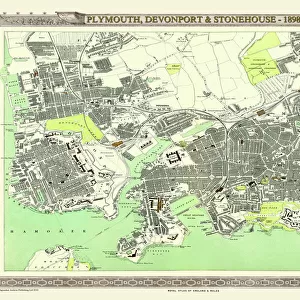
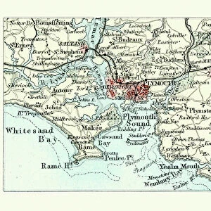
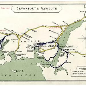
Old Map of Plymouth Devonport and Stonehouse 1851 by John Tallis
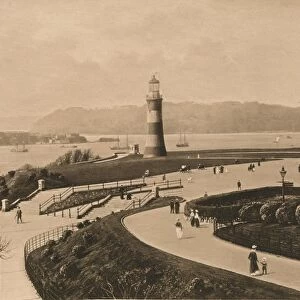
An attractive Victorian plan of Plymouth in Devon by John Tallis 1851, with Morice Town, Higher Stoke, Stoke, Devonport and Stonehouse. There are three illustrations on the plan of Plymouth, the Column, a view across Plymouth Sound and a busy scene across to Plymouth and the famous Citadel
Welcome to the Mapseeker Image library and enter an historic gateway to one of the largest on-line collections of Historic Maps, Nostalgic Views, Vista's and Panorama's from a World gone by.
Media ID 20347632
Historic Map John Tallis John Tallis Map Old Town Plan Tallis Map Devonport Plymouth Stonehouse
7"x5" Glass Mount
Wall mounted or free-standing, these black edged glass frames feature a smooth chamfered edge and a stylish black border (on back face of the glass). Manufactured from 4mm thick glass, Glass Mounts are a durable, professional way of displaying and protecting your prints. Your 7x5 print is slotted into the back of the frame so can easily be changed if needed.
Tempered Glass Mounts are ideal for wall display, plus the smaller sizes can also be used free-standing via an integral stand
Estimated Image Size (if not cropped) is 17.7cm x 12.7cm (7" x 5")
Estimated Product Size is 20.3cm x 16.2cm (8" x 6.4")
These are individually made so all sizes are approximate
Artwork printed orientated as per the preview above, with landscape (horizontal) orientation to match the source image.
FEATURES IN THESE COLLECTIONS
> Arts
> Artists
> T
> John Tallis
> Europe
> United Kingdom
> England
> Devon
> Devonport
> Europe
> United Kingdom
> England
> Devon
> Plymouth
> Europe
> United Kingdom
> England
> Devon
> Related Images
> Europe
> United Kingdom
> England
> Devon
> Stoke
> Europe
> United Kingdom
> England
> Devon
> Stonehouse
> Maps and Charts
> Related Images
> Popular Themes
> Devon
> MapSeeker
> British Town And City Plans
> English & Welsh PORTFOLIO
EDITORS COMMENTS
This Victorian print showcases an exquisite old map of Plymouth, Devonport, and Stonehouse in 1851. Created by the talented cartographer John Tallis, this intricate town plan offers a glimpse into the rich history of these charming English towns. The map features various notable locations such as Morice Town, Higher Stoke, Stoke, Devonport, and Stonehouse. Three stunning illustrations adorn the plan: The Column stands tall as a symbol of strength and resilience; a breathtaking view across Plymouth Sound captures the beauty of its coastal landscape; and a bustling scene depicts life in Plymouth with its famous Citadel standing proudly in the background. Transporting us back to another era, this historic map provides valuable insights into how these areas were laid out during Victorian times. It is not only a fascinating piece for collectors or enthusiasts but also serves as an educational resource for those interested in local history. Whether you are exploring your ancestry or simply appreciating the artistry behind antique maps, this print offers a unique opportunity to delve into the past and discover more about the vibrant city of Plymouth and its surrounding neighborhoods - Devonport and Stonehouse.
MADE IN THE UK
Safe Shipping with 30 Day Money Back Guarantee
FREE PERSONALISATION*
We are proud to offer a range of customisation features including Personalised Captions, Color Filters and Picture Zoom Tools
SECURE PAYMENTS
We happily accept a wide range of payment options so you can pay for the things you need in the way that is most convenient for you
* Options may vary by product and licensing agreement. Zoomed Pictures can be adjusted in the Basket.