Poster Print > Arts > Artists > S > John Speed
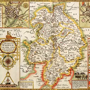
Poster Print : Kent Historical John Speed 1610 Map


![]()
Poster Prints from Map Marketing
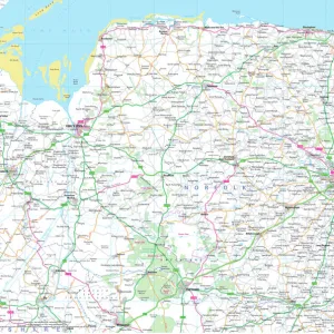
Kent Historical John Speed 1610 Map
A reproduction of John Speeds historical map of the county of Kent. Originally published as part of his atlas called The Theatre of the Empire of Great Britain in 1610. John Speed ((1552-1629) was a renowned English cartographer, his maps themselves were of high quality and gained a great reputation for being among the best county maps
Media ID 19950673
© Map Marketing Ltd
1610 Historical Map John Speed Kent
A2 (59.4 x 42cm) Poster Print
A2 Poster (59.4 x 42cm, 23.4" x 16.5" inches) printed on 170gsm Satin Poster Paper. Securely packaged, rolled and inserted into a strong mailing tube and shipped tracked. Poster Prints are of comparable archival quality to our Photographic prints, they are simply printed on thinner Poster Paper. Whilst we only use Photographic Prints in our frames, you can frame Poster Prints if they are carefully supported to prevent sagging over time.
Poster prints are budget friendly enlarged prints in standard poster paper sizes (A0, A1, A2, A3 etc). Whilst poster paper is sometimes thinner and less durable than our other paper types, they are still ok for framing and should last many years. Our Archival Quality Photo Prints and Fine Art Paper Prints are printed on higher quality paper and the choice of which largely depends on your budget.
Estimated Image Size (if not cropped) is 55cm x 42cm (21.7" x 16.5")
Estimated Product Size is 59.4cm x 42cm (23.4" x 16.5")
These are individually made so all sizes are approximate
Artwork printed orientated as per the preview above, with landscape (horizontal) orientation to match the source image.
FEATURES IN THESE COLLECTIONS
> Arts
> Artists
> S
> John Speed
> Maps and Charts
> British Empire Maps
> Maps and Charts
> Early Maps
> Maps and Charts
> Related Images
MADE IN THE UK
Safe Shipping with 30 Day Money Back Guarantee
FREE PERSONALISATION*
We are proud to offer a range of customisation features including Personalised Captions, Color Filters and Picture Zoom Tools
SECURE PAYMENTS
We happily accept a wide range of payment options so you can pay for the things you need in the way that is most convenient for you
* Options may vary by product and licensing agreement. Zoomed Pictures can be adjusted in the Basket.