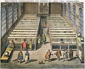
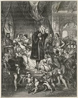
Fraud Blocker Skip to main content

1610 Collection

"Exploring the Past: Unveiling the Treasures of 1610" Step back in time to the year 1610

Background image1610 Collection: Lancashire Historical John Speed 1610 Map

Lancashire Historical John Speed 1610 Map
A reproduction of John Speeds historical map of the county of Lancashire. Originally published as part of his atlas called The Theatre of the Empire of Great Britain in 1610

Background image1610 Collection: GALILEO: MOON. Sketches by Galileo of the moon as he saw it through the telescope

GALILEO: MOON. Sketches by Galileo of the moon as he saw it through the telescope, from his book The Starry Messenger, 1610

Background image1610 Collection: Kent Historical John Speed 1610 Map

Kent Historical John Speed 1610 Map
A reproduction of John Speeds historical map of the county of Kent. Originally published as part of his atlas called The Theatre of the Empire of Great Britain in 1610

Background image1610 Collection: Yorkshire Historical John Speed 1610 Map

Yorkshire Historical John Speed 1610 Map
A reproduction of John Speeds historical map of the county of Yorkshire. Originally published as part of his atlas called The Theatre of the Empire of Great Britain in 1610

Background image1610 Collection: Somerset Historical John Speed 1610 Map

Somerset Historical John Speed 1610 Map
A reproduction of John Speeds historical map of the county of Somerset. Originally published as part of his atlas called The Theatre of the Empire of Great Britain in 1610

Background image1610 Collection: Pembrokeshire Historical John Speed 1610 Map

Pembrokeshire Historical John Speed 1610 Map
A reproduction of John Speeds historical map of the county of Pembrokeshire. Originally published as part of his atlas called The Theatre of the Empire of Great Britain in 1610

Background image1610 Collection: Oxfordshire Historical John Speed 1610 Map

Oxfordshire Historical John Speed 1610 Map
A reproduction of John Speeds historical map of the county of Oxfordshire. Originally published as part of his atlas called The Theatre of the Empire of Great Britain in 1610

Background image1610 Collection: Yorkshire West Riding Historical John Speed 1610 Map

Yorkshire West Riding Historical John Speed 1610 Map
A reproduction of John Speeds historical map of the county of West Yorkshire. Originally published as part of his atlas called The Theatre of the Empire of Great Britain in 1610

Background image1610 Collection: Lincolnshire Historical John Speed 1610 Map

Lincolnshire Historical John Speed 1610 Map
A reproduction of John Speeds historical map of the county of Lincolnshire. Originally published as part of his atlas called The Theatre of the Empire of Great Britain in 1610

Background image1610 Collection: Northumberland Historical John Speed 1610 Map

Northumberland Historical John Speed 1610 Map
A reproduction of John Speeds historical map of the county of Northumberland. Originally published as part of his atlas called The Theatre of the Empire of Great Britain in 1610

Background image1610 Collection: Nottinghamshire Historical John Speed 1610 Map

Nottinghamshire Historical John Speed 1610 Map
A reproduction of John Speeds historical map of the county of Nottinghamshire. Originally published as part of his atlas called The Theatre of the Empire of Great Britain in 1610

Background image1610 Collection: Cornwall Historical John Speed 1610 Map

Cornwall Historical John Speed 1610 Map
A reproduction of John Speeds historical map of the county of Cornwall. Originally published as part of his atlas called The Theatre of the Empire of Great Britain in 1610

Background image1610 Collection: Sussex Historical John Speed 1610 Map

Sussex Historical John Speed 1610 Map
A reproduction of John Speeds historical map of the county of Sussex. Originally published as part of his atlas called The Theatre of the Empire of Great Britain in 1610

Background image1610 Collection: Surrey Historical John Speed 1610 Map

Surrey Historical John Speed 1610 Map
A reproduction of John Speeds historical map of the county of Surrey. Originally published as part of his atlas called The Theatre of the Empire of Great Britain in 1610

Background image1610 Collection: Isle of Wight Historical John Speed 1610 Map

Isle of Wight Historical John Speed 1610 Map
A reproduction of John Speeds historical map of the county of Isle of Wight. Originally published as part of his atlas called The Theatre of the Empire of Great Britain in 1610

Background image1610 Collection: ST. CECILIA AND AN ANGEL. Canvas, c1610, by Orazio Gentileschi

ST. CECILIA AND AN ANGEL. Canvas, c1610, by Orazio Gentileschi

Background image1610 Collection: The Crucifixion of St. Peter

The Crucifixion of St. Peter

Background image1610 Collection: Galileos Jovian moon observations, 1610

Galileos Jovian moon observations, 1610
Galileos Jovian moon observations. These first six observations of the four largest moons of Jupiter are from the work Sidereus Nuncius (1610) by the Italian astronomer Galileo Galilei (1564-1642)

Background image1610 Collection: The Winters Tale

The Winters Tale
Leontes is astonished by the lifelike nature of the statue of Hermione : Paulina, too, is enraptured

Background image1610 Collection: Leicestershire Historical John Speed 1610 Map

Leicestershire Historical John Speed 1610 Map
A reproduction of John Speeds historical map of the county of Leicestershire. Originally published as part of his atlas called The Theatre of the Empire of Great Britain in 1610

Background image1610 Collection: Norfolk Historical John Speed 1610 Map

Norfolk Historical John Speed 1610 Map
A reproduction of John Speeds historical map of the county of Norfolk. Originally published as part of his atlas called The Theatre of the Empire of Great Britain in 1610

Background image1610 Collection: Suffolk Historical John Speed 1610 Map

Suffolk Historical John Speed 1610 Map
A reproduction of John Speeds historical map of the county of Suffolk. Originally published as part of his atlas called The Theatre of the Empire of Great Britain in 1610

Background image1610 Collection: Rutland Historical John Speed 1610 Map

Rutland Historical John Speed 1610 Map
A reproduction of John Speeds historical map of the county of Rutland. Originally published as part of his atlas called The Theatre of the Empire of Great Britain in 1610

Background image1610 Collection: Devon Historical John Speed 1610 Map

Devon Historical John Speed 1610 Map
A reproduction of John Speeds historical map of the county of Devon. Originally published as part of his atlas called The Theatre of the Empire of Great Britain in 1610

Background image1610 Collection: Durham Historical John Speed 1610 Map

Durham Historical John Speed 1610 Map
A reproduction of John Speeds historical map of the county of Durham. Originally published as part of his atlas called The Theatre of the Empire of Great Britain in 1610

Background image1610 Collection: Flintshire Historical John Speed 1610 Map

Flintshire Historical John Speed 1610 Map
A reproduction of John Speeds historical map of the county of Flintshire. Originally published as part of his atlas called The Theatre of the Empire of Great Britain in 1610

Background image1610 Collection: Cambridgeshire Historical John Speed 1610 Map

Cambridgeshire Historical John Speed 1610 Map
A reproduction of John Speeds historical map of the county of Cambridgeshire. Originally published as part of his atlas called The Theatre of the Empire of Great Britain in 1610

Background image1610 Collection: Gloucestershire Historical John Speed 1610 Map

Gloucestershire Historical John Speed 1610 Map
A reproduction of John Speeds historical map of the county of Gloucestershire. Originally published as part of his atlas called The Theatre of the Empire of Great Britain in 1610

Background image1610 Collection: Cadmus sowing dragons teeth, workshop of Peter Paul Rubens, 1610 - 1690

Cadmus sowing dragons teeth, workshop of Peter Paul Rubens, 1610 - 1690

Background image1610 Collection: LEYDEN: LIBRARY, 1610. Interior of the library of the University of Leyden in the Netherlands

LEYDEN: LIBRARY, 1610. Interior of the library of the University of Leyden in the Netherlands. Colored engraving, 1610, by Jan Cornelis Woudanus

Background image1610 Collection: Henri Iv, his Birth

Henri Iv, his Birth
HENRI IV, KING OF FRANCE his birth : his mother, Jeanne d Albret, queen of Navarre, is surrounded by courtiers, but the jester doesn t seem at all interested, nor does the dog

Background image1610 Collection: Henri IV of France

Henri IV of France
HENRI IV, King of France and Navarre

Background image1610 Collection: Middlesex Historical John Speed 1610 Map

Middlesex Historical John Speed 1610 Map
A reproduction of John Speeds historical map of the county of Middlesex. Originally published as part of his atlas called The Theatre of the Empire of Great Britain in 1610

Background image1610 Collection: Worcestershire Historical John Speed 1610 Map

Worcestershire Historical John Speed 1610 Map
A reproduction of John Speeds historical map of the county of Worcestershire. Originally published as part of his atlas called The Theatre of the Empire of Great Britain in 1610

Background image1610 Collection: Yorkshire North & East Riding Historical John Speed 1610 Map

Yorkshire North & East Riding Historical John Speed 1610 Map
A reproduction of John Speeds historical map of the county of North Yorkshire & the East Riding. Originally published as part of his atlas called The Theatre of the Empire of Great Britain in 1610

Background image1610 Collection: Northamptonshire Historical John Speed 1610 Map

Northamptonshire Historical John Speed 1610 Map
A reproduction of John Speeds historical map of the county of Northamptonshire. Originally published as part of his atlas called The Theatre of the Empire of Great Britain in 1610

Background image1610 Collection: Shropshire Historical John Speed 1610 Map

Shropshire Historical John Speed 1610 Map
A reproduction of John Speeds historical map of the county of Shropshire. Originally published as part of his atlas called The Theatre of the Empire of Great Britain in 1610

Background image1610 Collection: Buckinghamshire Historical John Speed 1610 Map

Buckinghamshire Historical John Speed 1610 Map
A reproduction of John Speeds historical map of the county of Buckinghamshire. Originally published as part of his atlas called The Theatre of the Empire of Great Britain in 1610

Background image1610 Collection: Derbyshire Historical John Speed 1610 Map

Derbyshire Historical John Speed 1610 Map
A reproduction of John Speeds historical map of the county of Derbyshire. Originally published as part of his atlas called The Theatre of the Empire of Great Britain in 1610

Background image1610 Collection: Cheshire Historical John Speed 1610 Map

Cheshire Historical John Speed 1610 Map
A reproduction of John Speeds historical map of the county of Cheshire. Originally published as part of his atlas called The Theatre of the Empire of Great Britain in 1610

Background image1610 Collection: Glamorgan Historical John Speed 1610 Map

Glamorgan Historical John Speed 1610 Map
A reproduction of John Speeds historical map of the county of Glamorgan. Originally published as part of his atlas called The Theatre of the Empire of Great Britain in 1610

Background image1610 Collection: Dorset Historical John Speed 1610 Map

Dorset Historical John Speed 1610 Map
A reproduction of John Speeds historical map of the county of Dorset. Originally published as part of his atlas called The Theatre of the Empire of Great Britain in 1610

Background image1610 Collection: 17th Century (1610) Map of Merionethshire

17th Century (1610) Map of Merionethshire

Background image1610 Collection: 17th Century (1610) Map of Caernarvon Caernarvonshire

17th Century (1610) Map of Caernarvon Caernarvonshire

Background image1610 Collection: Christ embracing the Cross, 1610-1620, by Guido Reni

Christ embracing the Cross, 1610-1620, by Guido Reni
Guido Reni (1575-1642). Italian painter. Christ embracing the Cross, 1610-1620. San Fernando Royal Academy of Fine Arts. Madrid. Spain. Date: 2019

Background image1610 Collection: SIEGE OF JULICH

SIEGE OF JULICH
When the ruler of Julich dies his lands are contested by Dutch and Empire. Imperial forces seize the town but they are besieged and ousted by the Dutch and their allies. Date: 1610

Background image1610 Collection: DOROTHY WADHAM

DOROTHY WADHAM widow of Nicholas Wadham, Somerset landowner, who at his death founded Wadham College, Oxford, despite opposition, 1610 - 1613, Date: 1532 ? - 1618?

Background image1610 Collection: SIR EDMUND FORTESCUE

SIR EDMUND FORTESCUE Royalist military commander, died in exile in Holland after the death of Charles I. Date: 1610 - 1647


All Professionally Made to Order for Quick Shipping

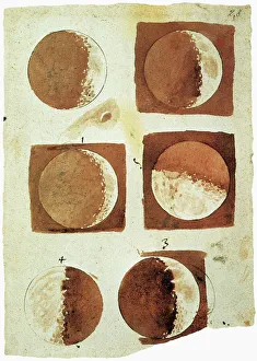
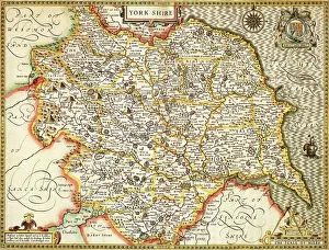
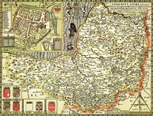
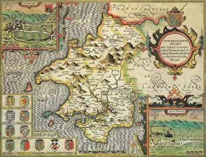
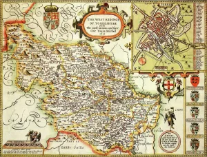
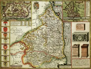
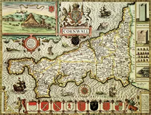
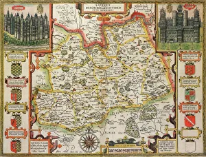
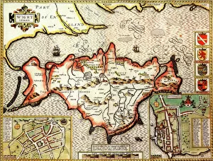
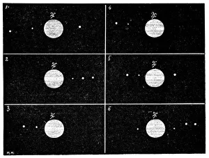
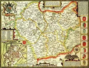
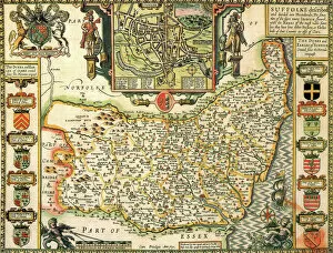
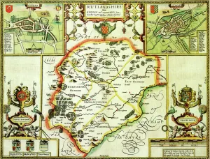
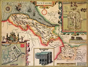
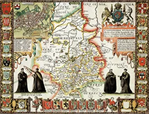
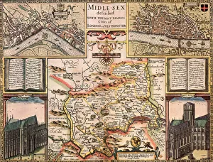
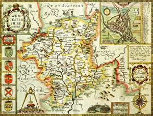
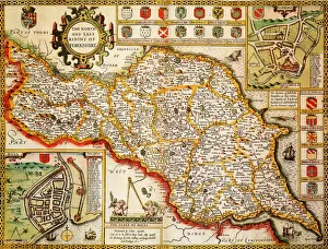
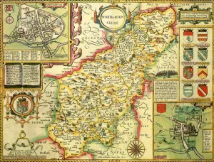
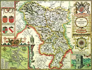
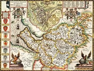
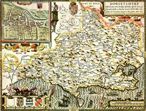
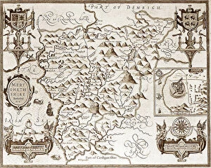
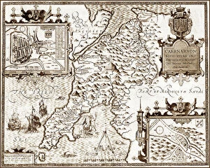
"Exploring the Past: Unveiling the Treasures of 1610" Step back in time to the year 1610, a pivotal era in history captured through various historical maps and astronomical sketches. Lancashire, Kent, Yorkshire, Somerset, Lincolnshire, Nottinghamshire - these regions come alive as we delve into John Speed's meticulously crafted maps from this significant period. The Lancashire Historical John Speed 1610 Map reveals a landscape brimming with rich heritage and captivating stories waiting to be uncovered. From bustling towns to sprawling countryside, every corner holds secrets of bygone days. Venturing southwards to Kent on the Historical John Speed 1610 Map unveils an enchanting tapestry of picturesque villages and ancient castles. This map serves as a gateway into a world where knights once roamed and tales of chivalry were woven. In Galileo's groundbreaking book The Starry Messenger (1610), his sketches of the moon offer us a glimpse into his revolutionary observations made through his telescope. These intricate drawings transport us to an age when humanity first began unraveling the mysteries beyond our planet. Yorkshire West Riding also finds its place on John Speed's Historical Map from 1610. Here lies a land steeped in tradition and folklore; each village tells its own unique tale that echoes through generations. Travel further eastward to Lincolnshire on another one of Speed's historical maps from this era. Discover hidden gems amidst vast landscapes dotted with charming market towns and majestic cathedrals that stand as testaments to centuries-old craftsmanship. Nottinghamshire beckons explorers with its intriguing blend of medieval architecture showcased on yet another map by John Speed dating back to 1610. Immerse yourself in legends surrounding Sherwood Forest or trace Robin Hood's footsteps across this storied county. Cornwall awaits adventurers seeking rugged coastlines and mythical tales etched deep within its soul according to Cornwall Historical John Speed 1610 Map.