Poster Print > Liszt Collection > Engravings
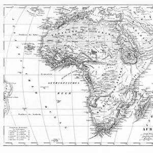
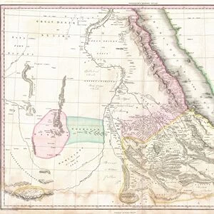
Poster Print : Map of Senegal, Sudan and Guinea, 1896


![]()
Poster Prints from Liszt Collection
Map of Senegal, Sudan and Guinea, 1896
Liszt Collection of nineteenth-century engravings and images to browse and enjoy
Media ID 12977285
© Quint Lox Limited
1896 Guinea Plan Senegal Sudan Chart
A2 (59.4 x 42cm) Poster Print
Step back in time with our vintage Map of Senegal, Sudan, and Guinea, dated 1896 from the esteemed Liszt Collection. This captivating poster print showcases intricate cartographic details of the regions during a pivotal era in world history. Ideal for history buffs, geography enthusiasts, or anyone seeking a touch of nostalgia, this poster print makes a striking addition to any wall space. Bring a piece of the past into your present with Media Storehouse's authentic and high-quality reproductions.
A2 Poster (59.4 x 42cm, 23.4" x 16.5" inches) printed on 170gsm Satin Poster Paper. Securely packaged, rolled and inserted into a strong mailing tube and shipped tracked. Poster Prints are of comparable archival quality to our Photographic prints, they are simply printed on thinner Poster Paper. Whilst we only use Photographic Prints in our frames, you can frame Poster Prints if they are carefully supported to prevent sagging over time.
Poster prints are budget friendly enlarged prints in standard poster paper sizes (A0, A1, A2, A3 etc). Whilst poster paper is sometimes thinner and less durable than our other paper types, they are still ok for framing and should last many years. Our Archival Quality Photo Prints and Fine Art Paper Prints are printed on higher quality paper and the choice of which largely depends on your budget.
Estimated Product Size is 59.4cm x 42cm (23.4" x 16.5")
These are individually made so all sizes are approximate
Artwork printed orientated as per the preview above, with landscape (horizontal) orientation to match the source image.
EDITORS COMMENTS
This print showcases a remarkable piece of history, the "Map of Senegal, Sudan and Guinea, 1896". Transporting us back to the enchanting landscapes of the late nineteenth century, this engraved image is a testament to the illustrative techniques and artistic prowess of that era. The intricate engravement captures every minute detail with precision and skill. The map itself offers a fascinating glimpse into the geographical boundaries and topography of Senegal, Sudan, and Guinea during this period. It serves as an invaluable resource for historians and enthusiasts alike who seek to understand the region's rich cultural heritage. With its retro-styled vintage appeal, this print exudes an air of nostalgia that effortlessly transports us to bygone times. Its Victorian charm adds depth to any space it graces while evoking curiosity about our shared past. Whether displayed in a study or art gallery setting, it becomes an instant conversation starter. Courtesy of Arkheia's Liszt Collection comes yet another masterpiece that seamlessly blends arts and culture with historical significance. This print not only celebrates these three African nations but also pays homage to the illustrators who meticulously crafted such works in days gone by.
MADE IN THE UK
Safe Shipping with 30 Day Money Back Guarantee
FREE PERSONALISATION*
We are proud to offer a range of customisation features including Personalised Captions, Color Filters and Picture Zoom Tools
SECURE PAYMENTS
We happily accept a wide range of payment options so you can pay for the things you need in the way that is most convenient for you
* Options may vary by product and licensing agreement. Zoomed Pictures can be adjusted in the Basket.