Poster Print > Arts > Artists > C > Charles Robert Cockerell
Poster Print : England & Wales in the Winter of 1643-44, 1926. Creators: Unknown, Emery Walker Ltd


![]()
Poster Prints from Heritage Images
England & Wales in the Winter of 1643-44, 1926. Creators: Unknown, Emery Walker Ltd
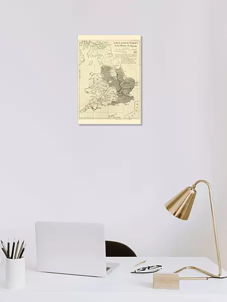
England & Wales in the Winter of 1643-44, 1926. Map showing England and Wales during the Civil War period. The key shows districts held by the king (Charles I), and by parliament. The exact division of England into two allegiances is only very roughly accurate; civil war was swaying to and fro in many of the border districts eg Lancashire, Yorkshire, Lincolnshire and elsewhere. The Eastern Association in 1642 included Essex, Norfolk, Suffolk, Cambridge and Hertfordshire. Huntingdonshire was added in May 1643 and Lincolnshire in September 1643. From " History of England", by George Macaulay Trevelyan. [Longmans, Green and Co. Ltd, London, 1926]
Heritage Images features heritage image collections
Media ID 19044924
© The Print Collector/Heritage Images
Boutall Cartography Charles I Charles I Of England Charles Stuart Civil War Cockerell Cromwell Defender Of The Faith Emery Emery Walker Limited Emery Walker Ltd English Civil War English Civil Wars First English Civil War Green And Co History Of England King Charles I King Of Great Britain And Ireland Longman Longman And Co Longmans Lord Protector Lord Protector Of The Commonwealth Map Making Oliver Oliver Cromwell Parliament Parliamentarian Parliamentarians Roberts And Green Royalist Royalists Trevelyan Walker Walker And Walker And Boutall Walker And Cockerell
A2 (59.4 x 42cm) Poster Print
Step back in time with our captivating England & Wales Poster Print from Media Storehouse. This intriguing map, created by Emery Walker Ltd in 1926, transports you back to the winter of 1643-44 during the English Civil War. Witness the strategic divisions between the districts held by King Charles I and Parliament, as depicted in this beautifully detailed and historically significant artwork. Bring a piece of the past into your home or office and ignite conversations with this unique and enlightening addition to your decor.
A2 Poster (59.4 x 42cm, 23.4" x 16.5" inches) printed on 170gsm Satin Poster Paper. Securely packaged, rolled and inserted into a strong mailing tube and shipped tracked. Poster Prints are of comparable archival quality to our Photographic prints, they are simply printed on thinner Poster Paper. Whilst we only use Photographic Prints in our frames, you can frame Poster Prints if they are carefully supported to prevent sagging over time.
Poster prints are budget friendly enlarged prints in standard poster paper sizes (A0, A1, A2, A3 etc). Whilst poster paper is sometimes thinner and less durable than our other paper types, they are still ok for framing and should last many years. Our Archival Quality Photo Prints and Fine Art Paper Prints are printed on higher quality paper and the choice of which largely depends on your budget.
Estimated Image Size (if not cropped) is 42cm x 53.3cm (16.5" x 21")
Estimated Product Size is 42cm x 59.4cm (16.5" x 23.4")
These are individually made so all sizes are approximate
Artwork printed orientated as per the preview above, with portrait (vertical) orientation to match the source image.
FEATURES IN THESE COLLECTIONS
> Arts
> Artists
> C
> Charles Robert Cockerell
> Arts
> Artists
> C
> King Charles
> Arts
> Artists
> G
> Charles Green
> Arts
> Artists
> W
> Charles White
> Arts
> Artists
> W
> George White
> Arts
> Artists
> W
> Robert Walker
> Arts
> Artists
> W
> Robert White
> Europe
> Republic of Ireland
> Maps
> Europe
> United Kingdom
> England
> Cambridge
> Europe
> United Kingdom
> England
> Essex
> Related Images
EDITORS COMMENTS
This print captures a historical map titled "England & Wales in the Winter of 1643-44,1926". Created by an unknown artist and Emery Walker Ltd, this map depicts England and Wales during the tumultuous period of the Civil War. The key on the map indicates territories held by King Charles I and Parliament, although it should be noted that the division is only roughly accurate due to the constantly shifting nature of the conflict. The image provides a glimpse into a critical moment in British history when civil war ravaged many border districts such as Lancashire, Yorkshire, Lincolnshire, and others. It showcases how different regions aligned themselves with either side throughout this turbulent time. Notably, the Eastern Association in 1642 included Essex, Norfolk, Suffolk, Cambridge, and Hertfordshire before expanding to include Huntingdonshire in May 1643 and Lincolnshire in September of that same year. Taken from George Macaulay Trevelyan's book "History of England" published by Longmans Green and Co. Ltd in London in 1926; this print offers us a valuable visual representation of an era marked by political upheaval and military conflict. The monochrome aesthetic adds a sense of gravitas to this historical document while reminding us of its significance as both artistry and cartography merged seamlessly together. As we gaze upon this image today, we are transported back to seventeenth-century England where royalists clashed with parliamentarians under figures like Oliver Cromwell - Lord Protector of the Commonwealth. This photograph serves as a testament to our enduring fascination with history's defining moments captured through maps like these.
MADE IN THE UK
Safe Shipping with 30 Day Money Back Guarantee
FREE PERSONALISATION*
We are proud to offer a range of customisation features including Personalised Captions, Color Filters and Picture Zoom Tools
SECURE PAYMENTS
We happily accept a wide range of payment options so you can pay for the things you need in the way that is most convenient for you
* Options may vary by product and licensing agreement. Zoomed Pictures can be adjusted in the Basket.