Poster Print > Europe > Republic of Ireland > Maps
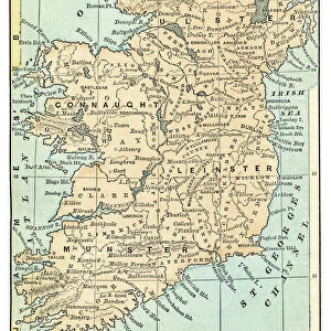
Poster Print : Map of Ireland 1889


![]()
Poster Prints from Fine Art Storehouse
Map of Ireland 1889
Comprehensive Geography by James Monteith - American Book Company 1882, 1889
Unleash your creativity and transform your space into a visual masterpiece!
THEPALMER
Media ID 18357267
A2 (59.4 x 42cm) Poster Print
Discover the rich history of Ireland with our stunning Map of Ireland 1889 print from ThePalmer's Comprehensive Geography, published by the American Book Company in 1882 and 1889. This exquisite poster print transports you back in time, offering a captivating glimpse into the geography of Ireland during the late 19th century. The intricate details of this vintage map are sure to captivate history enthusiasts, geography buffs, and anyone with an appreciation for the beauty of historical cartography. Add this unique piece to your home or office decor and let the stories of the past come alive.
A2 Poster (59.4 x 42cm, 23.4" x 16.5" inches) printed on 170gsm Satin Poster Paper. Securely packaged, rolled and inserted into a strong mailing tube and shipped tracked. Poster Prints are of comparable archival quality to our Photographic prints, they are simply printed on thinner Poster Paper. Whilst we only use Photographic Prints in our frames, you can frame Poster Prints if they are carefully supported to prevent sagging over time.
Poster prints are budget friendly enlarged prints in standard poster paper sizes (A0, A1, A2, A3 etc). Whilst poster paper is sometimes thinner and less durable than our other paper types, they are still ok for framing and should last many years. Our Archival Quality Photo Prints and Fine Art Paper Prints are printed on higher quality paper and the choice of which largely depends on your budget.
Estimated Product Size is 42cm x 59.4cm (16.5" x 23.4")
These are individually made so all sizes are approximate
Artwork printed orientated as per the preview above, with portrait (vertical) orientation to match the source image.
FEATURES IN THESE COLLECTIONS
> Fine Art Storehouse
> Map
> Historical Maps
> Europe
> Republic of Ireland
> Maps
> Maps and Charts
> Related Images
EDITORS COMMENTS
In this print titled "Map of Ireland 1889" we are transported back in time to the late 19th century, where cartography was a true art form. The map, originally featured in James Monteith's Comprehensive Geography published by the American Book Company in 1882 and updated in 1889, showcases the intricate details and craftsmanship that went into creating these historical navigational tools. As our eyes wander across the image, we are immediately drawn to the rich colors and fine lines that outline every contour of Ireland's landscape. From its jagged coastlines to its rolling hills and majestic mountains, this map beautifully captures both the geography and topography of this enchanting island nation. The careful placement of cities, towns, rivers, and lakes provides us with a glimpse into Ireland's past; it allows us to imagine what life might have been like during that era. As we examine each region closely, we can almost hear echoes from history whispering tales of ancient Celtic traditions or stories about Irish folklore passed down through generations. "The Map of Ireland 1889" is not just a mere representation of geographical boundaries; it is an invitation for exploration. It beckons us to embark on a journey through time as we trace our fingers along forgotten roads or follow winding rivers towards hidden treasures waiting to be discovered. This remarkable piece by THEPALMER serves as both an educational tool for those interested in history and geography while also being a stunning work of art that captivates viewers with its
MADE IN THE UK
Safe Shipping with 30 Day Money Back Guarantee
FREE PERSONALISATION*
We are proud to offer a range of customisation features including Personalised Captions, Color Filters and Picture Zoom Tools
SECURE PAYMENTS
We happily accept a wide range of payment options so you can pay for the things you need in the way that is most convenient for you
* Options may vary by product and licensing agreement. Zoomed Pictures can be adjusted in the Basket.