Poster Print > Fine Art Storehouse > Map
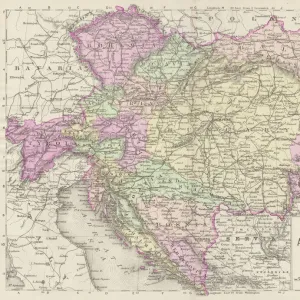
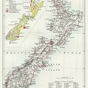
Poster Print : West Russia and Baltic provinces


![]()
Poster Prints from Fine Art Storehouse
West Russia and Baltic provinces
Unleash your creativity and transform your space into a visual masterpiece!
Nastasic
Media ID 13593365
© Nikola Nastasic
1830 1839 78279 95839 Baltic Countries Baltic Sea Biological Culture Black Sea Chart Crimea Eastern Europe Equipment Geographical Locations Image Created 1830 1839 Image Date Moscow Moscow Russia Navigational Equipment Provinces Russia Russian Culture South Caucasus Styles Ukraine Image Created 19th Century Novgorod Obsolete Retro Styled Transcaucasia Victorian Style Volgograd
A2 (59.4 x 42cm) Poster Print
Introducing the captivating 'West Russia and Baltic Provinces' poster print by Nastasic, now available in the Media Storehouse Fine Art collection. This exquisite piece transports you to a bygone era with its intricate details and vibrant colors. The rich history and culture of West Russia and the Baltic provinces come alive in every brushstroke, making this poster a stunning addition to any home or office. Bring a touch of timeless beauty to your space with the 'West Russia and Baltic Provinces' poster print by Nastasic from Media Storehouse.
A2 Poster (59.4 x 42cm, 23.4" x 16.5" inches) printed on 170gsm Satin Poster Paper. Securely packaged, rolled and inserted into a strong mailing tube and shipped tracked. Poster Prints are of comparable archival quality to our Photographic prints, they are simply printed on thinner Poster Paper. Whilst we only use Photographic Prints in our frames, you can frame Poster Prints if they are carefully supported to prevent sagging over time.
Poster prints are budget friendly enlarged prints in standard poster paper sizes (A0, A1, A2, A3 etc). Whilst poster paper is sometimes thinner and less durable than our other paper types, they are still ok for framing and should last many years. Our Archival Quality Photo Prints and Fine Art Paper Prints are printed on higher quality paper and the choice of which largely depends on your budget.
Estimated Image Size (if not cropped) is 42cm x 55.4cm (16.5" x 21.8")
Estimated Product Size is 42cm x 59.4cm (16.5" x 23.4")
These are individually made so all sizes are approximate
Artwork printed orientated as per the preview above, with portrait (vertical) orientation to match the source image.
FEATURES IN THESE COLLECTIONS
> Fine Art Storehouse
> The Magical World of Illustration
> Nastasic Images & Illustrations
> Fine Art Storehouse
> Map
> Historical Maps
EDITORS COMMENTS
This print takes us back in time to the 19th century, showcasing a beautifully detailed map titled "West Russia and Baltic Provinces". The retro-styled cartography, created between 1830 and 1839, exudes an antique charm that transports us to a bygone era. The image captures the rich history and cultural diversity of this region. From Novgorod to Volgograd, from Moscow to Crimea, it encompasses the vast territories of West Russia and Baltic countries in Eastern Europe. The map extends its reach towards Transcaucasia and even includes geographical locations such as the Black Sea and the Baltic Sea. With its Victorian-style illustration, this print not only serves as navigational equipment but also offers insights into Russian culture during that period. It highlights capital cities, provinces, and biological cultures within these regions. As we gaze upon this obsolete yet mesmerizing piece of artistry by Nastasic, we are reminded of how much has changed over time. It allows us to reflect on the past while appreciating our present-day advancements in technology and knowledge. Whether you are a history enthusiast or simply captivated by vintage aesthetics, this print is sure to add character to any space. Let it transport you back in time as you explore the intricate details that make up West Russia and Baltic provinces - a true testament to human curiosity about our world's diverse landscapes.
MADE IN THE UK
Safe Shipping with 30 Day Money Back Guarantee
FREE PERSONALISATION*
We are proud to offer a range of customisation features including Personalised Captions, Color Filters and Picture Zoom Tools
SECURE PAYMENTS
We happily accept a wide range of payment options so you can pay for the things you need in the way that is most convenient for you
* Options may vary by product and licensing agreement. Zoomed Pictures can be adjusted in the Basket.