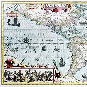
Poster Print > South America > Brazil > Brazil Heritage Sites > Historic Centre of Salvador de Bahia
Poster Print : Geography map: view of the bay of C (Sao Salvador da Bahia de Todos os Santos) from an Atlas (probably by Willem Janszoon Blaeu, 1571-1638) 17th century, Biblioteca Angelica, Rome
 from an Atlas (probably by Willem Janszoon Blaeu, 1571-1638) 17th century, Biblioteca Angelica, Rome")


![]()
Poster Prints From Fine Art Finder
Geography map: view of the bay of C (Sao Salvador da Bahia de Todos os Santos) from an Atlas (probably by Willem Janszoon Blaeu, 1571-1638) 17th century, Biblioteca Angelica, Rome
VEN5030306 Geography map: view of the bay of C (Sao Salvador da Bahia de Todos os Santos) from an Atlas (probably by Willem Janszoon Blaeu, 1571-1638) 17th century, Biblioteca Angelica, Rome; (add.info.: Geography map: view of the bay of C (Sao Salvador da Bahia de Todos os Santos) from an Atlas (probably by Willem Janszoon Blaeu, 1571-1638) 17th century, Biblioteca Angelica, Rome); © Marage Photos
Media ID 38350278
© © Marage Photos / Bridgeman Images
17eme Siecle Amerique Du Nord Amerique Du Sud Brasil Brazil Brazil Brasilian Brazil Brazilian Brazilian Brazilians Bresil Bresilien Bresilienne Carte Geographique Etats Unis Geographie Latin America Stockravenna 17th Centuries Etats Unis Etats Unis Usa United States Geographical Map Latine America
A2 (59.4 x 42cm) Poster Print
"Explore the wonders of the past with our stunning Poster Prints from Media Storehouse! This beautiful print features a 17th-century map of the Bay of All Saints (Sao Salvador da Bahia de Todos os Santos) from an atlas by Willem Janszoon Blaeu, showcasing the intricate details and artistic flair of a bygone era. Printed on high-quality paper, this poster is perfect for history buffs, geography enthusiasts, and anyone who appreciates the beauty of vintage cartography. Bring a touch of nostalgia and sophistication to your home or office with this unique piece."
A2 Poster (59.4 x 42cm, 23.4" x 16.5" inches) printed on 170gsm Satin Poster Paper. Securely packaged, rolled and inserted into a strong mailing tube and shipped tracked. Poster Prints are of comparable archival quality to our Photographic prints, they are simply printed on thinner Poster Paper. Whilst we only use Photographic Prints in our frames, you can frame Poster Prints if they are carefully supported to prevent sagging over time.
Poster prints are budget friendly enlarged prints in standard poster paper sizes (A0, A1, A2, A3 etc). Whilst poster paper is sometimes thinner and less durable than our other paper types, they are still ok for framing and should last many years. Our Archival Quality Photo Prints and Fine Art Paper Prints are printed on higher quality paper and the choice of which largely depends on your budget.
Estimated Image Size (if not cropped) is 59.4cm x 39.6cm (23.4" x 15.6")
Estimated Product Size is 59.4cm x 42cm (23.4" x 16.5")
These are individually made so all sizes are approximate
Artwork printed orientated as per the preview above, with landscape (horizontal) orientation to match the source image.
FEATURES IN THESE COLLECTIONS
> Fine Art Finder
> Artists
> Francois Xavier Fabre
> Arts
> Artists
> B
> Willem Blaeu
> Europe
> Italy
> Lazio
> Rome
> Maps and Charts
> Early Maps
> Maps and Charts
> Related Images
> North America
> El Salvador
> Maps
> North America
> United States of America
> Maps
> South America
> Brazil
> Brazil Heritage Sites
> Historic Centre of Salvador de Bahia
> South America
> Brazil
> Maps
> South America
> Brazil
> Related Images
EDITORS COMMENTS
This stunning 17th-century geography map captures the breathtaking view of the bay of C (Sao Salvador da Bahia de Todos os Santos) from an Atlas, most likely created by Willem Janszoon Blaeu. The intricate details and vibrant colors bring to life this historical representation of South America, specifically Brazil.
The Biblioteca Angelica in Rome houses this remarkable piece, showcasing the beauty and complexity of cartography during this period. The map provides a glimpse into the early exploration and understanding of the New World, highlighting the importance of geography in shaping our understanding of different regions.
As we admire this print, we are transported back in time to a world where discovery and curiosity fueled expeditions across oceans and continents. The meticulous engravings on display serve as a testament to human ingenuity and determination to explore unknown territories.
From the lush landscapes to the intricate coastlines, every detail on this map tells a story of adventure and discovery. It serves as a reminder of how far we have come in our understanding of the world around us while also honoring those who paved the way for future generations to continue exploring and learning about our planet.
MADE IN THE UK
Safe Shipping with 30 Day Money Back Guarantee
FREE PERSONALISATION*
We are proud to offer a range of customisation features including Personalised Captions, Color Filters and Picture Zoom Tools
SECURE PAYMENTS
We happily accept a wide range of payment options so you can pay for the things you need in the way that is most convenient for you
* Options may vary by product and licensing agreement. Zoomed Pictures can be adjusted in the Basket.