Postcard > Arts > Contemporary art > Landscapes > Mountain landscapes
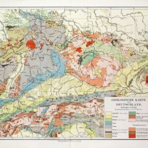
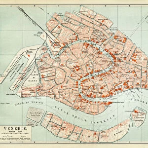
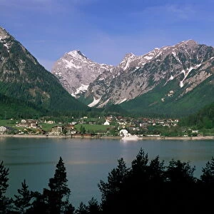
Postcard : Geological map of the European Alps, lithograph, published in 1897


![]()
Cards from Fine Art Storehouse
Geological map of the European Alps, lithograph, published in 1897
Geological map of the European Alps. Lithograph, published in 1897
Unleash your creativity and transform your space into a visual masterpiece!
Media ID 14756398
© This content is subject to copyright
Alps Austria Basalt Carboniferous Croatia Devonian European Alps European Culture Geological Geology Granite Istria Jurassic Lake Constance Lake Garda Lake Geneva Mediterranean Sea Milan Munich Period Serpentine Slate Slovenia Switzerland Triassic Turin Adria Alluvium Cretaceous Period Devonian Period Diluvium Diorite Gabbro Geological Map Gulf Of Genoa Gulf Of Venice Jurassic Period Permian Permian Period Porphyry Shale Silurian Tertiary Triassic Period
Postcards (8 pack of A6)
Set of 8, A6 Postcards, featuring the same image on all cards in a set. Printed on 350gsm premium white satin card, the back of the postcard includes space to write messages and an area for the address and stamp. Size of each postcard is 15cm x 10.6cm.
Photo postcards are a great way to stay in touch with family and friends.
Estimated Product Size is 15cm x 10.6cm (5.9" x 4.2")
These are individually made so all sizes are approximate
Artwork printed orientated as per the preview above, with landscape (horizontal) or portrait (vertical) orientation to match the source image.
FEATURES IN THESE COLLECTIONS
> Fine Art Storehouse
> Map
> Historical Maps
> Fine Art Storehouse
> Map
> Italian Maps
> Fine Art Storehouse
> Travel Imagery
> Travel Destinations
> Venice, Italy
> Arts
> Contemporary art
> Landscapes
> Mountain landscapes
> Arts
> Landscape paintings
> Landscape art
> Landscape paintings
> Arts
> Landscape paintings
> Landscape art
> Mountain landscapes
> Europe
> Austria
> Lakes
> Lake Constance
> Europe
> Austria
> Lakes
> Related Images
> Europe
> Austria
> Related Images
EDITORS COMMENTS
This lithograph from 1897 showcases a detailed geological map of the majestic European Alps. The intricate print encompasses the vast mountain range, stretching across several countries including Switzerland, Italy, France, Germany, Austria, and Slovenia. The map also highlights significant landmarks such as the Mediterranean Sea, Adria, Istria, Turin, Munich, Milan, Croatia and breathtaking lakes like Geneva Constance and Garda. The engraving beautifully illustrates various geological periods that have shaped this awe-inspiring landscape over millions of years. From the Tertiary to Alluvium and Diluvium deposits to Cretaceous and Jurassic periods leading back to Triassic times; each era is meticulously depicted on this historic artwork. The diverse rock formations are showcased with precision - slate and shale alongside granite and basalt; trachyte contrasting with porphyry; melaphyre harmonizing with diabase; diorite blending into gabbro while amphibolite gracefully meets serpentine. This lithograph not only serves as a visual masterpiece but also offers an intriguing glimpse into Earth's ancient history. It allows us to appreciate the rich tapestry of geological wonders that have shaped both the physical landscape of Europe's most iconic mountain range as well as its cultural heritage.
MADE IN THE UK
Safe Shipping with 30 Day Money Back Guarantee
FREE PERSONALISATION*
We are proud to offer a range of customisation features including Personalised Captions, Color Filters and Picture Zoom Tools
SECURE PAYMENTS
We happily accept a wide range of payment options so you can pay for the things you need in the way that is most convenient for you
* Options may vary by product and licensing agreement. Zoomed Pictures can be adjusted in the Basket.