Postcard > Europe > Hungary > Maps
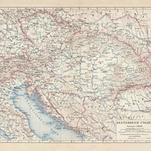
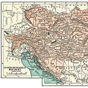
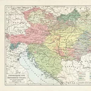
Postcard : Ethnological map of the Austro-Hungarian Empire, lithograph, published in 1897


![]()
Cards from Fine Art Storehouse
Ethnological map of the Austro-Hungarian Empire, lithograph, published in 1897
Ethnological map of the Austro-Hungarian Empire. Lithograph, published in 1897
Unleash your creativity and transform your space into a visual masterpiece!
ZU_09
Media ID 18292213
Postcards (8 pack of A6)
Set of 8, A6 Postcards, featuring the same image on all cards in a set. Printed on 350gsm premium white satin card, the back of the postcard includes space to write messages and an area for the address and stamp. Size of each postcard is 15cm x 10.6cm.
Photo postcards are a great way to stay in touch with family and friends.
Estimated Product Size is 15cm x 10.6cm (5.9" x 4.2")
These are individually made so all sizes are approximate
Artwork printed orientated as per the preview above, with landscape (horizontal) or portrait (vertical) orientation to match the source image.
FEATURES IN THESE COLLECTIONS
> Fine Art Storehouse
> Map
> Historical Maps
> Europe
> Hungary
> Related Images
> Maps and Charts
> Related Images
EDITORS COMMENTS
This lithograph, titled "Ethnological map of the Austro-Hungarian Empire" takes us on a journey back in time to the year 1897. Created by the talented artist ZU_09, this print offers a fascinating glimpse into the diverse ethnic makeup of one of Europe's most powerful empires during that era. The intricate details and vibrant colors bring this historical map to life, showcasing the vast territories encompassed within the Austro-Hungarian Empire. From Bohemia to Transylvania and from Galicia to Dalmatia, each region is meticulously depicted with its distinct cultural identity. As we study this ethereal artwork, our eyes are drawn to an array of symbols representing different ethnic groups inhabiting these lands. Each symbol tells a story - a tale of centuries-old traditions, languages spoken, and customs followed by these communities. Beyond its aesthetic appeal, this lithograph serves as an invaluable historical document. It provides valuable insights into how various cultures coexisted within this multi-ethnic empire at a time when nationalism was gaining momentum across Europe. Whether you are an art enthusiast or history buff, "Ethnological map of the Austro-Hungarian Empire" will undoubtedly captivate your imagination and transport you back in time. Let it serve as a reminder that diversity has always been at the heart of human civilization – uniting us through our differences while celebrating our shared heritage.
MADE IN THE UK
Safe Shipping with 30 Day Money Back Guarantee
FREE PERSONALISATION*
We are proud to offer a range of customisation features including Personalised Captions, Color Filters and Picture Zoom Tools
SECURE PAYMENTS
We happily accept a wide range of payment options so you can pay for the things you need in the way that is most convenient for you
* Options may vary by product and licensing agreement. Zoomed Pictures can be adjusted in the Basket.